
A road matching method and device based on vehicle satellite positioning data

A technology of satellite positioning and data, which is applied to road network navigators and other directions, can solve the problems of affecting the upper limit of the number, the error of matching results, and reducing the accuracy of road matching results, so as to achieve the effect of improving the accuracy

Active Publication Date: 2020-09-08
BEIJING TRANWISEWAY INFORMATION TECH
View PDF8 Cites 0 Cited by
  • Summary
  • Abstract
  • Description
  • Claims
  • Application Information

AI Technical Summary

Problems solved by technology

The road matching of the existing vehicle satellite positioning data is usually based on the road connectivity detection of adjacent satellite positioning points based on the breadth-first search algorithm (also known as BFS); among them, the breadth-first search algorithm does not have a priority strategy in the search, resulting in many Useless calculations affect the response speed of the bottom layer, and further affect the upper limit of the number of connectable paths between two adjacent location points (satellite positioning points), which leads to errors in the final road matching results and reduces the accuracy of road matching results. Rate

Method used


Image

  • A road matching method and device based on vehicle satellite positioning data
  • A road matching method and device based on vehicle satellite positioning data
  • A road matching method and device based on vehicle satellite positioning data

Examples


Embodiment 1

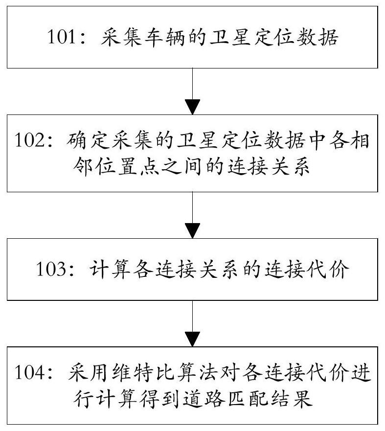
[0065] According to an embodiment of the present invention, a road matching method based on vehicle satellite positioning data is provided, such as figure 1 shown, including:

[0066] Step 101: collecting satellite positioning data of the vehicle;

[0067] Specifically, collect the satellite positioning data reported by the on-board equipment of the vehicle;

[0068] Wherein, the satellite positioning data includes: a series of position points in the time dimension (ie, a series of position points generated in chronological order) and the driving direction at each position point.

[0069] Step 102: Determine the connection relationship between adjacent position points in the collected satellite positioning data;

[0070] In this embodiment, step 102 specifically includes:

[0071] Step 102-1: According to the time dimension, successively use all other position points in a series of position points except the last position point as the current position point;

[0072] Step ...

Embodiment 2

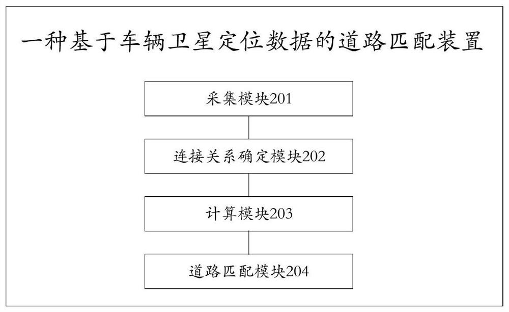
[0106] According to an embodiment of the present invention, a road matching device based on vehicle satellite positioning data is provided, such as image 3 shown, including:

[0107] The collection module 201 is used to collect the satellite positioning data of the vehicle;

[0108] A connection relationship determining module 202, configured to determine the connection relationship between each adjacent position point in the satellite positioning data collected by the acquisition module 201;

[0109] A calculation module 203, configured to calculate the connection cost of each connection relationship determined by the connection relationship determination module 202;

[0110] The road matching module 204 is configured to use the Viterbi algorithm to calculate each connection cost calculated by the calculation module 203 to obtain a road matching result.

[0111] According to the embodiment of the present invention, the collection module 201 is specifically used to: collect t...


PUM


Abstract

The invention discloses a road matching method and device based on vehicle satellite positioning data, and belongs to the field of intelligent traffic big data. The method comprises the steps that satellite positioning data of a vehicle is collected; connection relations between every two adjacent position points in the acquired satellite positioning data are determined; the connection price of each connection relation is calculated; each connection price is calculated through a Viterbi algorithm to obtain a road matching result. According to the method, a candidate path set of all the position points is determined, the most likely matched candidate path is preferentially processed by adopting a priority strategy, all the connection relations of all adjacent position points are found in sequence, and then calculation of the connection price of each connection relation and road matching are carried out; in the process, useless calculation does not exist, the response speed of a bottom layer cannot be influenced, and the upper limit of the number of the communication paths between every two adjacent position points is not affected, so that the road matching accuracy is greatly improved.

Description

technical field [0001] The invention relates to the field of intelligent transportation big data, in particular to a road matching method and device based on vehicle satellite positioning data. Background technique [0002] Vehicle satellite positioning data is satellite positioning data collected in real time by vehicles equipped with satellite positioning vehicle equipment at a certain frequency, and the data is sent to the satellite positioning monitoring center through a wireless network. [0003] The road matching of vehicle satellite positioning data is the calculation and processing process of matching the collected satellite positioning data to known roads. According to the longitude, latitude and other data of the vehicle, the matching degree is calculated with the spatial position data of the known roads, so as to obtain Get the best matching road from the satellite positioning data. The road matching of the existing vehicle satellite positioning data is usually b...

Claims


Application Information

Patent Timeline
Patent Type & Authority Patents(China)
IPC IPC(8): G01C21/30
CPCG01C21/30
Inventor 于博文孙智彬杨晓明张缙张鹤高
Owner BEIJING TRANWISEWAY INFORMATION TECH
Learn More