
Area-array gazed infrared remote-sensing-image space-time three-dimensional noise identification and compensation method

A technology of remote sensing image and compensation method, which is applied in the field of remote sensing image processing to reduce the burden of calibration, improve accuracy and convenience, and achieve accurate positioning

Active Publication Date: 2018-08-31
BEIJING INST OF SPACECRAFT SYST ENG
View PDF5 Cites 2 Cited by
  • Summary
  • Abstract
  • Description
  • Claims
  • Application Information

AI Technical Summary

Problems solved by technology

[0005] The technical solution of the present invention is to overcome the deficiencies of the prior art, and provide a method for identifying and compensating spatio-temporal three-dimensional noise in high-orbit surface-array infrared remote-sensing images specifically for detectors of high-orbit staring infrared remote-sensing images, so as to improve high-orbit The data quality of area array infrared remote sensing images and the quality of information products, promote the application level, and improve application efficiency

Method used


Image

  • Area-array gazed infrared remote-sensing-image space-time three-dimensional noise identification and compensation method
  • Area-array gazed infrared remote-sensing-image space-time three-dimensional noise identification and compensation method
  • Area-array gazed infrared remote-sensing-image space-time three-dimensional noise identification and compensation method

Examples


Embodiment Construction

[0034] The present invention will be described in detail below in conjunction with the accompanying drawings and specific embodiments.

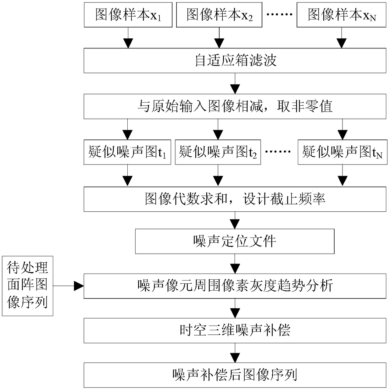
[0035] Such as figure 1 As shown, taking TEL2000 type cooling type area array long-wave infrared camera remote sensing data three-dimensional noise detection and compensation as an example, the specific implementation method of the present invention is as follows:

[0036] (1) Sample selection

[0037] Randomly select different N-format arrays to stare at infrared remote sensing images x i ,(i∈[1,N]), forming a noise analysis image sample set X={x 1 ,x 2 ,...x N};

[0038] In order to ensure the consistency of the sample data, the noise analysis image sample set needs to be the primary high-orbit surface array staring infrared image product that has undergone systematic radiation correction.

[0039] In order to ensure the diversity and universality of the sample data, the noise analysis image sample set needs to select images of differ...


PUM


Abstract

The invention provides an area-array gazed infrared remote-sensing-image space-time three-dimensional noise identification and compensation method. In the method, aiming at an unstable three-dimensional noise generated by row, column and time axes in an area-array gazed infrared image, accurate noise positioning and compensation processing are realized. The method is realized by five processes ofsample selection, spatial filtering, noise primary selection, noise positioning file making and noise compensation. The method has characteristics that the method does not rely on blackbody calibration information, noise positioning is accurate, noise pixels are only processed and image information is not lost. When an existing noise filtering method is applied to an area-array infrared remote-sensing image sequence possessing the space-time three-dimensional unstable noise, a calculated amount is large, the image information is easy to lose and so on. In the invention, the above disadvantagesare overcome; the method can be applied to the on-orbit processing of an infrared image, quality improvement and other fields; and area-array infrared-image geometric matching accuracy can be increased.

Description

technical field [0001] The invention relates to a space-time three-dimensional noise recognition and compensation method for staring infrared remote sensing images of high-orbit area arrays, which is used for improving the quality of staring area array infrared remote sensing images and belongs to the technical field of remote sensing image processing. Background technique [0002] Due to defects in the production process and materials of infrared focal plane array detectors, some array elements may fail, causing the response to infrared radiation to deviate significantly from the normal value. With the upgrading of infrared imaging systems, detectors, signal transmission and processing systems are highly integrated, and the combination of detector noise and signal processing noise becomes more complex, which will change with the environment and time of objects and objects, forming Three-dimensional noise (image row axis, column axis and time axis). For an area array infrar...

Claims


Application Information

Patent Timeline
Patent Type & Authority Applications(China)
IPC IPC(8): G06T5/00G06T7/00
CPCG06T7/0002G06T2207/10048G06T2207/10032G06T2207/30168G06T5/70
Inventor 孔祥皓陈卓一马健刘凤晶李果刘宁朱玛李响王丽俐
Owner BEIJING INST OF SPACECRAFT SYST ENG
Learn More