
Intelligent recognition method for geological radar echo signal physical property deconstruction and detection target digital reconstruction

A geological radar and echo signal technology, applied in the field of engineering geophysical prospecting and geological survey, can solve the problems of echo signal loss, interference signal strength, weakening, etc., so as to reduce uncertainty, solve multiple solutions, and improve accuracy. Effect

Pending Publication Date: 2018-07-10
BEIJING AEROSPACE GEOTECHN ENG INST
View PDF15 Cites 13 Cited by
  • Summary
  • Abstract
  • Description
  • Claims
  • Application Information

AI Technical Summary

Problems solved by technology

The geological radar with the characteristics of fast, non-destructive, and high efficiency has become an effective technical means widely used in the field of engineering geological survey, but the propagation process of electromagnetic waves in the ground is very complicated and the attenuation is serious, and the reflection signals of deep formations or small geological bodies are often very poor However, the interference signals of various noises and clutters are very strong, which leads to further weakening or even burying of the weak and useful reflection information in the deep under the background of strong interference, or excessive processing in the process of data processing to reduce noise and improve signal-to-noise ratio. The echo signal is lost, so it is impossible to extract useful information of small deep underground targets to meet the needs of large-depth exploration and high-resolution interpretation of ground radar

Method used


Image

  • Intelligent recognition method for geological radar echo signal physical property deconstruction and detection target digital reconstruction
  • Intelligent recognition method for geological radar echo signal physical property deconstruction and detection target digital reconstruction
  • Intelligent recognition method for geological radar echo signal physical property deconstruction and detection target digital reconstruction

Examples


Embodiment Construction

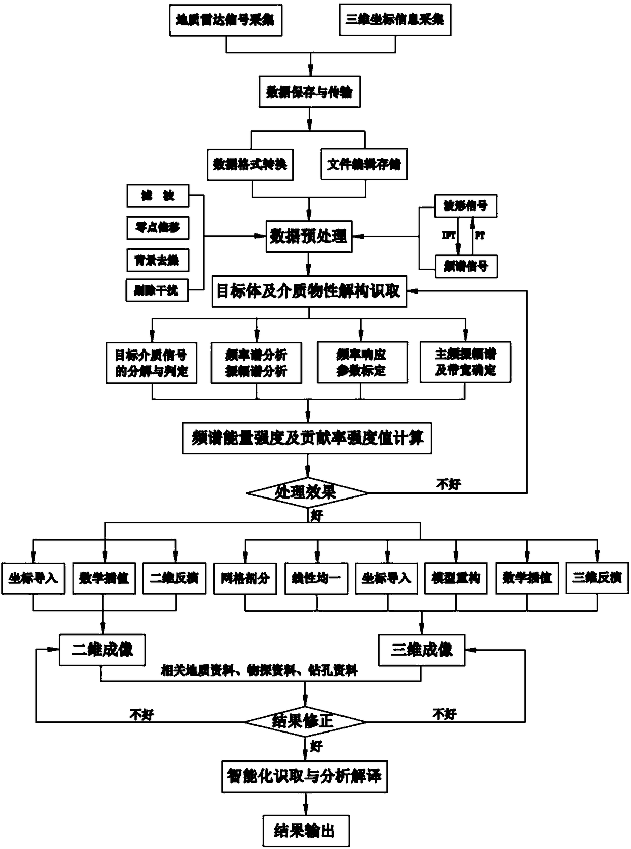
[0042] The method for deconstructing physical properties of geological radar echo signals and intelligently reconstructing detection target digital reconstruction according to the present invention will be further described below in conjunction with the accompanying drawings and specific embodiments:

[0043] Based on the different electromagnetic physical properties of the underground, each of them has its own and unique resonance frequency response in the radar reflection echo signal. Through the analysis of the resonant frequency of the physical properties of different target media in the ground radar reflection echo signal, the frequency response characteristics of the detected target are deconstructed, and the contribution rate of the detected target medium in the echo signal spectrum is used to quantify its presence in the medium. The spectral energy intensity in the space particle reconstructs the spatial geometry of the measured target and the spatial distribution of th...


PUM


Abstract

An intelligent recognition method for geological radar echo signal physical property deconstruction and detection target digital reconstruction is disclosed. In the method, the characteristic that a geological radar reflected wave signal has the unique resonance of the frequency response and detection target body frequency response features during the propagation of an underground medium are utilized, an intensity value of the spectral energy contribution rate of the measured target medium response frequency is calculated, inversion and analysis are performed, deep, weak or tiny reflected signals are effectively extracted and identified, interference of clutter signals are removed, and the spatial distribution of the intensity of the spectral energy contribution rate of underground targetbodies or anomaly bodies is interpreted. According to the invention, the detection depth of a geological radar and the accuracy of the interpretation are substantially improved, the uncertainty of theinterpretation of the geological radar results due to the constraints of the differences of data interpreters or the lack of experience and the like is reduced, the problem of the multi-solution of underground anomaly interpretation of the geological radar exploration to some extent is solved, the intelligent recognition of target body reconstruction and anomaly body features can be realized, andthus a new method for digital signal processing and analysis interpretation is provided for the geological radar detection technology.

Description

Technical field: [0001] The invention relates to the fields of engineering geophysical prospecting and geological survey, in particular to an intelligent recognition method for physical property deconstruction of geological radar echo signals and digital reconstruction of detection targets. Background technique: [0002] With the rapid development of urban modernization, large-scale high-rise buildings, ultra-deep underground foundations, and intricate rail transit and other infrastructure constructions are increasing. Geological exploration tasks and geological problems are also increasing and prominent. The original traditional geological Reconnaissance techniques and methods are in many cases a little "helpless". The geological radar with the characteristics of fast, non-destructive, and high efficiency has become an effective technical means widely used in the field of engineering geological survey, but the propagation process of electromagnetic waves in the ground is ve...

Claims


Application Information

Patent Timeline
IPC IPC(8): G01S7/295
CPCG01S7/295
Inventor 李耀华张维平
Owner BEIJING AEROSPACE GEOTECHN ENG INST
Learn More