Underwater river landform measurement device and measurement method for large rivers

A technology for topographic surveying and surveying methods, which is applied in surveying devices, open-air water source surveys, radio wave surveying systems, etc., can solve the problems of complex surveying operation process, single means of river water depth surveying, low operation efficiency, etc., so as to improve operation efficiency. , reduce labor intensity and realize the effect of automation

Pending Publication Date: 2018-06-05
YUNNAN UNIV +1
View PDF14 Cites 16 Cited by
  • Summary
  • Abstract
  • Description
  • Claims
  • Application Information

AI Technical Summary

Problems solved by technology

[0007] Compared with ocean bathymetry, the channel survey of inland rivers and rivers is relatively simple. However, the water depth of the river channel is s...

Method used


Image

  • Underwater river landform measurement device and measurement method for large rivers
  • Underwater river landform measurement device and measurement method for large rivers
  • Underwater river landform measurement device and measurement method for large rivers

Examples


Embodiment Construction

[0035] In order to better understand the technical solutions of the present invention, the present invention will be further described below in conjunction with the accompanying drawings and specific embodiments.

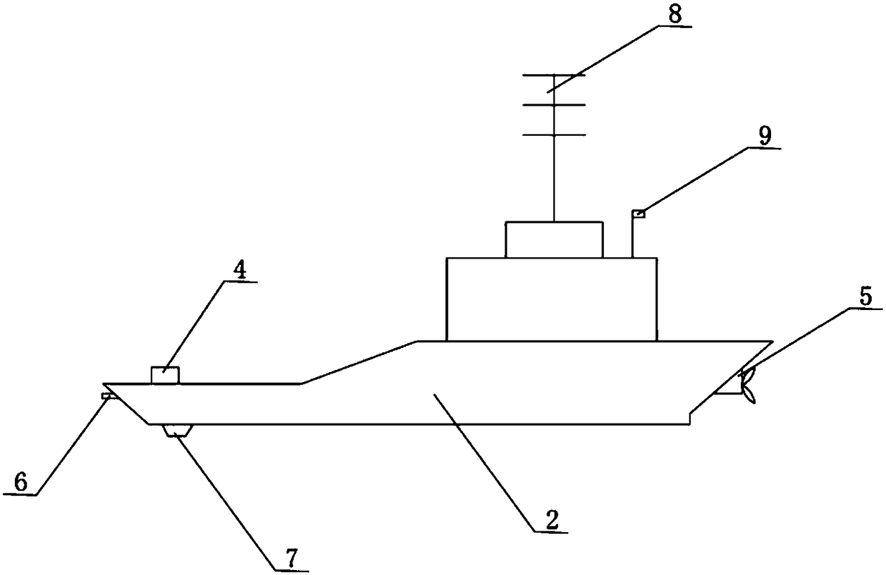
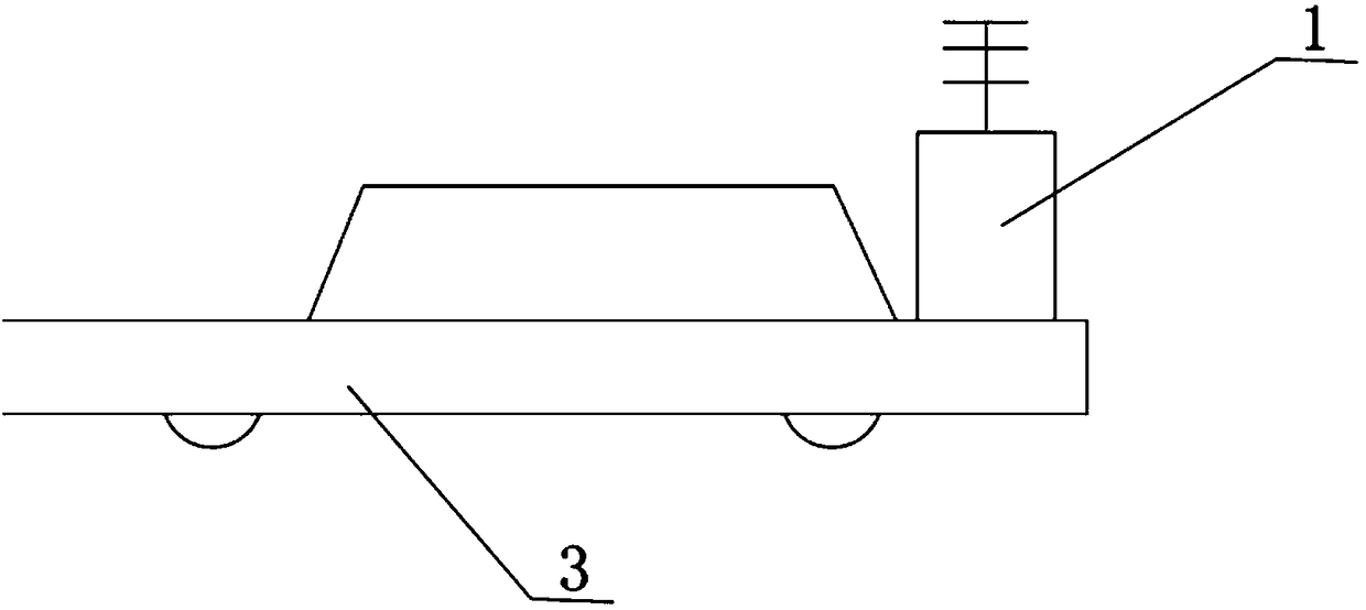
[0036] Such as figure 1 , figure 2 and image 3 As shown, an underwater topography measuring device for a large river includes a control base station 1 and a detection ship 2. The control base station 1 is set on a transfer vehicle 3, and the transfer vehicle 3 is loaded to control the base station 1 to move on the river bank.

[0037] Two floating bodies 5 are installed symmetrically at the rear of the exploration ship 2, and propellers are installed at the tail of the floating bodies 5, and the exploration ship 2 is propelled by means of propellers.

[0038] The forward looking collision avoidance sonar 6 is installed in front of the exploration ship 2, and the integrated sonar 7, communication antenna 8, GPS antenna 9 and navigation system 10 are installed on ...


PUM


Abstract

The invention discloses an underwater river landform measurement device and a measurement method for large rivers. The device comprises a control base station and an exploitation ship, wherein a radarcollision-avoiding sonar is arranged in the front of the exploitation ship; a combined sonar, a communication antenna, a GPS (Global Positioning System) antenna and a sailing system are arranged on the exploitation ship; the combined sonar comprises a lateral scanning sonar and a multi-beam echo sounder; by using the combined sonar on the exploitation ship, landform information of the bottom of ariver is measured, obstacle information on a sailing line is acquired by using the radar collision-avoiding sonar, communication with the control bases station is realized through the communication antenna, real-time position signals are acquired through the GPS antenna, and the sailing speed and the sailing direction of the exploitation ship are controlled by the control station through the sailing system. The device is based on a multi-beam echo sounding technique, is applicable to river bottom landforms, is capable of exploring obstacles in a forwarding direction of the exploitation ship through the foresight collision-avoiding sonar in the front of the exploitation ship, ensuring the sailing security of the exploitation ship and greatly alleviating working intensity, and is high in measurement efficiency.

Description

technical field [0001] The invention relates to the technical field of channel surveying, in particular to an underwater channel topography measuring device and a measuring method for large rivers. Background technique [0002] my country's inland includes a large number of large rivers and rivers. In the process of inland river management, it is often necessary to draw topographic maps of the bottom of the river. In the past, the measurement method used manual measurement to measure the depth of the river. This method cannot be drawn well. Topography and landforms at the bottom of the channel. [0003] With the advancement of science and technology, various advanced equipment emerge in an endless stream, and equipment that can be used to measure water depth continues to be used. [0004] There are already many instruments and equipment to measure underwater topography. There are two main types: ocean bottom topography measurement, and underwater sonar detection based on the...

Claims


Application Information

Patent Timeline
IPC IPC(8): G01S15/87G01S15/89G01S15/93G01C13/00
CPCG01C13/00G01S15/87G01S15/89G01S15/8902G01S15/93Y02A90/30
Inventor 季漩李运刚罗贤何大明樊辉陈云芳
Owner YUNNAN UNIV
Why Eureka
Try Eureka