Navigation and location system and method

A technology of navigation positioning and navigation information, applied in the field of navigation, can solve the problems of weak received signal strength, easy to be interfered, difficult to locate, etc., and achieve the effect of long signal transmission distance, high signal strength and strong anti-interference ability

Active Publication Date: 2017-12-22
GUILIN UNIV OF ELECTRONIC TECH
View PDF3 Cites 3 Cited by
  • Summary
  • Abstract
  • Description
  • Claims
  • Application Information

AI Technical Summary

Problems solved by technology

[0005] The purpose of the present invention is to provide a navigation and positioning system and method. The technical problem to be solved is: the satellite signal is transmitted over a long distance with a relatively low transmission power, and the strength of the received signal is weak and is easily interfered. It is difficult or impossible to locate indoors or under occlusion

Method used


Image

  • Navigation and location system and method
  • Navigation and location system and method
  • Navigation and location system and method

Examples


Embodiment 2

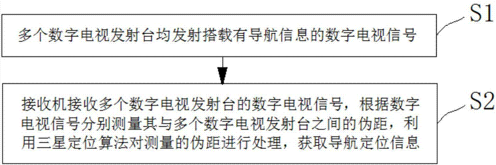
[0071] like figure 2 As shown, a navigation positioning method includes the following steps:

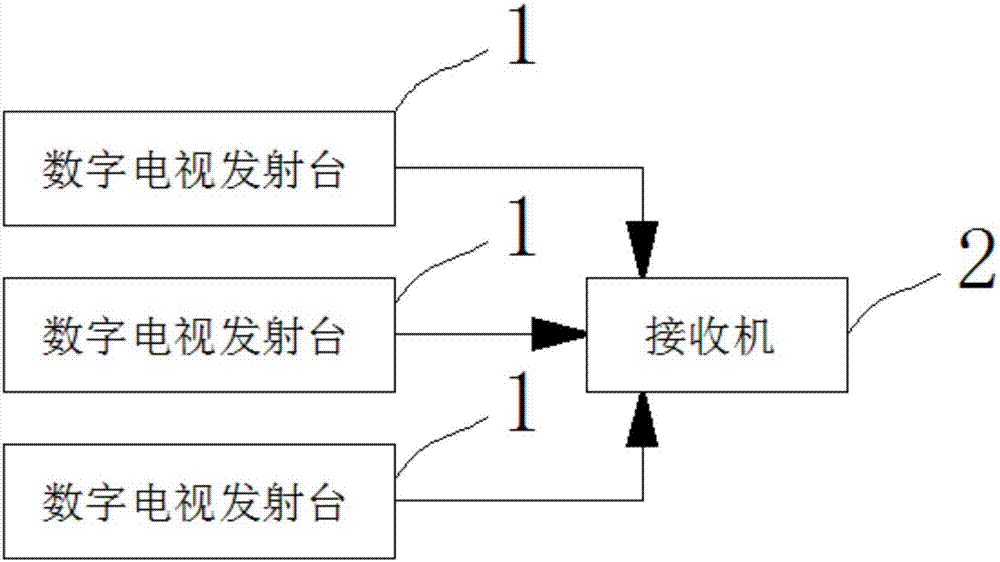
[0072] Step 1: Multiple digital TV transmitting stations 1 all transmit digital TV signals carrying navigation information;

[0073] Step 2: Receiver 2 receives the digital TV signals of multiple digital TV transmitting stations 1, measures the pseudo-ranges between it and multiple digital TV transmitting stations 1 respectively according to the digital TV signals, and uses the Samsung positioning algorithm to perform the pseudo-range measurement on the measured pseudo-ranges Processing, to obtain navigation and positioning information.

[0074] In the above-mentioned embodiment, a plurality of digital TV transmitting stations 1 transmit digital TV signals carrying navigation information. The signal transmission distance of the digital TV signals is long, the signal strength is high, and the anti-interference ability is strong. In indoor environments or where satellite signals are ...


PUM


Abstract

The invention relates to a navigation and location system and method. The navigation and location system includes multiple digital television transmitting stations which all transmit digital television signals carrying navigation information, and a receiver which receives the digital television signals of the digital television transmitting stations, measures the pseudo distance from each digital television transmitting station according to the corresponding digital television signal, and processes the measured pseudo distances through a three-satellite location algorithm to get navigation and location information. Compared with the prior art, the system has high signal intensity and strong anti-interference ability; and when the indoor environment or the satellite signal is blocked, the receiver can continuously receive digital television signals carrying navigation information and carry out navigation and location through the digital television signals carrying navigation information, and thus, the precision of navigation and location is enhanced.

Description

technical field [0001] The invention relates to the technical field of navigation, in particular to a navigation positioning system and method. Background technique [0002] China's BeiDou Navigation Satellite System (BDS) is a global satellite navigation system developed by China itself. It is the third mature satellite navigation system after the US Global Positioning System (GPS) and the Russian GLONASS Satellite Navigation System (GLONASS). Beidou Satellite Navigation System (BDS), GPS of the United States, GLONASS of Russia, and GALILEO of the European Union are certified suppliers by the United Nations Satellite Navigation Commission. [0003] The Beidou satellite navigation system consists of three parts: the space segment, the ground segment and the user segment. It can provide all kinds of users with high-precision, high-reliability positioning, navigation, and timing services all-weather and all-weather throughout the country, and has short-message communication. ...

Claims


Application Information

Patent Timeline
IPC IPC(8): G01S19/48G01C21/20
CPCG01C21/206G01S19/48
Inventor 蔡成林王向阳吴金凯邱云翔谷洪浩蔡劲马力于鹏
Owner GUILIN UNIV OF ELECTRONIC TECH
Why Eureka
Try Eureka