
Compressed Storage and Publishing Method for Tiled Raster Maps

A raster map and compressed storage technology, which is applied in image coding, image data processing, geographic information database, etc., can solve the problem of poor tile data storage space and achieve the effect of reducing the number of tiles and storage space

Active Publication Date: 2021-01-01
CENNAVI TECH
View PDF9 Cites 0 Cited by
  • Summary
  • Abstract
  • Description
  • Claims
  • Application Information

AI Technical Summary

Problems solved by technology

[0019] However, no matter the image compression method or the image color reduction method is for the processing of the tile image data itself, the number of tiles will not change before and after processing, so the existing technology partially solves the problem of the size of the tile data transmission, but for Solving the storage space problem of tile data on the server side is not effective

Method used


Image

  • Compressed Storage and Publishing Method for Tiled Raster Maps
  • Compressed Storage and Publishing Method for Tiled Raster Maps
  • Compressed Storage and Publishing Method for Tiled Raster Maps

Examples


Embodiment Construction

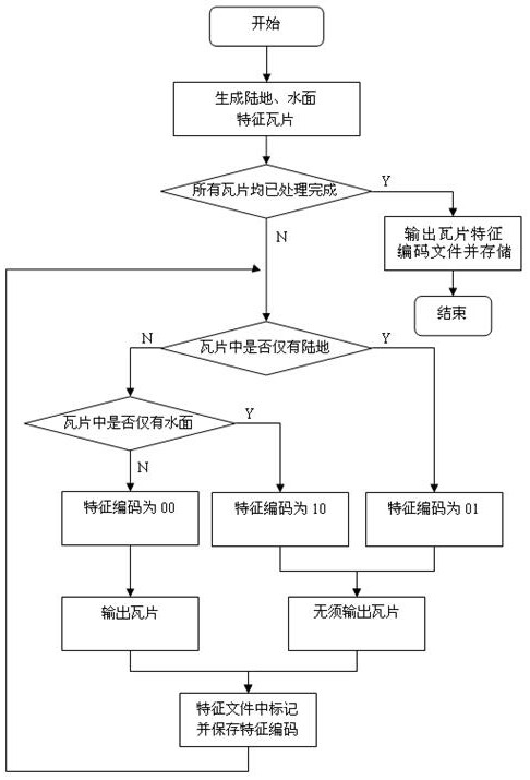
[0033] Such as figure 1 As shown, the compression storage method of the tiled grid map of the present invention comprises the following steps:

[0034] Step 1. Classify according to the tile image display features of the tiled raster map, and use binary codes to express the categories of different tile images. 00 means incompressible tiles containing ground objects, and 01 means compressible tiles with only land , 10 represents a compressible tile with only water surface;

[0035] Step 2. Generate feature tiles according to the category of the tile image. The feature tiles include land feature tiles with a binary code of 01 and water surface feature tiles with a binary code of 10. The color matching of the land feature tiles and water surface feature tiles is rendered as 256x256 solid color tiles;

[0036] Step 3. When the map rendering tool cuts the image to produce raster map tiles, it performs image detection, feature classification and marking on each tile. When cutting...


PUM


Abstract

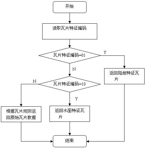
The invention discloses tile type grid raster map compression storage and release methods. The compression storage method comprises the steps of displaying a feature type for a tile image, and dividing the tile image into an incompressible tile containing a ground object and a feature tile only with land or water surface; when a map rendering tool cuts the image to generate the tiles, performing image detection, feature classification and marking on each tile, and storing the tiles as index files; and storing the map tiles, directly outputting and storing the incompressible tile, and not outputting and storing the feature tile. The release method comprises the steps of quickly retrieving and reading out feature codes corresponding to the tiles from the index files; and releasing the feature tile by directly adopting the land feature tile or the water surface feature tile, and releasing the incompressible tile by using corresponding original tile image data. According to the methods, a feature index table is established; a large amount of repeated redundant tile data is deleted; the tile quantity and the storage space required for map display are greatly reduced; the release efficiency is effectively improved; and the display performance is almost not influenced.

Description

technical field [0001] The invention relates to a method for compressing, storing and publishing tiled grid maps. Background technique [0002] WebGIS (Web Geographic Information System) is the combination of the Internet and GIS technology. WebGIS technology enables users to obtain a large number of practical personal location services through web browsers, and can transmit spatial information to thousands of households through the network. The basic core function of WebGIS technology is fast and exquisite map browsing and display. [0003] Online map services usually use tiled raster images of 256x256 or 300x300 pixels, and commonly published raster images are in PNG, JPG, or GIF format. Tiles and tile images are small images of uniform size and format cut by a special agreed method, and the width and height of tile images are generally 256 pixels. The tile data of the grid map ranges from 0 to n levels (n is usually 17 to 23, that is, the grid map has 18 to 24 scale lev...

Claims


Application Information

Patent Timeline
Patent Type & Authority Patents(China)
IPC IPC(8): G06F16/29G06T9/00
CPCG06T9/00G06F16/29
Inventor 温宇浩吴红缨蒋晟魏波万栋新杜参军
Owner CENNAVI TECH
Learn More