Remote-sensing-based soil moisture status monitoring method

A soil moisture and remote sensing technology, applied in soil material testing, measuring devices, instruments, etc., can solve the problems of sparse measurement points, poor representativeness, difficult to meet real-time, rapid and large-scale soil moisture monitoring, etc., and meet the requirements of reducing restrictions. Effect

Inactive Publication Date: 2017-06-20
张成才
View PDF1 Cites 7 Cited by
  • Summary
  • Abstract
  • Description
  • Claims
  • Application Information

AI Technical Summary

Problems solved by technology

The traditional soil moisture monitoring method is to monitor by setting up measuring stations, which consumes a lot of manpower, material resources, and financial resources, and the measuring points are sparse, and the regional moisture is replaced by point moisture, which is poor in representation and difficult to meet real-time, rapid and large-scale soil moisture monitoring. needs

Method used


Image

  • Remote-sensing-based soil moisture status monitoring method
  • Remote-sensing-based soil moisture status monitoring method
  • Remote-sensing-based soil moisture status monitoring method

Examples


Embodiment Construction

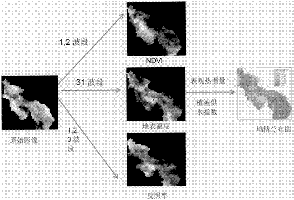
[0016] Surface temperature and vegetation index are two important indicators for remote sensing monitoring of soil moisture. For the bare surface, when other conditions are the same, the surface temperature is also different with different soil moisture content, and the surface temperature can better reflect the soil moisture status. When the remote sensing technology obtains the surface temperature, the soil surface temperature is monitored in areas without vegetation, and the surface temperature of the vegetation canopy is monitored in areas with better vegetation; in general, the surface temperature is determined by soil, vegetation and buildings, etc. The temperature of mixed pixels composed of different types of ground objects, so when the factor of surface temperature is used alone to invert soil moisture, it has a certain accuracy in areas with bare soil and low vegetation coverage, but the accuracy is lower in areas with better vegetation . The amount of soil moisture...


PUM


Abstract

The invention relates to research of a soil moisture status monitoring method through MODIS, Landsat and TM remote sensing data, particularly to research and application of soil moisture status monitoring technology based on MODIS, a TM image integrated application apparent thermal inertia method and a vegetation water supply index method. Based on advantages complementary to each other of multiple-source remote-sensing data, the soil moisture status monitoring method adopting MODIS, Landsat, and TM data is researched, and the soil moisture status monitoring technology based on MODIS, a TM image integrated application apparent thermal inertia method and a vegetation water supply index method is provided. Dependence on ground actually-measured data is reduced, the spatial scale of a soil moisture status monitoring result is increased, and the monitoring accuracy of soil moisture status of the ground with different vegetation covered is improved. The method can fully reflect the time and space changing situation of soil moisture.

Description

[0001] Technical field: [0002] The invention relates to a method for monitoring soil moisture with MODIS and Landsat TM remote sensing data, in particular to the research and application of monitoring soil moisture using the apparent thermal inertia method and vegetation water supply index method based on the integration of MODIS and TM images. [0003] Background technique: [0004] Soil moisture is an important indicator in the fields of hydrology, meteorology, and agricultural science, and an important factor in the soil-plant-atmosphere continuum, which is of great significance to hydrology, agriculture, and drought monitoring. Real-time and accurate monitoring of soil moisture is the basis of modern management in irrigation areas, and it is also a key factor for timely and appropriate irrigation in irrigation areas, saving water resources, and improving agricultural water use efficiency. The traditional soil moisture monitoring method is to monitor by setting up measurin...

Claims


Application Information

Patent Timeline
Patent Type & Authority Applications(China)
IPC IPC(8): G01N33/24
CPCG01N33/246
Inventor 张成才王金鑫孙喜梅朱培乐罗蔚然王普
Owner 张成才
Why Eureka
Try Eureka