Destruction-resistant routing method oriented on GEO/LEO double-layer satellite network
A double-layer satellite network and satellite technology, applied in the field of satellite communication, can solve the problems of high failure rate and severe failure, achieve the effect of accurate evaluation and reduce the number of excitations
- Summary
- Abstract
- Description
- Claims
- Application Information
AI Technical Summary
Problems solved by technology
Method used
Image
Examples
Embodiment Construction
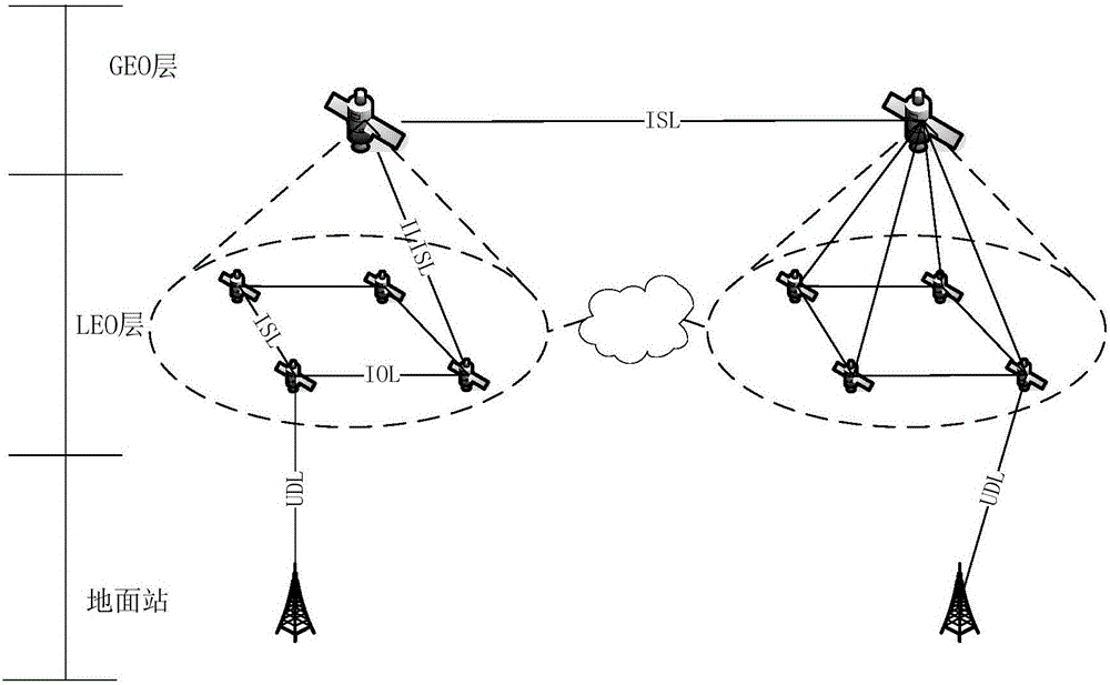
[0027] The present invention is described in further detail now in conjunction with accompanying drawing. First of all, the GEO / LEO double-layer satellite network architecture takes advantage of the large coverage area of GEO satellites and adopts an architecture with redundant GEO layers covering all LEOs to provide unified routing calculations for the entire LEO. Such as figure 1 As shown, the specific two-tier satellite network architecture is:
[0028] The LEO layer refers to the Iridium system, with a total of 66 LEO satellites, divided into 6 orbits, and each orbit has 11 LEO satellites;
[0029] In the GEO layer, 4 GEO satellites are evenly distributed over the equator. The specific coordinates are: the latitude is 0°, the longitude is 30°, 120°, 210°, and 300°, and the altitude is 35786km. Since 3 GEOs can cover the whole world, 4 GEOs can be set to have the redundancy of one GEO. Even if one GEO fails, the entire GEO layer can continue to complete the task.
[0030...
PUM
 Abstract
Description
Claims
Application Information
 - R&D
- Intellectual Property
- Life Sciences
- Materials
- Tech Scout
- Unparalleled Data Quality
- Higher Quality Content
- 60% Fewer Hallucinations
Browse by: Latest US Patents, China's latest patents, Technical Efficacy Thesaurus, Application Domain, Technology Topic, Popular Technical Reports.
© 2025 PatSnap. All rights reserved.Legal|Privacy policy|Modern Slavery Act Transparency Statement|Sitemap|About US| Contact US: help@patsnap.com


