A method for extracting building changes in road domain based on high-resolution images

A technology of high-resolution images and extraction methods, applied in the field of automatic/semi-automatic extraction of newly added buildings on both sides of roads, can solve the problem of road change detection without applying high-spatial-resolution images and without adequate consideration of high-spatial-resolution image roads. Problems such as the complexity of spectral features of road objects

Active Publication Date: 2019-09-27
国交空间信息技术(北京)有限公司 +1
View PDF4 Cites 1 Cited by
  • Summary
  • Abstract
  • Description
  • Claims
  • Application Information

AI Technical Summary

Problems solved by technology

Most of the existing related research focuses on the use of high-resolution images to detect various disasters (such as geological disasters, floods), information extraction of road damage, road area ecological environment evaluation, road information update, etc. (Chen Shirong et al., 2008; Wu Xuesen et al., 2011), and traditional change detection methods are mostly used, mainly relying on the spectral characteristics of images and related models (Xu Yang et al., 2011; Chen Shirong et al., 2008; Ren Yuhuan et al., 2013), but did not fully consider the high The complexity of spatial resolution images and spectral features of road objects
Some foreign scholars have carried out in-depth research on the spectral characteristics of road materials, and used them in the road extraction experiment of aerial hyperspectral images (Herold et al., 2003), but they have not been applied to actual high spatial resolution images and road change detection

Method used


Image

  • A method for extracting building changes in road domain based on high-resolution images
  • A method for extracting building changes in road domain based on high-resolution images
  • A method for extracting building changes in road domain based on high-resolution images

Examples


Embodiment Construction

[0043] The present invention will be further described below with reference to the accompanying drawings and embodiments, but the present invention is not limited to the given examples.

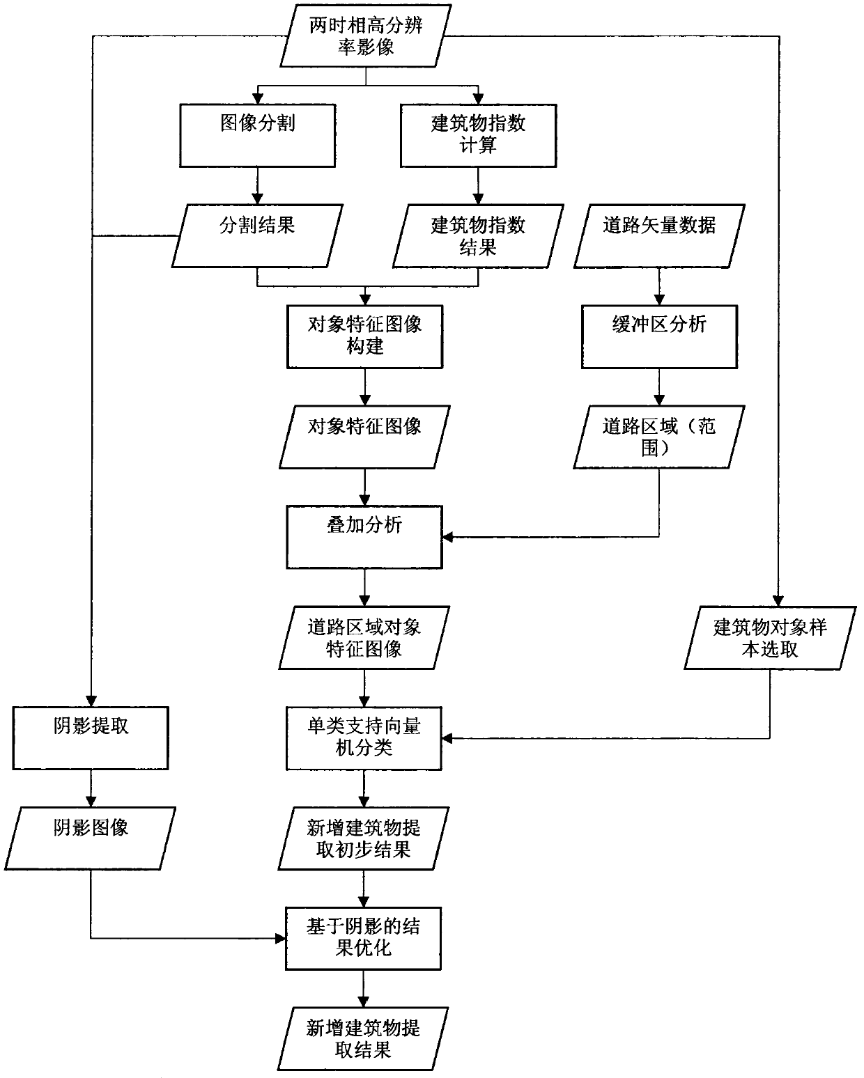
[0044] Technical flow chart of the present invention sees figure 1 . The flow chart ( figure 1 ) are described separately.

[0045] A. Image Segmentation

[0046] Image segmentation is the process of dividing an image into non-overlapping meaningful regions, which are also called image objects. Image segmentation is a prerequisite step in object-oriented methods, and its quality directly affects the performance of subsequent processing analysis. At present, there are many methods of image segmentation, including the segmentation method based on watershed transform and the multi-resolution segmentation method in the commercial software eCognition. This embodiment adopts a multi-level image segmentation method based on a morphological method (Li et al., 2011). This method combines multi-b...


PUM


Abstract

The present invention proposes a method and device for extracting road area building changes based on high spatial resolution remote sensing images. The characteristics or key links of the method and device include: adopting an object-oriented image processing strategy, comprehensively utilizing spectral information of images and Spatial information (including structural index, spatial relationship), using a single-class classification method. In addition, in order to avoid interference (spectral similarity) on the extraction results by feature categories outside the road area, the present invention requires that existing road information be provided in advance, such as the existing road vector diagram. The range of the road domain is extracted by using the existing road vector diagram, and then only new buildings are extracted within the range of the road domain. The method and device for extracting new buildings with high spatial resolution provided by the present invention can greatly reduce the traditional method of using image visual interpretation to obtain new buildings (including illegal buildings) in the road area. Time, improve efficiency, save human resources, and can be used in road maintenance and monitoring business operation systems.

Description

technical field [0001] The invention provides a method and device for extracting road area building changes based on high spatial resolution remote sensing images, in particular to an automatic / semi-automatic extraction of newly added buildings on both sides of a road, belonging to the field of traffic remote sensing. Background technique [0002] Timely and accurate monitoring of the road area of ​​major traffic arterial roads such as national highways and provincial highways is of great significance for maintaining the road environment, road conditions and road traffic safety. According to relevant laws and regulations, construction and development are prohibited in road areas and adjacent areas. Illegal buildings seriously affect the road traffic environment and traffic safety. Some of the illegal constructions discovered so far include constructions that have not obtained construction project planning permits, or constructions that exceed standards; construction materia...

Claims


Application Information

Patent Timeline
Patent Type & Authority Patents(China)
IPC IPC(8): G06T7/246G06T7/155G06T7/11G06K9/62G06K9/46
CPCG06T2207/10032G06T2207/20081G06T2207/20152G06V10/50G06F18/2411G06F18/2433
Inventor 李培军史忠奎罗伦阳柯
Owner 国交空间信息技术(北京)有限公司
Why Eureka
Try Eureka