A Method for Accurately Extracting Ground Vertical Deformation from SAR Datasets of Two Parallel Tracks

A data concentration and precise extraction technology, applied in the direction of instruments, measuring devices, using re-radiation, etc., can solve unrealistic problems

Inactive Publication Date: 2018-11-16
CAPITAL NORMAL UNIVERSITY
View PDF5 Cites 0 Cited by
  • Summary
  • Abstract
  • Description
  • Claims
  • Application Information

AI Technical Summary

Problems solved by technology

Since the ground resolution of SAR images is usually between 1.0 and 30.0 meters, it is unrealistic to arrange such a high density of GPS stations in the entire monitoring range or in the SAR image range

Method used


Image

  • A Method for Accurately Extracting Ground Vertical Deformation from SAR Datasets of Two Parallel Tracks
  • A Method for Accurately Extracting Ground Vertical Deformation from SAR Datasets of Two Parallel Tracks
  • A Method for Accurately Extracting Ground Vertical Deformation from SAR Datasets of Two Parallel Tracks

Examples


Embodiment Construction

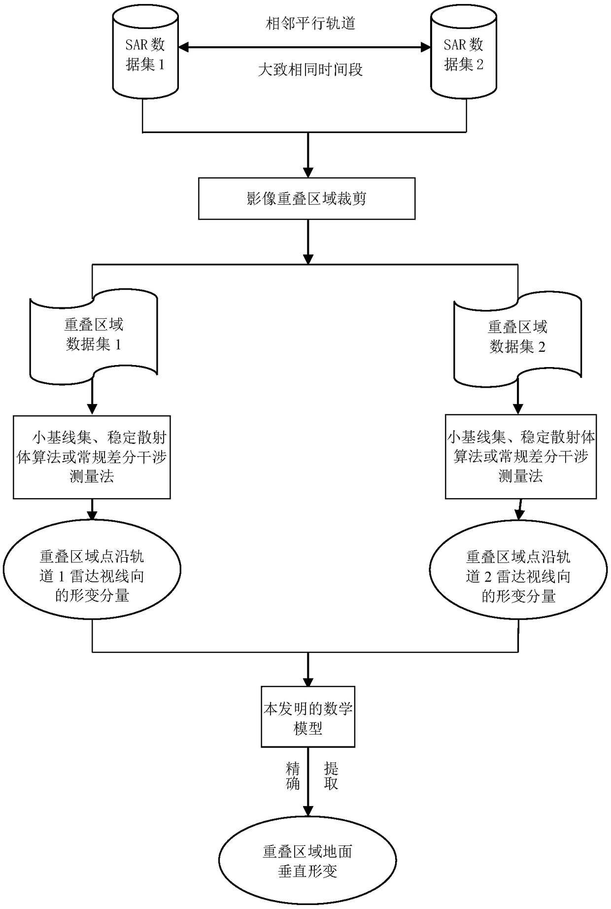
[0041] Such as figure 1 As shown, the flow chart of the method for accurately extracting the ground vertical direction deformation component from two adjacent parallel orbit SAR data sets according to the present invention, the specific implementation steps are as follows:

[0042] Step 1: Selection of SAR data set. Collect SLC SAR image data sets from two adjacent parallel orbits in the same time period as possible;

[0043] Step 2: According to the SAR image overlap area, cut the SAR data set separately to obtain two SAR image data sets covering the overlap area;

[0044] (1) Select the main images of the two data sets separately, and perform multi-view processing in the synthetic aperture radar interferometric processing software (such as: GAMMA, SARscape, SARPROZ, EarthView, Doris, StaMPS, etc.) to generate each of the two data sets Multi-view intensity map of autonomous images;

[0045] (2) Extract the overlapping area of ​​the synthetic aperture radar image data set from the t...


PUM


Abstract

The invention relates to a method of accurately and concentratively extracting ground vertical deformation from two parallel track SAR data. The method comprises steps of (1) a data collection and selection step, in which single look complex SAR data of two adjacent parallel tracks and during an approximate same time period, (2) a two-data set shearing step, in which two SAR data sets covering an overlapped area can be respectively achieved, (3) an interfermetry processing step for the above two SAR data sets in radar interfermetry processing software, in which deformation components of ground points of the two SAR data sets in respective radar gazing directions, and (4) a gaining step of deformation component of the overlapped area ground point in a vertical direction via a provided mathematic model. With only two parallel track SAR data sets, and the provided mathematic model, SAR image overlapped area ground point vertical deformation component can be accurately extracted.

Description

Technical field [0001] The invention relates to the fields of space earth observation, geodetic survey, engineering survey and geological disaster monitoring to obtain ground (the same below the surface) subsidence information, etc., especially the regional ground subsidence monitoring, urban ground subsidence monitoring caused by excessive groundwater mining, mining areas Monitoring of ground subsidence caused by underground mining, monitoring of coseismic deformation of earthquakes, etc. The present invention provides a method for accurately acquiring and extracting the deformation component of the ground point along the vertical direction in the above technical field. Background technique [0002] In the use of synthetic aperture radar SAR (synthetic aperture radar) interferometry to obtain ground (surface) deformation information, whether it is using conventional differential radar interferometry (D-InSAR, Differential synthetic aperture radar interferometry) and multi-tempor...

Claims


Application Information

Patent Timeline
Patent Type & Authority Patents(China)
IPC IPC(8): G01S13/90
CPCG01S13/90G01S13/9023
Inventor 常占强于文祝杰王微
Owner CAPITAL NORMAL UNIVERSITY
Why Eureka
Try Eureka