
Multi-scale Geometric Remote Sensing Image Fusion Method Based on Depth Sparse Autoencoder

A remote sensing image fusion and sparse self-encoding technology, applied in the field of image processing, can solve the problems of insufficient representation of high-resolution multispectral images, spectral distortion of fusion results, and inability to obtain data sets through remote sensing satellites, so as to improve spatial resolution. effects, overcoming color distortion and spectral distortion, reducing the injection of mismatched details

Active Publication Date: 2019-05-03
XIANYANG NORMAL UNIV
View PDF3 Cites 0 Cited by
  • Summary
  • Abstract
  • Description
  • Claims
  • Application Information

AI Technical Summary

Problems solved by technology

The limitation of this method is that the real data set for constructing dictionary atoms cannot be obtained through remote sensing satellites, and the information contained in dictionary atoms cannot fully represent high-resolution multispectral images, resulting in spectral distortion of fusion results.

Method used


Image

  • Multi-scale Geometric Remote Sensing Image Fusion Method Based on Depth Sparse Autoencoder
  • Multi-scale Geometric Remote Sensing Image Fusion Method Based on Depth Sparse Autoencoder
  • Multi-scale Geometric Remote Sensing Image Fusion Method Based on Depth Sparse Autoencoder

Examples


specific Embodiment approach

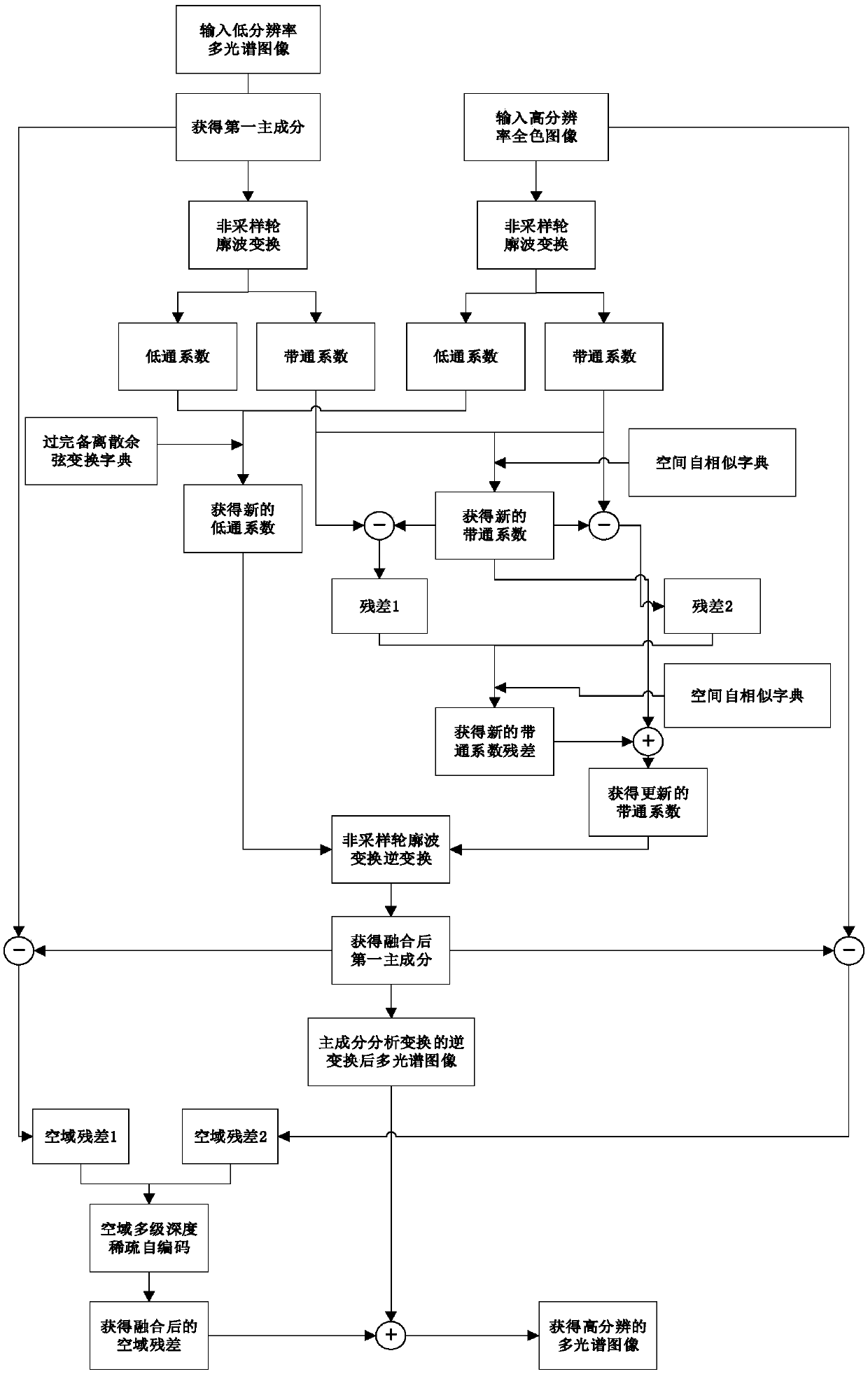
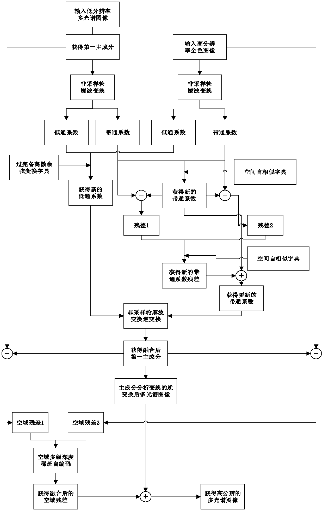
[0035] refer to figure 1 , the specific embodiment of the present invention is as follows:

[0036] Step 1, respectively input the low-resolution multispectral image M and the high-resolution panchromatic image P, and extract the first principal component C1 of the low-resolution multispectral image;

[0037]The size of the low-resolution multispectral image input in the embodiment of the present invention is 64×64×4, and the resolution is 2m; the size of the high-resolution panchromatic image is 256×256, and the resolution is 0.5m;

[0038] The low-resolution multispectral image is transformed by 4 times upsampling, so that its size reaches 256×256×4;

[0039] Perform principal component analysis (PCA) on the multispectral image after upsampling, extract the first principal component after principal component analysis transformation, and define this principal component as the first principal component C1 of the multispectral image, and the size of C1 is 256×256.

[0040] St...


PUM


Abstract

The invention discloses multi-scale geometric remote sensing image fusion based on deep sparse self-coding. The method comprises the following steps of: 1) inputting a low-resolution multispectral image M and high-resolution full-color image P, extracting first principal component C1 of the M; 2) obtaining the low-pass coefficient LM and the band-pass coefficient HM of the C1, and the low-pass coefficient LP and the band-pass coefficient HP of the P; 3) fusing the LM and LP to obtain a low-pass coefficient LN; 4) constructing a space self-similar dictionary DS and fusing the HM and HP to obtain the band-pass coefficient HN under the dictionary DS; 5) updating the HN to obtain the band-pass coefficient HNS; and 6) performing inverse transformation on the LN and the HNS to obtain a fused first principal component C2, updating the C2 to obtain a updated first principal component CS; and 7) performing inverse transformation on the CS to obtain the high-resolution multispectral image. The method reduces the injection of mismatched details, improves the spatial distortions of the fused multispectral images, and can be used for target recognition, terrain classification and remote sensing monitoring.

Description

technical field [0001] The invention belongs to the technical field of image processing, and is a fusion method of multi-scale geometric remote sensing images, which can be used for target identification, ground object classification, remote sensing monitoring and forest resource investigation. Background technique [0002] Remote sensing images, including panchromatic images and multispectral images. Panchromatic images refer to images that include all visible light bands from 0.38-0.76 μm, and panchromatic images acquired by sensors are generally grayscale images. Multispectral image refers to a special image obtained by using two or more sensors to receive different bands of electromagnetic wave information reflected by ground objects. The multispectral image acquired by the sensor generally has four bands. [0003] The fusion of multispectral image and panchromatic image aims to complement the advantages of information to obtain a fused image with both high spatial reso...

Claims


Application Information

Patent Timeline
Patent Type & Authority Patents(China)
IPC IPC(8): G06T3/40G06T5/50
CPCG06T3/4076G06T5/50G06T2207/10032
Inventor 李红苏晓萌雷亮宋笑雪吴粉侠刘小豫段群韩丽娜
Owner XIANYANG NORMAL UNIV
Learn More