Vehicle-mounted inertial navigation system

An inertial navigation system and vehicle technology, applied in navigation, mapping and navigation, road network navigator and other directions, can solve the problems affecting navigation and positioning reliability, angular rate gyro error drift, measurement distance error, etc., to achieve optimal synthesis and the effect of mutual correction

Inactive Publication Date: 2016-09-28
广州飞歌汽车音响有限公司
View PDF9 Cites 17 Cited by
  • Summary
  • Abstract
  • Description
  • Claims
  • Application Information

AI Technical Summary

Problems solved by technology

[0004] However, the above-mentioned inertial navigation system needs to obtain the information of the vehicle body, which inevitably requires the modification of the vehicle, which increases the difficulty of modification and destroys the interface of the original vehicle, resulting in the risk of spontaneous combustion and legal disputes risks of
In addition, due to the use of the speedometer on the vehicle, this will lead to certain errors. At the same time, due to different tire inflation levels and different loads, changes in vehicle speed, tire wear, and road conditions, the vehicle will skid and bounce and the vehicle will turn. The error of measuring the distance, in addition, there is also an error drift in the angular rate gyro, which accumulates over time, which seriously affects the reliability of navigation and positioning

Method used


Image

  • Vehicle-mounted inertial navigation system
  • Vehicle-mounted inertial navigation system
  • Vehicle-mounted inertial navigation system

Examples


Embodiment Construction

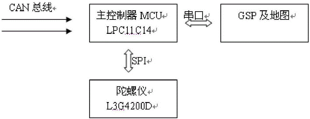
[0049] see figure 1 , the vehicle-mounted inertial navigation system of the present invention comprises: main processor MCU, gyroscope, GPS and map, main processor MCU connects the CAN bus of vehicle audio interface through CAN bus controller to carry out information reading, and main processor connects through SPI interface Gyroscope, connected to GPS and map through serial port.

[0050] The main processor MCU of the present invention selects LPC11C14 of ST Company as the main processor to complete functions such as data processing and external module control. The processor is a microcontroller based on ARM Cotex-M0, which can be used in embedded applications with high integration and low power consumption. ARM Cotex-M0 is the second generation core, which provides a simple instruction set that can achieve deterministic Behavior. Operating frequency up to 50MHZ. Peripherals include up to 32KB of FLASH, 8KB of data memory. The CAN bus controller is connected with the CAN b...


PUM


Abstract

The invention relates to a vehicle-mounted inertial navigation system. According to the system, GPS / DR / MM technologies are combined for vehicle-mounted inertial navigation, vehicle speed pulse signals do not need to be collected, information is directly read through a CAN bus of a vehicle sound port, and vehicle refitting is avoided. The system comprises a main processor MCU, a gyroscope, a GPS and a map, dynamic compensation is adopted for gyroscope zero offset errors, an HDR algorithm is adopted for random drift errors for compensation, the system does not only depend on data basis that inertial navigation is achieved by reading vehicle body information, GPS positioning information and DR system positioning information are further corrected through the map matching technology, and therefore overall vehicle safety and navigation positioning reliability are improved.

Description

technical field [0001] The invention relates to a vehicle navigation and vehicle tracking system, in particular to a vehicle inertial navigation system. Background technique [0002] At present, the global position system (GPS) technology has been applied in car navigation and vehicle tracking systems. However, in some environments such as tunnels, indoors and underground parking lots, the strength of GPS information is so low that GPS receivers basically cannot receive satellite data and thus cannot output position information. An existing solution is to use an on-board navigation system with inertial navigation. [0003] The utility model patent with the authorized announcement number CN202229766U discloses a sensor-based inertial navigation system, which combines inertial navigation technology with GPS technology, including a main control module, a GPS receiving module, a CAN bus control module, a gyroscope sensor, and a speed pulse sensor , tire speed difference sensor...

Claims


Application Information

Patent Timeline
IPC IPC(8): G01C21/28G01C21/16G01S19/47
CPCG01C21/28G01C21/165G01S19/47
Inventor 黄焕立
Owner 广州飞歌汽车音响有限公司
Why Eureka
Try Eureka