
Smart surveying and mapping polling and monitoring platform of Beidou positioning and navigation city pipe network

A Beidou positioning and monitoring platform technology, applied in general water supply conservation, structured data retrieval, resources, etc., can solve the problems of no unified platform, long cycle time, and long time consumption, and achieve high real-time and open effects

Inactive Publication Date: 2016-09-21
深圳市北斗时空科技有限公司
View PDF5 Cites 6 Cited by
  • Summary
  • Abstract
  • Description
  • Claims
  • Application Information

AI Technical Summary

Problems solved by technology

Due to the high cost and time-consuming of traditional surveying and mapping, and the rapid development of urban pipe networks, the original system data is outdated, lacks timeliness, and cannot play its due role
[0005] 2) There is no unified platform, data is closed, pipeline information sharing is difficult, and it is impossible to seamlessly connect with third-party management platforms or government affairs platforms
[0006] 3) It is not combined with the real-time GIS map, and the map is not updated. In the case of rapid urban construction and development, the data and the map cannot correspond
The cycle time is long, and the surveying and drawing methods are too professional, which is not conducive to later maintenance
But corresponding to it is the urban pipeline network and the continuous construction and development of the city, resulting in many problems such as the buildings and terrain drawn in the CAD drawing with the development of the city, which are seriously inconsistent with the actual situation, and the real-time monitoring data cannot be reflected in the system.

Method used


Image

  • Smart surveying and mapping polling and monitoring platform of Beidou positioning and navigation city pipe network

Examples


Embodiment Construction

[0022] In order to fully understand the technical content of the present invention, the technical solutions of the present invention will be further introduced and illustrated below in conjunction with specific examples, but not limited thereto.

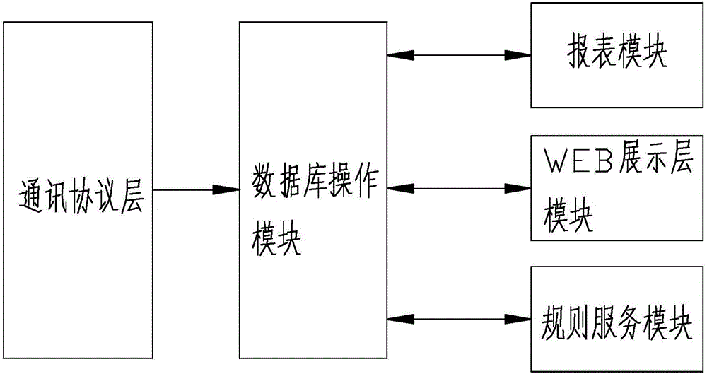
[0023] Such as figure 1 As shown, a Beidou positioning navigation urban pipe network intelligent surveying and mapping inspection and monitoring platform includes a communication protocol layer, a database operation module, a WEB display layer module, a report module and a separate rule service module, forming a Beidou positioning navigation urban pipe network Intelligent surveying and mapping inspection and monitoring platform.

[0024] Such as figure 1 The communication protocol layer shown is based on the communication analysis of the TCP / IP network communication layer, which is used for data interaction between the server and Beidou positioning and navigation surveying and mapping equipment, and pipe network inspection equipment...


PUM


Abstract

The invention relates to a smart surveying and mapping polling and monitoring platform of a Beidou positioning and navigation city pipe network. The smart surveying and mapping polling and monitoring platform comprises a communication protocol layer, a database operation module, a WEB display layer module, a reporting module and an independent rule service module, wherein all modules form the smart surveying and mapping polling and monitoring platform of the Beidou positioning and navigation city pipe network. A GIS (Geographic Information System) electronic map and an automatic pipe network map drawing technology are used, an informationalized means helps a user to efficiently and conveniently carry out management, positioning, design, query, statistics, analysis and plotting on the pipe network, an automatic operation interface can be used for quickly and accurately drawing a pipe network map for the user, and the system of the platform exhibits high instantaneity and openness, can be conveniently connected with a third-party platform, and provides basis data and performs an active function on the enterprise management and the cost control of the user, the smart water service and the smart city of the government and the aspects of the water quality monitoring and control and the water quality traceability of livelihood.

Description

technical field [0001] The present invention relates to the application field of urban pipe network surveying and mapping and inspection, in particular to a Beidou positioning navigation urban pipe network intelligent surveying, mapping, inspection and monitoring platform, automatic calibration of the pipe network of the geographic information system that can be updated in real time, multiple modes of inspection and A system platform for multi-faceted data monitoring. Background technique [0002] As one of the most developed countries in pipeline construction, the United States has gradually established a pipeline information system involving the federal government, state governments and operators since the 1960s. The United States passed the "Pipeline Safety Improvement Act" in 2002, which for the first time explicitly required the implementation of pipeline integrity management procedures in the form of law, and required the establishment of a procedural management system...

Claims


Application Information

Patent Timeline
IPC IPC(8): G06F17/30G06Q10/06G06Q50/26
CPCG06Q10/06312G06Q50/26G06F16/29Y02A20/152
Inventor 黎雄鹰齐全单岳永
Owner 深圳市北斗时空科技有限公司
Learn More