Quick landslide extraction method based on fully polarimetric SAR (synthetic aperture radar) images
A fully polarized, image technology, applied in the field of image processing, which can solve the problems of shadows, overlapping and shrinking, landslide identification and extraction and identification difficulties, etc.
- Summary
- Abstract
- Description
- Claims
- Application Information
AI Technical Summary
Problems solved by technology
Method used
Image
Examples
Embodiment Construction
[0084] Specific embodiments of the present invention will be described below in conjunction with the accompanying drawings, so that those skilled in the art can better understand the present invention. It should be noted that in the following description, when detailed descriptions of known functions and designs may dilute the main content of the present invention, these descriptions will be omitted here.
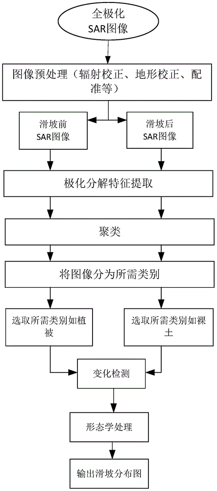
[0085] figure 1 It is a flow chart of the method for extracting large-area rapid landslide information based on SAR images in the present invention.
[0086] In this example, if figure 1 Shown, the landslide information extraction method based on SAR image of the present invention comprises:
[0087] S1. Obtain full polarization original SAR image
[0088] In the specific implementation process, two original full-polarization images to be processed in the same orbit and mode before and after the landslide disaster can be obtained through airborne or spaceborn...
PUM
 Abstract
Description
Claims
Application Information
 - R&D
- Intellectual Property
- Life Sciences
- Materials
- Tech Scout
- Unparalleled Data Quality
- Higher Quality Content
- 60% Fewer Hallucinations
Browse by: Latest US Patents, China's latest patents, Technical Efficacy Thesaurus, Application Domain, Technology Topic, Popular Technical Reports.
© 2025 PatSnap. All rights reserved.Legal|Privacy policy|Modern Slavery Act Transparency Statement|Sitemap|About US| Contact US: help@patsnap.com


