Digital aerial photography measurement method for mapping at ultrahigh magnification

A technology of aerial photography and measurement method, which is applied in the field of aerial photogrammetry, can solve the problems that cannot meet the requirements of large-scale mapping, etc., and achieve the effect of rigorous technical design route, reasonable design and low investment cost

Inactive Publication Date: 2014-07-23
AERIAL PHOTOGRAMMETRY & REMOTE SENSING CO LTD
View PDF4 Cites 15 Cited by
  • Summary
  • Abstract
  • Description
  • Claims
  • Application Information

AI Technical Summary

Problems solved by technology

However, in the actual production of aerial photography mapping, aerial photogrammetry in some areas (such as near the international airport, etc.) is subject to strict airspace control, and the flight height is limited to a certain height, so it cannot meet the requirements of large-scale mapping; in addition, There are still some areas to be measure...

Method used


Image

  • Digital aerial photography measurement method for mapping at ultrahigh magnification
  • Digital aerial photography measurement method for mapping at ultrahigh magnification

Examples


Embodiment Construction

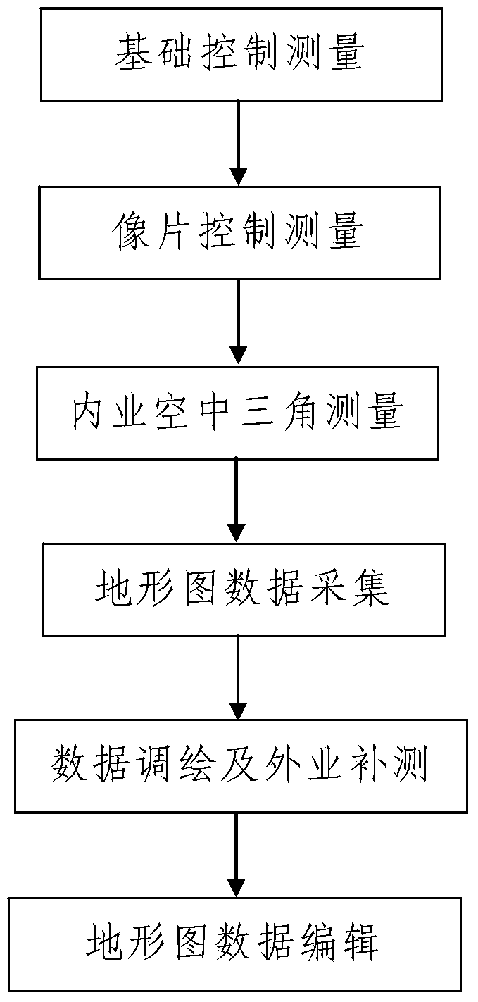
[0036] Such as figure 1 A digital aerial photogrammetry method with ultra-high magnification magnification is shown. The aerial photographic image obtained after aerial photogrammetry of the survey area is an aerial image, and before the digital aerial photogrammetry with ultra-high magnification magnification, Carry out aerial photogrammetry on the survey area and obtain the aerial photographic image of the survey area, the aerial photographic image is a small-scale image; when actually performing digital aerial photogrammetry with ultra-high magnification and magnification, the following steps are included:

[0037] Step 1. Basic control survey: lay out multiple basic control points in the survey area, and establish a survey control network.

[0038] In this embodiment, when the basic control measurement is performed in step 1, the established measurement control network needs to conduct joint measurement with multiple high-level national control points near the measurement ...


PUM


Abstract

The invention discloses a digital aerial photography measurement method for mapping at ultrahigh magnification. The digital aerial photography measurement method comprises the following steps: firstly, basic control measurement, namely distributing a plurality of basic control points in a measurement area, and establishing a measurement control network; secondly, photo control measurement; thirdly, interior aerial triangulation; fourthly, topographic map data acquisition, namely acquiring data by a method of combining exterior actual measurement with interior acquisition with the following steps: step 401, exterior actual measurement, namely carrying out exterior actual measurement on elevation node points of a ground surface in a measurement area, and step 402, interior data acquisition, namely noting ground objects which cannot meet the mapping precision requirement in a three-dimensional model in the interior data acquisition process; fifthly, data annotation and exterior supplementary measurement; and sixthly, topographic map data editing. The method provided by the invention is simple in step, reasonable in design and convenient to achieve, has a good using effect, and can effectively solve the problem of difficulty in performing large-scale digital mapping by small-scale aerophotographs.

Description

technical field [0001] The invention belongs to the technical field of aerial photogrammetry, and in particular relates to a digital aerial photogrammetry method for superhigh-magnification magnification and mapping. Background technique [0002] In the process of conventional aerial photogrammetry, aerial photography data, measuring instruments and technical support measures are the main factors affecting the accuracy of mapping. For vertical photographic photos taken in flat areas, the photographic scale should be determined according to the accuracy requirements of surveying and mapping topographic maps and the actual needs of obtaining ground information. Generally, the magnification of photographic scales for large-scale maps is within 7 times. The influence of photo resolution, projection difference and photographic scale on elevation accuracy are the main technical issues restricting high-magnification magnification mapping. However, in the actual production of aeria...

Claims


Application Information

Patent Timeline
IPC IPC(8): G01C11/00G01S19/42
CPCG01C11/34G01S19/48
Inventor 白志刚李力朱永福赵节霞
Owner AERIAL PHOTOGRAMMETRY & REMOTE SENSING CO LTD
Why Eureka
Try Eureka