Eureka AIR delivers breakthrough ideas for toughest innovation challenges, trusted by R&D personnel around the world.

Automatic underwater landform detection device applicable to torrent environment

A technology for underwater terrain and detection devices, which is used in measurement devices, mapping and navigation, instruments, etc. to achieve the effects of light weight, simple structure and small size

Active Publication Date: 2013-12-11
BEIJING NORMAL UNIVERSITY
View PDF2 Cites 28 Cited by
  • Summary
  • Abstract
  • Description
  • Claims
  • Application Information

AI Technical Summary

Problems solved by technology

Confined by design ideas and instrument limitations, most of the current underwater topographic measurement devices can only be used in rivers, lakes or reservoirs with gentle water flow and calm water surface. However, some special water conservancy project construction, resource development, flood control and disaster reduction, etc. The task needs to be carried out in the river section with turbulent water flow, which requires a new type of underwater terrain measurement device suitable for rapid current environment

Method used

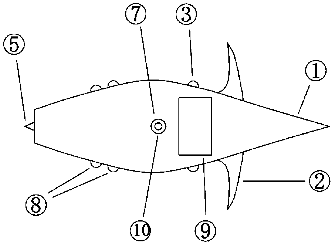

Image

  • Automatic underwater landform detection device applicable to torrent environment
  • Automatic underwater landform detection device applicable to torrent environment
  • Automatic underwater landform detection device applicable to torrent environment

Examples


Embodiment Construction

[0030] See figure 1 , figure 2 , image 3 , the present invention is applicable to an underwater terrain automatic detection device in a torrent environment, which includes a main body ①, a balance wing ②, a laser range finder, a sensor, an ultrasonic depth sounder, a GPS rover station, a GPS reference station, a ruler ⑩, Rudder ⑤, computer chip, data storage unit, LCD display ⑨ and battery. The position connection relationship between them is: the balance wing ②, the laser rangefinder transmitter ③ and the laser rangefinder receiver ④ and the water quality index sensor probe ⑧ are located on both sides of the main body ①, and the LCD display ⑨ is installed on the upper part of the main body ①. It is used to display the data information of the laser rangefinder, ultrasonic depth sounder, sensor and GPS rover; the rudder ⑤ is located at the tail of the main body ①, and after the computer chip determines the position of the device, it converts the information into electrical ...


PUM


Abstract

An automatic underwater landform detection device applicable to a torrent environment comprises a device body, a balanced wing, a laser range finder, a sensor, an ultrasonic depth finder, a GPS moving station, a GPS base station, a ruler, a rudder, a computer chip, a data storage unit, an LCD display screen and a battery, wherein the balanced wing, the emitter and the receiver of the laser distance finder and the probes of the sensor are located on two sides of the device body; the LED display screen is mounted at the upper part of the device body; the rudder is located at the tail part of the device body; the laser distance finder, the ultrasonic depth finder, the sensor, the data storage unit, the battery and the computer chip are sealed in a working cabin of the device body; the GPS moving station is mounted in the working cabin of the device body; an antenna of the GPS moving station is located at the upper part of the device body and is wrapped by a waterproof material; the GPS base station is placed on the open ground of a bank; the transducer of the ultrasonic depth finder is mounted on the external bottom surface of the device body; the ruler is outside the antenna of the GPS moving station. The automatic underwater landform detection device has a wide application prospect in the technical field of underwater landform measurement equipment.

Description

technical field [0001] The invention relates to an underwater terrain automatic detection device suitable for rapid current environment. The device adopts a semi-submersible design. During the process of drifting in the torrent, the DGPS (Difference Global Positioning System) system and the ultrasonic sounding system are used to detect the underwater terrain of the river, and the sensor is used to detect the conventional water quality indicators of the river. The utility model belongs to the technical field of underwater terrain surveying equipment. Background technique [0002] In order to guide the construction of water conservancy projects, the development of river and lake resources, flood control and disaster reduction, etc., underwater topographic survey and underwater topographic map drawing are necessary preparations before the implementation of various water projects. At present, there are many methods for underwater terrain measurement. The general principle is to...

Claims


Application Information

Patent Timeline
Patent Type & Authority Applications(China)
IPC IPC(8): G01C7/00G01D21/02
Inventor 顾洪宾韩升王建伟欧阳威蒋波刘冰
Owner BEIJING NORMAL UNIVERSITY
Why Eureka
Eureka Blog
Learn More