Eureka AIR delivers breakthrough ideas for toughest innovation challenges, trusted by R&D personnel around the world.

Object-oriented remote sensing image building and shade extraction method of remote sensing image building

A remote sensing image, object-oriented technology, applied in image enhancement, image analysis, image data processing, etc., can solve the problems of difficult data acquisition, seldom use of context features, and rare extraction of buildings and their shadows at the same time, so as to achieve accurate High efficiency, reduced workload, and high detection accuracy

Active Publication Date: 2013-09-04
WUHAN UNIV OF TECH
View PDF2 Cites 31 Cited by
  • Summary
  • Abstract
  • Description
  • Claims
  • Application Information

AI Technical Summary

Problems solved by technology

[0005] (2) Use the height information of buildings such as DSM, LIDAR, stereo image pair images and other height data to assist the extraction of buildings, but these data are often not easy to obtain, so they will be limited by data sources
[0008] In the process of extracting buildings, the previous object-oriented methods paid more attention to their spectral and spatial features, but less used their contextual features, and there were few methods for extracting buildings and their shadows at the same time. Although Zhou Yanan [Zhou Yanan, Shen Zhanfeng, Luo Jiancheng, Chen Qiuxiao, Hu Xiaodong, Shen Jinxiang, 2010. Object-oriented urban building extraction under the aid of shadows. Geography and Geographic Information Science, 37-40.] and [Zhou Xiaocheng, 2008.12. High-resolution satellite image building recognition method combined with object relationship features. Remote sensing of land and resources.], but the potential of contextual relations is still not fully exploited, especially for each object In order to effectively solve the "hole" phenomenon inside the building and its shadow and obtain a smoother edge, etc.

Method used


Image

  • Object-oriented remote sensing image building and shade extraction method of remote sensing image building
  • Object-oriented remote sensing image building and shade extraction method of remote sensing image building
  • Object-oriented remote sensing image building and shade extraction method of remote sensing image building

Examples


Embodiment Construction

[0041] The present invention will be further described below in conjunction with the embodiments and accompanying drawings, but the present invention is not limited.

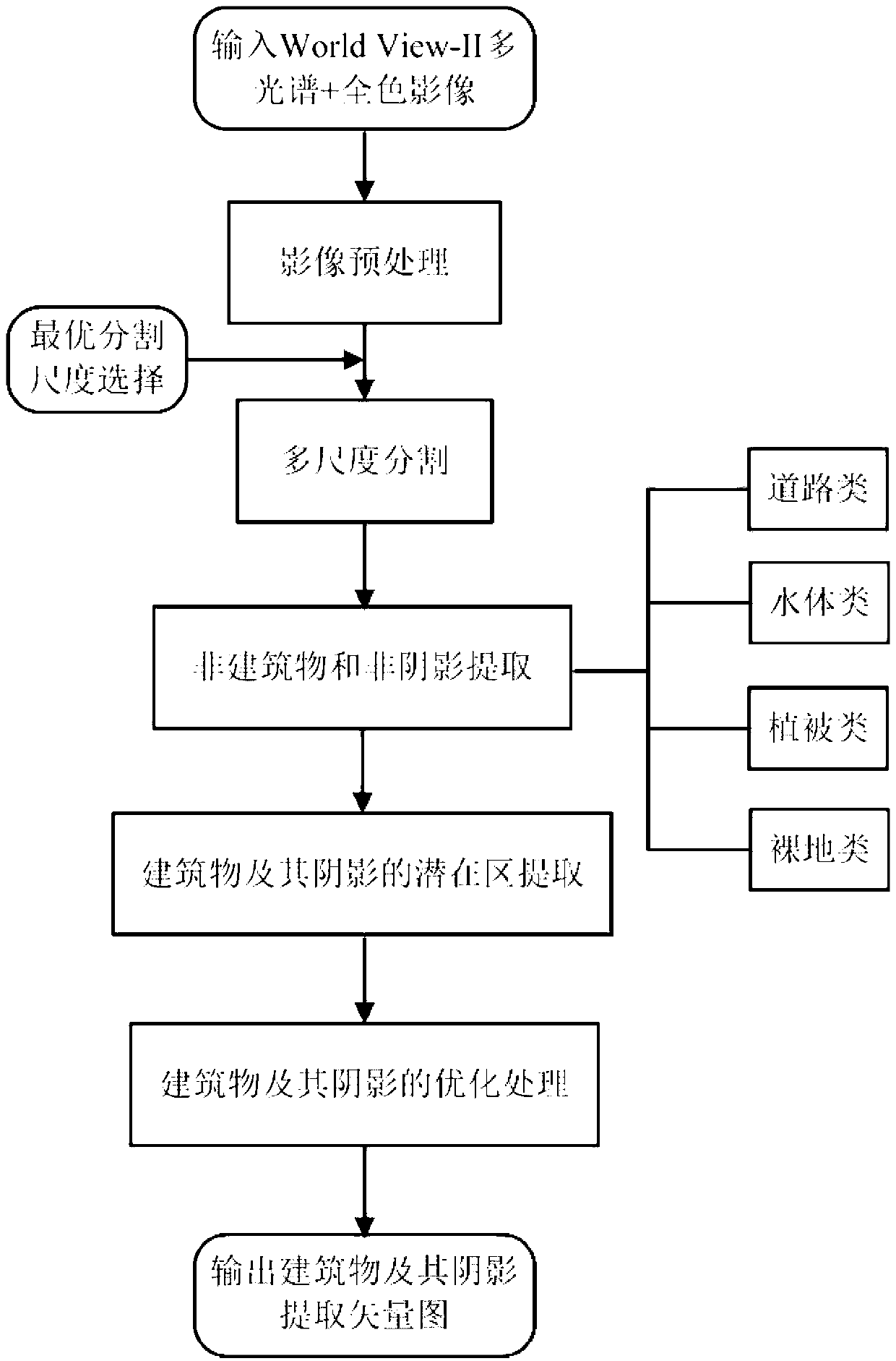
[0042] refer to figure 1 , is the flow chart of the present invention for extracting buildings and their shadows from a high-resolution remote sensing image of a certain research area in Optics Valley, Wuhan, including the following steps:

[0043] 1. Image preprocessing

[0044] The present invention selects a high-resolution remote sensing image in the Optics Valley area of ​​Wuhan City. This data is a remote sensing image taken by the World View-II satellite on July 29, 2011, wherein multi-spectral bands (including blue, green, red, Near-infrared four bands) images have a spatial resolution of 2m, and panchromatic band images have a spatial resolution of 0.5m. The image has been radiatively and geometrically corrected, and has a geographic reference system. According to the specific conditions of the study ...


PUM


Abstract

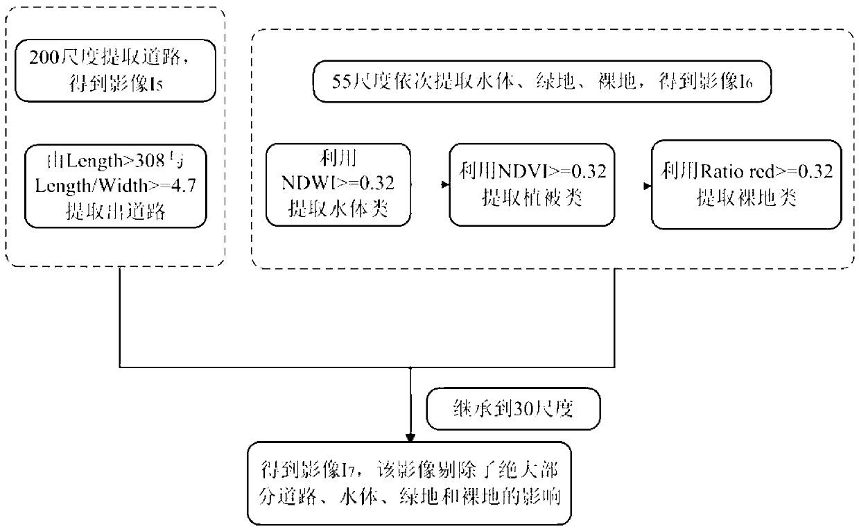
The invention relates to an object-oriented remote sensing image building and a shade extraction method of the remote sensing image building. The method comprises the following steps that the images are preprocessed; the multi-scale division is carried out, and an image scale layer corresponding to the optimum division size of a ground object is selected; non-buildings and non-shades (roads, water bodies, vegetation and bare land) are extracted, and images comprising buildings and the shade candidate object regions are obtained; shade primary extraction is carried out by using spectrum characteristics, the nearest classifier is adopted, a characteristic space is built by combining with the spectrum characteristics, the building primary extraction is carried out, and building potential region and a shade potential region are obtained; and buildings and shades of the buildings are obtained by adopting optimization processing methods of space characteristics, context relationship, smoothening and the like. The object-oriented remote sensing image building and the shade extraction method can effectively solve the problem of confusion among the buildings, the roads and the bare land as well as between the shades of the buildings and the water bodies, the extraction precision of the buildings and the shades of the buildings is high, the process flow is simple, and a certain practical value is realized in the work of basic data updating, urban planning, urban disaster prevention and reduction in the urban construction.

Description

technical field [0001] The invention relates to the field of remote sensing technology object information extraction, in particular to an object-oriented remote sensing image building and its shadow extraction method. Background technique [0002] Buildings are the main part of urban high-resolution remote sensing images, and the acquisition of buildings and their shadow information is of great significance for urban planning, urban disaster prevention and mitigation, and basic data update in urban construction. Remote sensing technology provides a new technical means for the extraction of buildings and their shadow information by virtue of its characteristics of large-area synchronous observation, high timeliness, and economy. With the wide application of high-resolution remote sensing images, the spectrum, shape, texture and other information of ground objects on the images are more obvious, which provides a rich data source for the identification of ground objects. In rec...

Claims


Application Information

Patent Timeline
IPC IPC(8): G06T7/00G06T5/00
Inventor 吴浩程志萍徐晨晨宋冰崔诗雨
Owner WUHAN UNIV OF TECH
Why Eureka
Eureka Blog
Learn More