Radiation Correction Method for Remote Sensing Image
A remote sensing image and radiometric correction technology, applied in the field of remote sensing image processing, can solve problems such as over-correction
- Summary
- Abstract
- Description
- Claims
- Application Information
AI Technical Summary
Problems solved by technology
Method used
Image
Examples
Embodiment 1
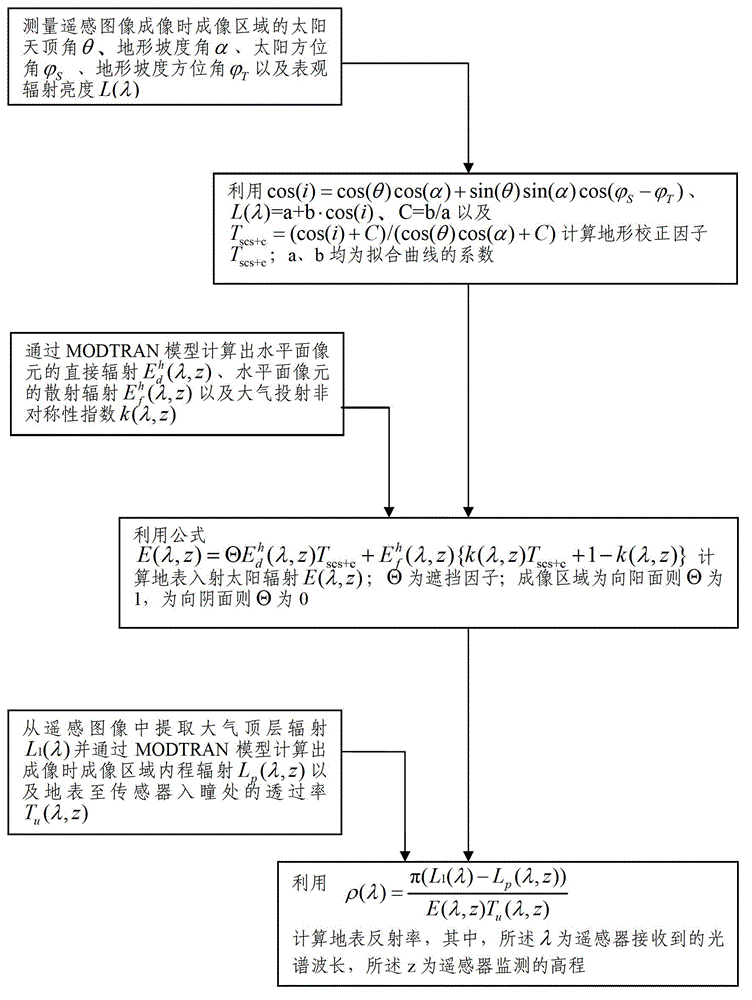
[0031] like figure 1 As shown, the remote sensing image radiation correction method in this embodiment includes the following steps:
[0032] Measure the solar zenith angle θ, terrain slope angle α, and solar azimuth angle of the imaging area terrain slope azimuth And the apparent radiance L(λ) of the terrain relief area;
[0033] use the formula L(λ)=a+b cos(i), C=b / a and T scs+c =(cos(i)+C) / (cos(θ)cos(α)+C) Calculate terrain correction factor T scs+c ; i is the relative incidence angle of the sun in the imaging area; a and b are the values of a and b that can be calculated by linear regression;
[0034] Calculation of direct radiance of horizontal plane pixel by MODTRAN model Diffuse radiance of cells in the horizontal plane and the atmospheric projection asymmetry index k(λ, z);
[0035] use the formula E ( λ , z ) = Θ E d ...
Embodiment 2
[0042] The radiometric correction method for remote sensing images in this embodiment includes the following steps:
[0043] Measure the solar zenith angle θ, terrain slope angle α, and solar azimuth angle of the imaging area and terrain slope azimuth And the apparent radiance L(λ);
[0044] use L(λ)=a+b cos(i), C=b / a, T scs+c =(cos(i)+C) / (cos(θ)cos(α)+C) Calculate terrain correction factor T scs+c ;
[0045]Calculate the direct radiance of the horizontal plane pixels in the imaging area by the MODTRAN model (atmospheric radiative transfer model) and the diffuse radiation of the pixels in the horizontal plane Atmospheric projection asymmetry index k(λ, z) and average reflectance ρ of the imaged area adj ;
[0046] where the average reflectance ρ of the imaging area is calculated adj The process is as follows: remove the influence of atmospheric diffuse radiation and path radiation in the radiation of the top layer of the atmosphere (note: atmospheric diffuse radi...
Embodiment 3
[0060] In order to further optimize the calculation of the surface reflectance to achieve the purpose of improving the accuracy of remote sensing images, this embodiment introduces the sky visibility factor V on the basis of any of the above-mentioned embodiments d and terrain visibility factor V t ,details as follows:
[0061] by formula Calculate V d ,
[0062] by formula Calculate V d , due to the introduction of V d and V t but
[0063] E ( λ , z ) = Θ E d h ( λ , z ) T scs + c E f h ( λ , z ) { k ( ...
PUM
 Abstract
Description
Claims
Application Information
 - R&D Engineer
- R&D Manager
- IP Professional
- Industry Leading Data Capabilities
- Powerful AI technology
- Patent DNA Extraction
Browse by: Latest US Patents, China's latest patents, Technical Efficacy Thesaurus, Application Domain, Technology Topic, Popular Technical Reports.
© 2024 PatSnap. All rights reserved.Legal|Privacy policy|Modern Slavery Act Transparency Statement|Sitemap|About US| Contact US: help@patsnap.com


