
Wireless positioning method and system based on digital image identification and retrieve

A digital image and wireless positioning technology, applied in character and pattern recognition, service based on location information, electronic digital data processing, etc.

Inactive Publication Date: 2011-01-12
郑茂
View PDF4 Cites 53 Cited by
  • Summary
  • Abstract
  • Description
  • Claims
  • Application Information

AI Technical Summary

Problems solved by technology

[0024] In order to overcome the deficiencies of the existing known digital image recognition and retrieval, as well as the deficiencies of the existing known position positioning technology services, the present invention discloses a wireless positioning method and system based on digital image recognition and retrieval

Method used


Image

  • Wireless positioning method and system based on digital image identification and retrieve
  • Wireless positioning method and system based on digital image identification and retrieve

Examples


Embodiment Construction

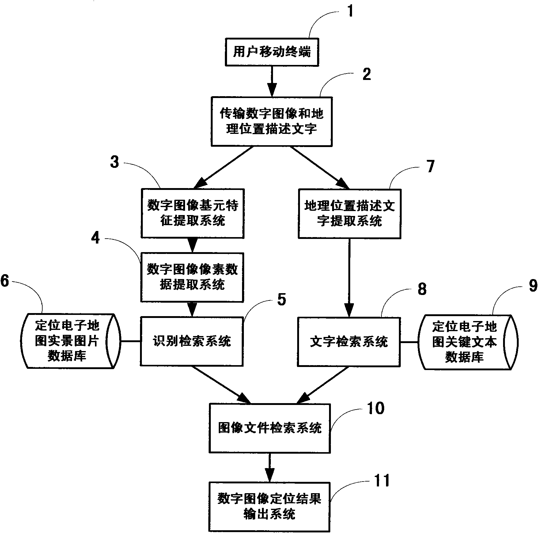
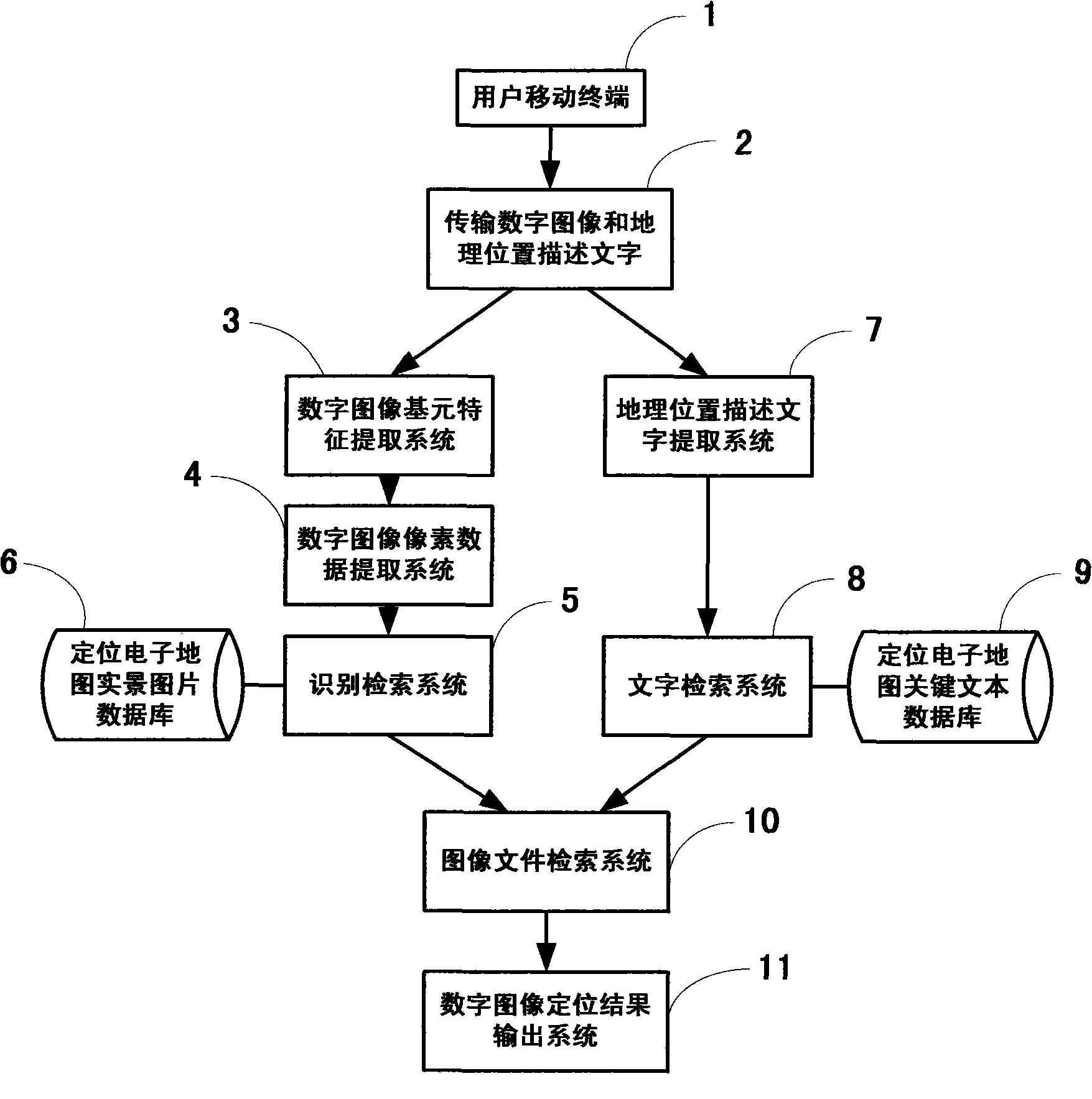
[0049] figure 1 It is a schematic structural diagram of the wireless positioning method and system based on digital image recognition and retrieval in the present invention.

[0050] exist figure 1 Among them, the user takes a digital image of the geographical environment through the mobile terminal device (1), writes the geographical location description text and sends it to the system of the present invention (2), and the system of the present invention establishes a binary value for the digital image received from the user's mobile terminal. Bitmap sequence, the system digital image primitive feature extraction system (3) of the present invention extracts a plurality of primitive features therefrom, and the digital image pixel data extraction system (4) extracts the pixel data of the original digital image according to the relevant range of the corresponding primitive; identification and retrieval The system (5) compares, recognizes and retrieves the results with the posit...


PUM


Abstract

The invention discloses a wireless positioning method and system based on digital image identification and retrieve. A user shoots a located geographic environment digital image through mobile terminal equipment and composes located geographic position descriptive characters to be transmitted to the system; the system establishes a two-value bitmap sequence for a digital image received from a user mobile terminal and extracts a plurality of primitive features from the two-value bitmap sequence (the primitive refers to the key element being different from the pixel, such as segments, curves, closed graphs, grains and the like ) and extracts the pixel data of the original digital image corresponding to the relevant range of the primitive; the location positioning is carried out on the user terminal according to the comparison, identification and retrieve results of the primitive features and the pixel data as well as the live-action digital picture of a positioning electronic map by combining with the identification and retrieve results of the located geographic environment descriptive characters sent by the user, and the relevant positioning information and surrounding geographic information are sent to the user terminal. The method and the system are suitable for all communication network terminal users.

Description

Technical field [0001] The invention discloses a wireless positioning method and system based on digital image recognition and retrieval. In particular, the recognition of digital images in the present invention is based on binary bitmaps, primitives and pixels, and the features of indexed digital images are accurate, the amount of data is small, and the speed of recognition and retrieval is fast. Based on the digital image primitive features and pixel data obtained from the user terminal, identify, retrieve, compare, and analyze the real-scene digital image in the electronic map, and obtain a similar digital image; combined with the geographical location description sent by the user Text information, identifying digital images and related location text data that match the positioning geographic information, obtaining the location location information that best matches the digital image sent by the user terminal, and sending the relevant location data and location information ...

Claims


Application Information

Patent Timeline
IPC IPC(8): H04W4/02G06F17/30G06K9/00
Inventor 郑茂郑琪心郑琪文
Owner 郑茂
Learn More