
Traffic aware lane determination for human driver and autonomous vehicle driving system

a technology of autonomous vehicle and traffic information, which is applied in the direction of traffic control systems, transmissions, vehicle wireless communication services, etc., can solve the problems of increasing traffic congestion in vehicles, slowing down speed, and increasing vehicular queuing, so as to reduce traffic oscillation

Active Publication Date: 2017-06-06
RATNASINGAM SIVALOGESWARAN
View PDF123 Cites 284 Cited by
  • Summary
  • Abstract
  • Description
  • Claims
  • Application Information

AI Technical Summary

Benefits of technology

The patent describes a system, method, and computer software for determining lane information in a road segment to help drivers reach their destination faster. The system receives navigation data from the first vehicle and other vehicles in the same road segment and applies traffic regulation processes to minimize any disruption to traffic flow or congestion. Additionally, the system may receive lane change recommendations based on the second vehicle being a non-automobile vehicle or a vehicle ahead causing a bottleneck in traffic. The system can also selectively transmit lane change recommendations amongst multiple vehicles to minimize traffic oscillation between lanes.

Problems solved by technology

Vehicle traffic congestion is an increasingly problematic issue for authorities and road users.
Traffic congestion leads to a multitude of downstream effects including significant time wastage on the road, slower speed, increased vehicular queuing and as consequence, increases in traffic delay, financial costs and vehicle carbon emissions.
One reason for traffic congestion and delays in reaching a destination is that the driver may not be aware of the correct road layout and the traffic conditions in the lanes ahead.
In particular, drivers may not be aware of congestion in each lane, navigation characteristics and navigation routes of other vehicles.
Without such information, it may be difficult for a driver to find an optimum lane in order to minimize travel time in a multi-lane road.
In the absence of accurate lane information and traffic condition / traffic data in each lane, a driver is likely to remain in the wrong lane or a slow moving lane, which in turn contributes to traffic congestion and delays in reaching the desired destination.
Conventional lane guidance systems suffer from one or more disadvantages in providing a system that efficiently and accurately minimizes travel time for a driver.
For example, in determining an optimum lane to minimize travel time, such systems may not consider parameters such as navigation data of vehicles, location, lane, vehicle types, road map data including traffic restrictions at current time, current traffic conditions, weather conditions, surrounding conditions, driver state, road conditions, driver preference, complexity of road segment, familiarity of the road and the switching cycle and switching period of traffic lights.
In addition, some of the presently available systems may require manual input about traffic related events, which is cumbersome for a user.
In using such a system, it is difficult to find enough volunteers to constantly update traffic related data in all road segments in order to have a comprehensive up-to-date database of live traffic events.
In these systems, redundant or multiple copies of data about the same traffic event may be sent to the server by multiple users, which is inefficient and consumes bandwidth and processing of the user device and the server.
Furthermore, existing systems are limited in their ability to provide comprehensive information to a user.
For example, some existing lane guidance systems provide lane guidance only at intersections and may not take useful information into account when determining a lane guidance such as user preference, lane change restrictions, road rules, road and weather conditions.
Communicating all the dynamic traffic-related data to and from a central server may be difficult or impossible particularly in a dense road network and heavy traffic conditions.
In these systems, the same data may be sent by multiple users, which in turn may waste bandwidth, energy of the device, and consume processing power of a server in filtering out redundant or multiple copies received from multiple users in a congested area.
Transmitting the same data to every vehicle directly in a densely congested area may be inefficient and unnecessary wastage of network resources and device resources.

Method used


Image

  • Traffic aware lane determination for human driver and autonomous vehicle driving system
  • Traffic aware lane determination for human driver and autonomous vehicle driving system
  • Traffic aware lane determination for human driver and autonomous vehicle driving system

Examples


Embodiment Construction

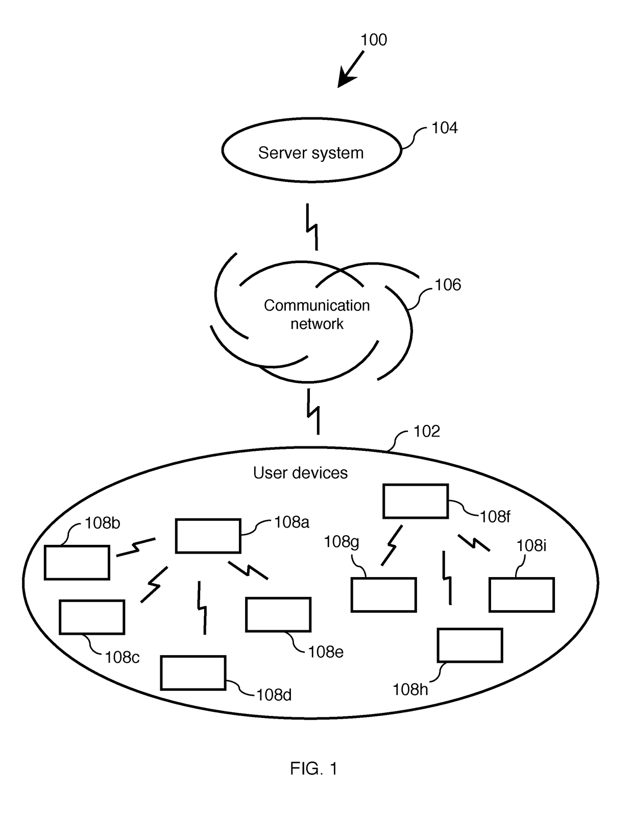
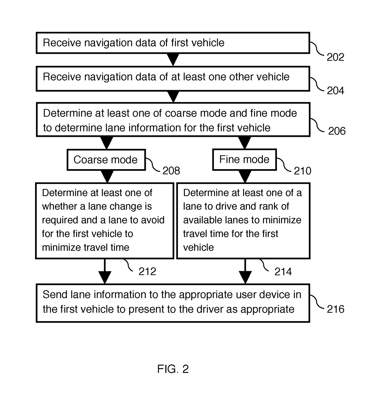
[0071]Described herein is a system, method, and computer program for determining lane information in at least one of coarse mode and fine mode to a first vehicle to minimize travel time in a multilane road segment. Throughout the document, several exemplary embodiments are described based on either a method or a system however, one skilled in the art would be able to implement the invention in at least one of method, system, and computer program product.

[0072]In a preferred embodiment of the invention, the method receives navigation data of a first vehicle and at least one other vehicle that is on the same side of road and same road segment as that of the first vehicle. The method performs at least one operation from a list including (a) determine characteristics of navigation of at least one of the first and the other vehicles, (b) receive type of vehicle of at least one of the first and the other vehicles at the server system, and (c) receive current time. In a further step, the m...


PUM


Abstract

A system, method, and computer program product for determining lane information in a road segment to drive a first vehicle to minimize travel time. According to an embodiment, navigation data of the first vehicle and at least one other vehicle in a road segment is sent to a computer server system via their respective clique leaders through a communication network. The lane information may include whether a change of lane is required, a lane to avoid, an optimum lane, and rank order of drivable lanes according to increasing order of travel time for the first vehicle to minimize travel time. The determined lane information is sent to the appropriate user device through its clique leader. The user device presents the lane information to a human driver and / or autonomous vehicle driving system of the first vehicle appropriately.

Description

FIELD OF THE INVENTION[0001]Described herein is a system and method for determining lane information for a vehicle in order to minimize travel time in a multilane road segment.BACKGROUND OF THE INVENTION[0002]Vehicle traffic congestion is an increasingly problematic issue for authorities and road users. Traffic congestion leads to a multitude of downstream effects including significant time wastage on the road, slower speed, increased vehicular queuing and as consequence, increases in traffic delay, financial costs and vehicle carbon emissions. One reason for traffic congestion and delays in reaching a destination is that the driver may not be aware of the correct road layout and the traffic conditions in the lanes ahead. In particular, drivers may not be aware of congestion in each lane, navigation characteristics and navigation routes of other vehicles. Without such information, it may be difficult for a driver to find an optimum lane in order to minimize travel time in a multi-la...

Claims


Application Information

Patent Timeline
Patent Type & Authority Patents(United States)
IPC IPC(8): G06F19/00G08G1/0968H04L29/08G06G7/70G08G1/01
CPCG08G1/0133H04L67/12G08G1/0112G08G1/0968G08G1/096725G08G1/0145G08G1/096811G08G1/096844G08G1/012G08G1/096716G08G1/096775G08G1/096741G08G1/015G01C21/3658H04W4/44G06V20/588
Inventor RATNASINGAM, SIVALOGESWARAN
Owner RATNASINGAM SIVALOGESWARAN
Learn More