Method of online building-model reconstruction using photogrammetric mapping system

a technology of photogrammetric mapping and building model, applied in the field of building model reconstruction, can solve the problems of inconvenience, incompatibility of two-stage processes with the photogrammetric mapping system, and building reconstruction is hard or unreliable, so as to enhance efficiency and accuracy

Inactive Publication Date: 2013-12-03
NAT CENT UNIV
View PDF2 Cites 5 Cited by
  • Summary
  • Abstract
  • Description
  • Claims
  • Application Information

AI Technical Summary

Benefits of technology

[0006]The main purpose of the present invention is to use a photogrammetric mapping system to digitize 3D segments online for forming 3D models to be compared and edited with an aerial image for enhancing efficiency and accuracy for building-model reconstruction.
[0008]The third purpose of the present invention is to directly connect with 3D segments obtained from the photogrammetric mapping system for forming candidate 3D building models yet with the first priority of candidate output after evaluation to save time for manual interpretation and, when difficult interpretation or topological error happens, the candidates can be used to be compared with an aerial image.
[0009]The fourth purpose of the present invention is to digitize 3D segments in the photogrammetric mapping system to directly form 3D building models for enhancing efficiency and accuracy for building-model reconstruction.

Problems solved by technology

It makes the building reconstruction hard or unreliable.
Yet, the 3D building models are not formed online and so inconvenience happens.
Furthermore, the two-stage processes are not compatible with the photogrammetric mapping system.
Moreover, when a building corner is occluded by vegetation, the measured closed roof polygon containing the occluded building corner is not reconstructed.
Hence, height information loss happens and results in difficult interpretation and topological error on reconstructing 3D building models.
When only 3D solid models or 3D polygons can be digitized, problems may occur.
Hence, the prior arts do not fulfill all users' requests on actual use.

Method used


Image

  • Method of online building-model reconstruction using photogrammetric mapping system
  • Method of online building-model reconstruction using photogrammetric mapping system
  • Method of online building-model reconstruction using photogrammetric mapping system

Examples


Embodiment Construction

)

[0028]The following description of the preferred embodiment is provided to understand the features and the structures of the present invention.

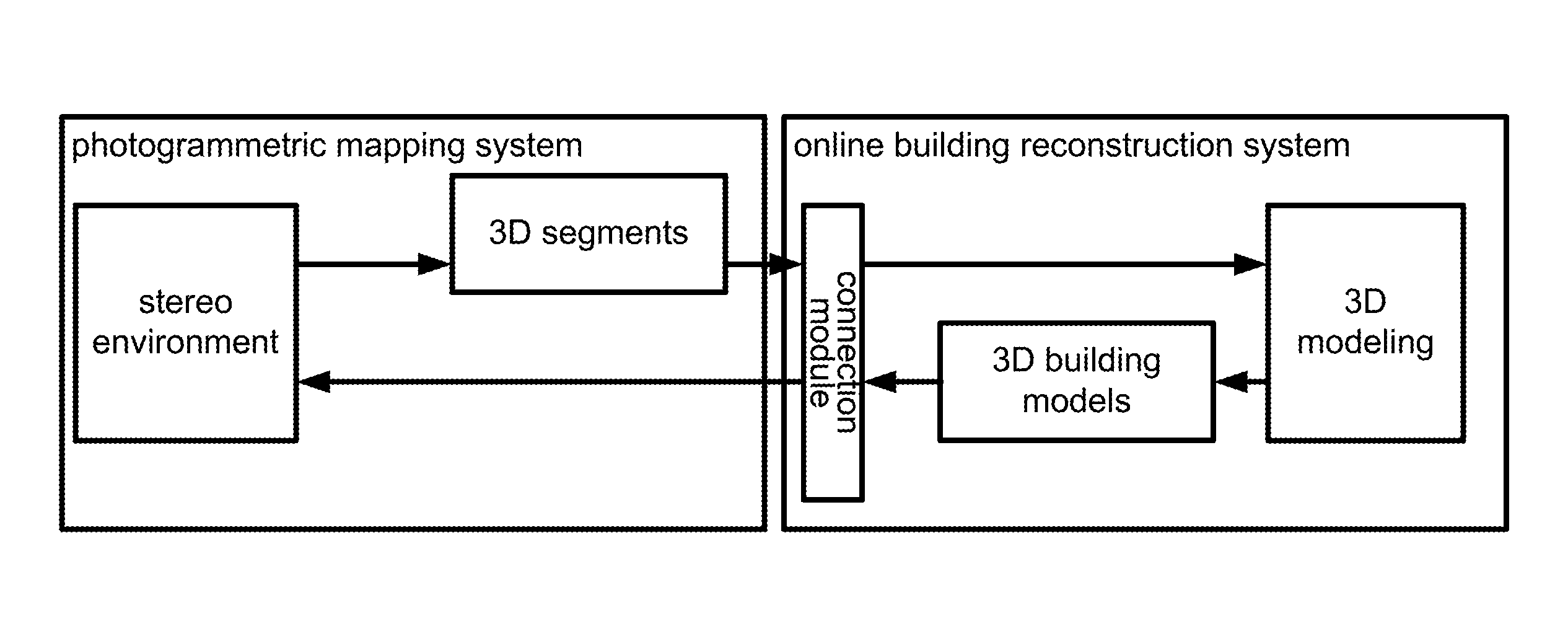
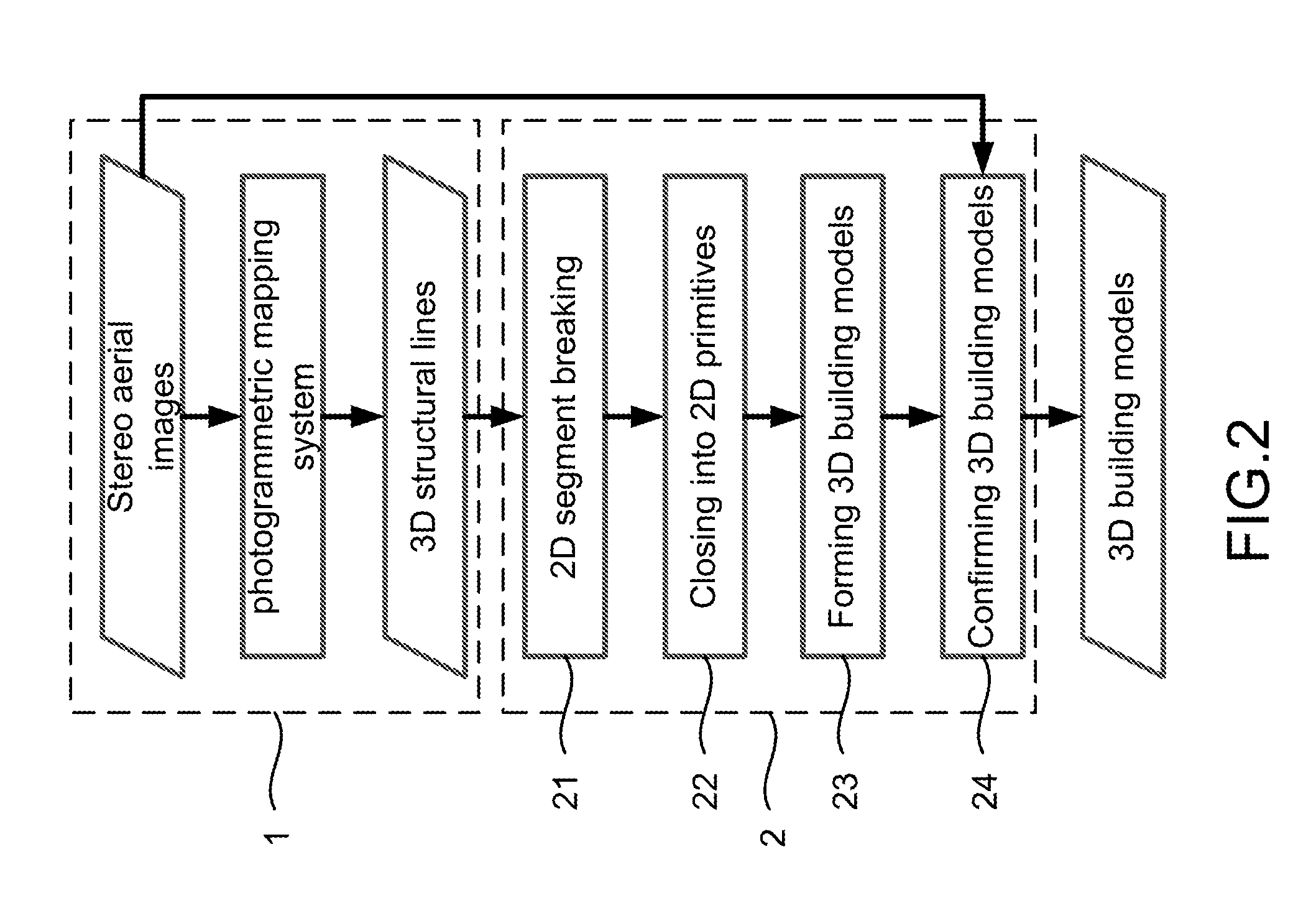
[0029]Please refer to FIG. 1 and FIG. 2, which are a structural view and a flow view showing a preferred embodiment according to the present invention. As shown in the figures, the present invention is a method of online building-model reconstruction using a photogrammetric mapping system, where a photogrammetric mapping system is used to measure 3D segments for constructing 3D building models to be compared and edited with an aerial stereo image for improving efficiency and accuracy for the building-model reconstruction. A computer-aided design (CAD) software MicroStation is used for developing the present invention, where the software can be coordinated with different photogrammetric mapping systems for easy digitization. The present invention comprises the following steps:

[0030](a) Online-accessing 3D structural lines 1: A photogrammetric...


PUM


Abstract

The present invention combines an existing photogrammetric mapping system for building-model reconstruction. Topographic maps and models are produced simultaneously. The models can be edited along with aerial images in an online environment. Thus, efficiency and accuracy for building-model reconstruction are increased.

Description

TECHNICAL FIELD OF THE DISCLOSURE[0001]The present invention relates to building-model reconstruction; more particularly, relates to using a photogrammetric mapping system to digitize 3D line segments online for forming 3D models to be compared and edited with stereo aerial images for enhancing efficiency and accuracy for building-model reconstruction.DESCRIPTION OF THE RELATED ARTS[0002]Three-dimensional (3D) data manipulation is a major tendency in geographic information systems (GIS). The building-model reconstruction is an important task among others. The data used include aerial images and light detection and ranging (LIDAR) point clouds for building reconstruction. Aerial images are favorable in terms of better spatial resolution in photogrammetry. Although conventional photogrammetric mapping is performed in a 3D environment, 2D vector data is recorded for traditional topographic map in many countries. Thus, the mapping process would not record the height information of man-m...

Claims


Application Information

Patent Timeline
Patent Type & Authority Patents(United States)
IPC IPC(8): G06G7/48
CPCG01C11/06G06F17/5004G06F30/13
Inventor CHEN, LIANG-CHIENTEO, TEE-ANNCHANG, WEN-CHI
Owner NAT CENT UNIV
Why Eureka
Try Eureka