
Sensor fusion system and method for estimating position, speed and orientation of a vehicle, in particular an aircraft

a technology of fusion system and fusion method, which is applied in the direction of distance measurement, navigation instruments, instruments, etc., can solve the problems of increasing system cost and weight, only applicable to linear or linear dynamical systems, and used in certain cases

Inactive Publication Date: 2011-06-28
INST NACIONAL DE TECNICA AEROESPACIAL
View PDF4 Cites 43 Cited by
  • Summary
  • Abstract
  • Description
  • Claims
  • Application Information

AI Technical Summary

Benefits of technology

This method provides a globally convergent and computationally efficient solution for estimating vehicle position, velocity, and orientation, even with low-cost sensors, by using a control law that corrects angular velocity measurements, resulting in stable direction cosine matrix and Euler angle estimations.

Problems solved by technology

1. Inertial Navigation System or INS: Integrates the angular accelerations and velocities provided by an Inertial Measurement Unit (IMU) to calculate the position, velocity and orientation of the vehicle. Since this integration is neutrally stable, errors accumulate and the obtained solutions quickly diverge unless very high quality sensors are used, increasing system cost and weight.
The drawback is that it is applicable only to linear or linearized dynamical systems.
Therefore it can only be used in certain cases.
The drawback is that linearization leading to the error model means that the global convergence is not assured and spurious updates could lead to system divergence; furthermore, like all Kalman filters its design implies knowledge of statistics of both the measurement noise and process noise and that these noises are white, Gaussian and non-correlated noises, which in the case of low-cost sensors occurs rather infrequently.
Its computational cost ranges between moderate to high, depending on the size of the state vectors and measurements.
It has a higher risk of divergence than the standard Kalman because the covariance equations are based on the linearized system and not on the real non-linear system.
Its asymptotic local stability has been proven, but its global stability cannot be assured.
In addition to sharing with the remaining Kalman filters the need to know the noise and measurement statistics, its computational cost is high.

Method used


Image

  • Sensor fusion system and method for estimating position, speed and orientation of a vehicle, in particular an aircraft
  • Sensor fusion system and method for estimating position, speed and orientation of a vehicle, in particular an aircraft
  • Sensor fusion system and method for estimating position, speed and orientation of a vehicle, in particular an aircraft

Examples


Embodiment Construction

[0120]As an example of the best way to carry out the invention to practice, the embodiment of a sensor fusion unit is shown for a flight control system of a short-mid range, low speed unmanned aerial vehicle (UAV) without this ruling out the possibility of there being other implementations.

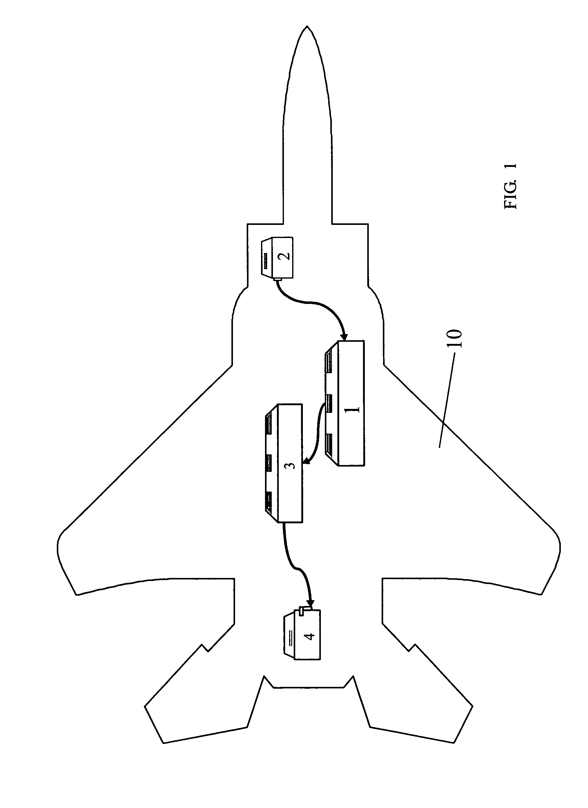
[0121]FIG. 1 shows the flight control system in an unmanned aerial vehicle 10 consisting of sensors 2, the system 1 of the invention, a control and guidance system 3 and actuators 4. The system 1 of the invention supplies information on the attitude, velocity and position to the control and guidance system 3, which in turn provides the corresponding information to the actuators 4 of the aircraft. The information provided by a group of sensors, which in FIG. 1 are depicted together in a single box as sensors 2, are inputs of the system of the invention.

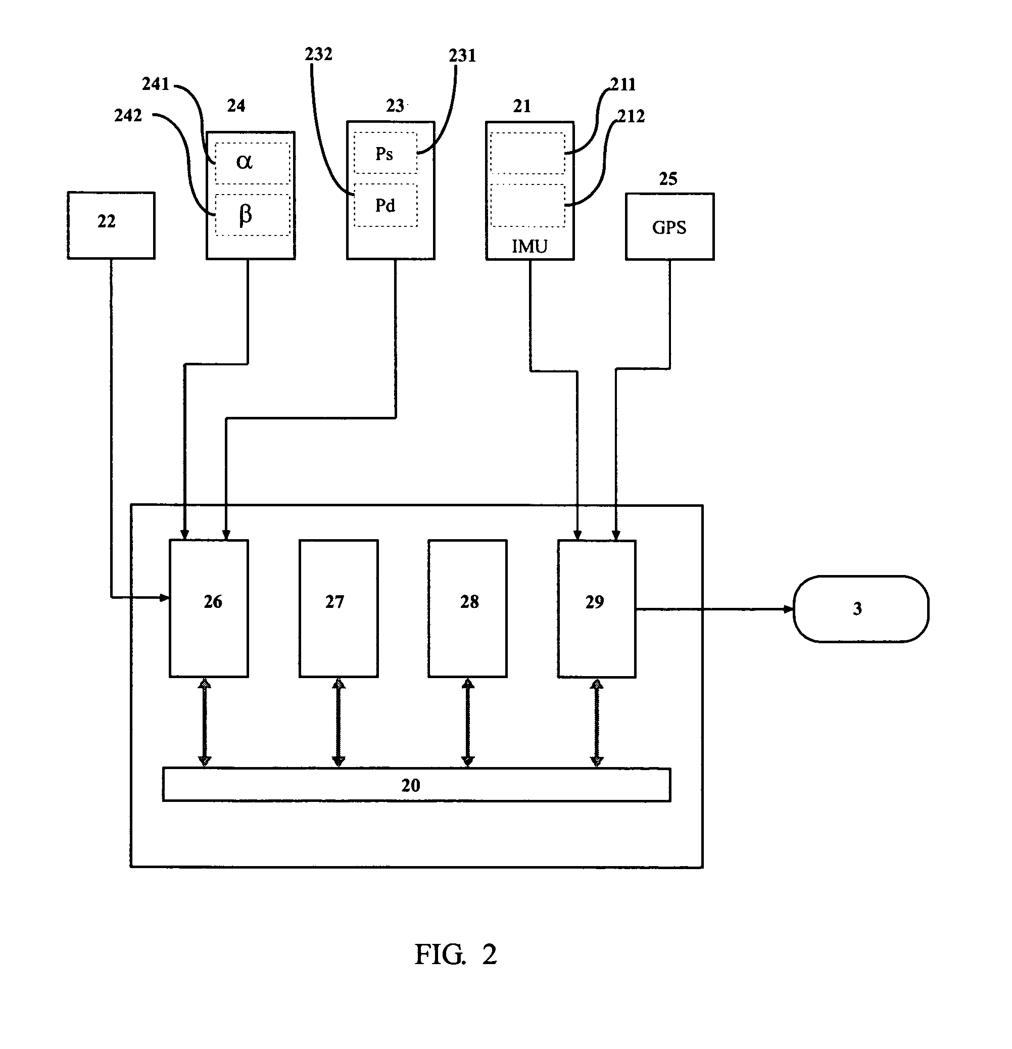
[0122]FIG. 2 details said sensors which are:

[0123]an Inertial Measurement Unit (IMU) 21, including a group of three gyroscopes 211 and three acceler...


PUM


Abstract

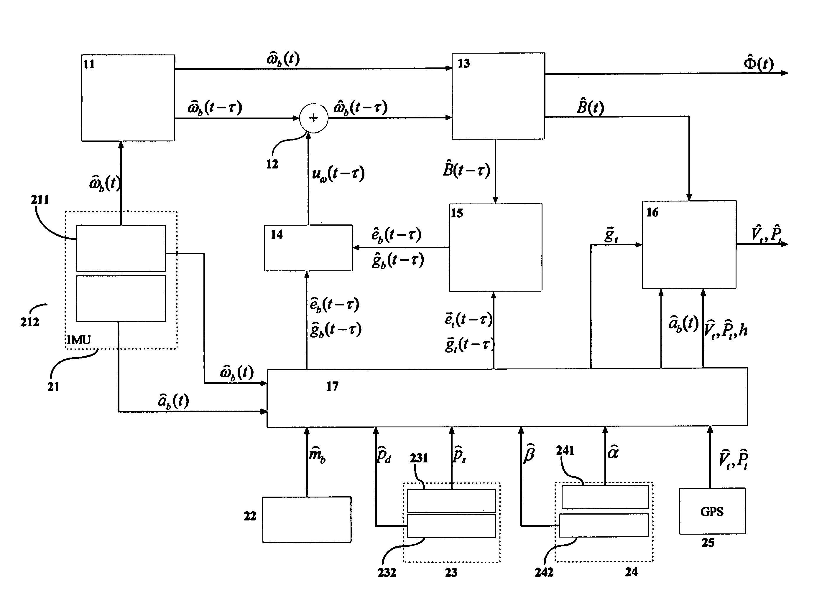
This invention relates to a system for estimating the position, velocity and orientation of a vehicle, by determining the components of two noncollinear constant unit vectors b,b according to vehicle body axes; and determining the components of the noncollinear constant unit vectors {right arrow over (g)}t,{right arrow over (e)}t according to Earth's axes. The system further determines the three components of angular velocity b of the vehicle in body axes; corrects the angular velocity b with a correction uω and obtains a corrected angular velocity {circumflex over (ω)}b=b+uω; a control module implementing a control law to calculate the correction uω, where the control law is:uω=σ(b×ĝb+b×êb)  [1]where σ is a positive scalar,such that upon using the corrected angular velocity {circumflex over (ω)}b=b+uω as input to a module for integrating the kinematic equations, the latter are stable in the ISS sense and the error in the estimation of the direction cosine matrix {circumflex over (B)} and of the Euler angles {circumflex over (φ)} is bounded.

Description

BACKGROUND OF THE DISCLOSURE[0001]1. Field of the Disclosure[0002]This invention relates to a method and system for integrating data from different sensors and estimating the position, velocity and orientation of a vehicle. It is particularly suited to being applied to Unmanned Aerial Vehicles (UAV) incorporating low-cost sensors for:[0003]determining the attitude and orientation of the vehicle;[0004]determining its position and velocity;[0005]navigating during limited time periods without GPS.[0006]The invention is comprised within the fields of sensor fusion, attitude determination and inertial navigation.[0007]2. Description of Related Art[0008]There are several methods for estimating the position, velocity and orientation of a vehicle:[0009]1. Inertial Navigation System or INS: Integrates the angular accelerations and velocities provided by an Inertial Measurement Unit (IMU) to calculate the position, velocity and orientation of the vehicle. Since this integration is neutrally s...

Claims


Application Information

Patent Timeline
Patent Type & Authority Patents(United States)
IPC IPC(8): G01C21/26G06F19/00G01C3/08G01C21/16G05D1/00G05D1/10
CPCG01C3/08G05D1/101G01C21/16G05D1/00
Inventor PARRA CARQUE, SERGIO DE LA
Owner INST NACIONAL DE TECNICA AEROESPACIAL
Learn More