Improved real-time weather forecasting for transportation systems

Active Publication Date: 2019-11-07
REMOTE SENSING SOLUTIONS INC
View PDF2 Cites 23 Cited by
  • Summary
  • Abstract
  • Description
  • Claims
  • Application Information

AI Technical Summary

Benefits of technology

The technology described in this patent reduces the time it takes to process data. This means that the time between processing events, sometimes referred to as the cadence, is very short. This can be done by making the intervals between data collection very short, or by reducing the time it takes to process each piece of data.

Problems solved by technology

Fog events can have notable negative impacts on industry and safety, for example by impairing visibility at airports, thereby making takeoffs and landings difficult or impossible and causing flight cancellations and delays.
Fog events impair visibility on surface roadways, causing surface transportation delays and contributing to motor vehicle accidents.
Fog also negatively impacts water-borne shipping and transport.
These known methods are capable of detecting fog where observers and dedicated instruments are located but fail to detect or predict fog beyond an effective instrument or observer range.
However, levels of RF attenuation caused by fog could also be caused by atmospheric phenomena other than fog.
Therefore, models and algorithms of the known art can fail to distinguish RF attenuation due to fog from attenuation due to rain, a high local atmospheric water density in the absence of fog, or a combination of fog and another atmospheric hydrometer such as a light rain.
Known fog detection systems are limited in their ability to accurately detect fog, and to determine fog-dependent changes in visibility, at locations outside the range of direct observation.
Previous weather forecasting systems based upon RF attenuation are known, but do not support the processing of RF attenuation from satellite-based microwave links.
In particular, the use of satellite microwave links for both geostationary and low earth orbit satellites is not well understood.
The current computational load for calculating the orbital mechanics, the earth station-satellite microwave link paths, and the calculations required to reduce this information into usable weather data are not feasible for short term forecasting needs.
These models and algorithms previously have been incapable of determining whether particular attenuation measurements are caused by fog or by some other type of hydrometer or atmospheric interference.
Known weather information systems are also limited in their ability to process and integrate high sampling frequency data, such as information collected from onboard sensors of millions of vehicles at collection intervals measured in seconds or minutes.
Typically, the temporal accuracy of existing weather system supporting the transportation industry is approximately 20 minutes, causing low fidelity forecasts that do not take into account more accurate data collected from vehicles and other high frequency data sources.
Also, current forecasting systems are unable to keep up with the large data rates that can be collected from these high frequency data sources, causing the forecasting systems to slow down either during data collection as large number of input data points are collected and processes, or during the forecast calculation when millions of real time data points are being applied to the forecast models.
Rapidly changing weather phenomena, including fog and squall lines, disproportionally affect transportation systems due to the transportation systems' reliance upon known weather in operational planning.
Weather forecasts that lag real time or are not rapidly updated when the weather rapidly changes further this disruption.
Taken together, these challenges mean that existing systems fail from an information handling perspective in their ability to support real-time prediction of precipitation amounts.
Additionally, prior art approaches collectively demonstrate notable deficiencies when applied to input data that require complex processing in order to transform the data into usable weather data or to input data comprising high frequency sensor readings.
First, they are hindcast model development techniques, which provide, by definition, a forecast after the event has happened.
They are also limited with respect to the data sources used, as these data sources have built in inaccuracies due to limits in the underlying models, and are based upon unchanging data sources.
Accordingly, they are non-generalizable and are insufficient to support real-time analysis and prediction of weather-related phenomena.

Method used


Image

  • Improved real-time weather forecasting for transportation systems
  • Improved real-time weather forecasting for transportation systems
  • Improved real-time weather forecasting for transportation systems

Examples


Embodiment Construction

6.1 Overview

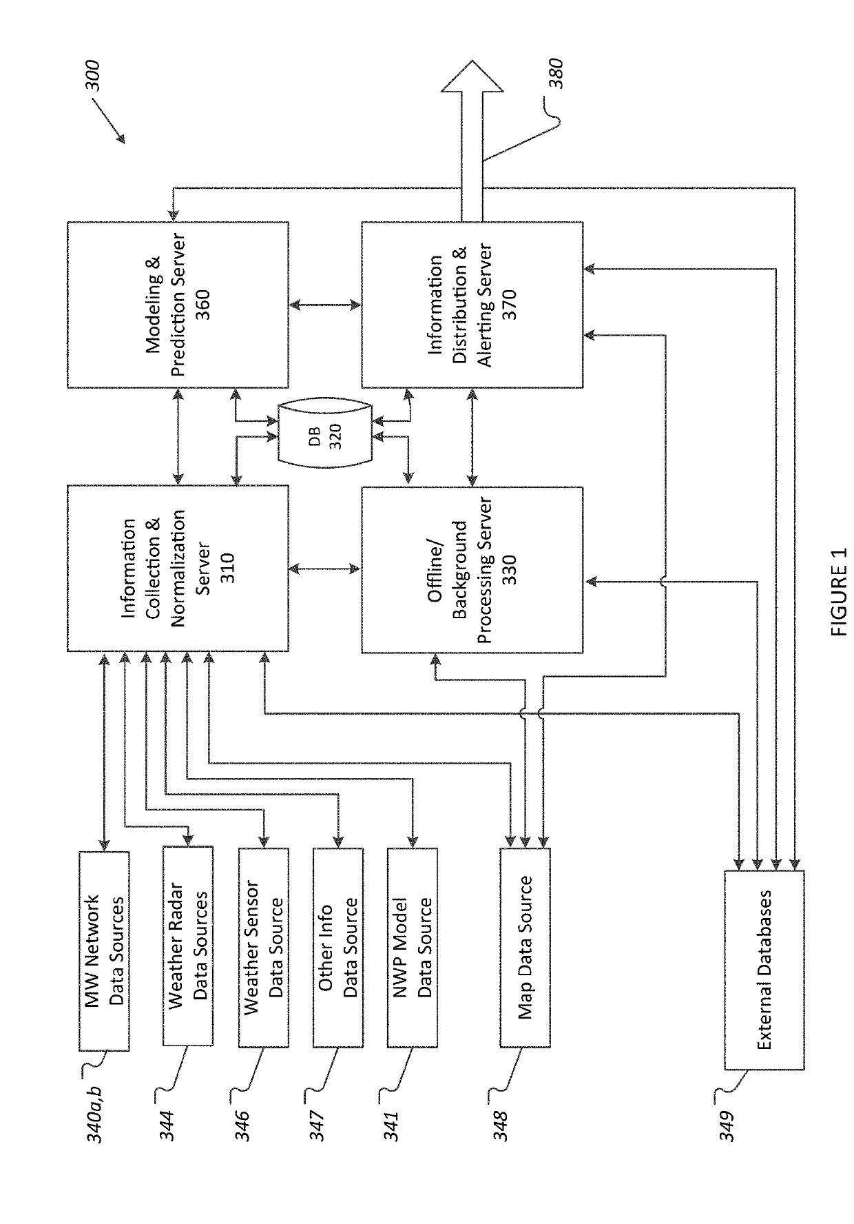
[0032]The systems and methods described herein provide an improved mechanism for collecting information from a diverse suite of sensors and systems, calculating the current precipitation, atmospheric water vapor, atmospheric liquid water content, or precipitable water and other rapidly changing atmospheric-based phenomena, for example presence and intensity of fog, based upon these sensor readings, predicting future precipitation and atmospheric-based phenomena, and estimating effects of the atmospheric-based phenomena on visibility, for example by calculating runway visible range (RVR) estimates and forecasts based on the atmospheric-based phenomena. The described system and methods provide for faster updates and use of rapidly updated collected data sets, significant accuracy improvements and improved forecasting accuracy, and real-time projections.

[0033]“Real time” meteorology equipment, such as weather radar, provides precipitation maps showing precipitation intensit...


PUM


Abstract

Improved mechanisms for collecting information from a diverse suite of sensors and systems, calculating the current precipitation, atmospheric water vapor, atmospheric liquid water content, or precipitable water and other atmospheric-based phenomena, for example presence and intensity of fog, based upon these sensor readings, predicting future precipitation and atmospheric-based phenomena, and estimating effects of the atmospheric-based phenomena on visibility, for example by calculating runway visible range (RVR) estimates and forecasts based on the atmospheric-based phenomena.

Description

CROSS REFERENCE TO RELATED U.S. PATENTS & PATENT APPLICATIONS[0001]The present application is related to U.S. Pat. No. 10,078,155 issued Sep. 18, 2018, which is incorporated herein by reference in its entirety and for all purposes.[0002]The present application claims benefit of U.S. Provisional Patent Application No. 62 / 581,531 (Docket No. CLI-003PR) filed Nov. 3, 2017, and U.S. Provisional Patent Application No. 62 / 609,096 (Docket No. CLI-004PR) filed Dec. 21, 2017, both of which are incorporated herein by reference in their entirety and for all purposes.[0003]The present application is also co-filed with IMPROVED REAL-TIME DATA PIPELINE TECHNIQUES FOR IMPROVING A FAST WEATHER FORECASTING SYSTEM, U.S. patent application Ser. No. ______ (Docket No. 6748-11) filed Nov. 5, 2018, which is incorporated herein by reference in its entirety and for all purposes. This co-filed application and patents issuing therefrom is / are referred to below as “the co-filed application”.COPYRIGHT NOTICE[0...

Claims


Application Information

Patent Timeline
IPC IPC(8): G08G5/00G01W1/10G01W1/02G08G5/02
CPCG08G5/0065G01W1/02G08G5/025G08G5/0091G01W1/10G01W2001/003G01W2001/006G01W2203/00Y02A90/10G06N5/00G01W1/00G01W2201/00G06N20/00H04W84/005
Inventor ELKABETZ, SHIMONRIBNIK, JACOBZLOTNIK, ITAIGOFFER, REINOSSENSON, NIRROTHENBERG, DANIEL ALEXANDERGINTER, KARL
Owner REMOTE SENSING SOLUTIONS INC
Why Eureka
Try Eureka