Multi-beam bathymetric chart construction method based on submarine digital depth model feature extraction

a multi-beam bathymetric chart and feature extraction technology, applied in wave based measurement systems, using reradiation, instruments, etc., can solve the problems of missing submarine topographic feature points and difficult to extract features, etc., to achieve important practical application value, large volume of multi-beam depth data

Inactive Publication Date: 2015-02-05
SECOND INST OF OCEANOGRAPHY MNR
View PDF3 Cites 16 Cited by
  • Summary
  • Abstract
  • Description
  • Claims
  • Application Information

AI Technical Summary

Benefits of technology

[0010]1.1) applying tide correction, draft correction and sound velocity correction to the raw multi-beam echo sounding data set Raw={rawi}i=1,n, eliminating effects of water level and sound velocity on multi-beam echo sounding (MBES), and forming a preliminary processing data set Proc1={proc1i}i=1,n, wherein n is a natural number;
[0011]1.2) building a topographic trend surface, using automatic filtering method to process Proc1={proc1i}i=1,n, eliminating effects of gross errors on MBES, and forming a postprocessing data set Proc2={proc2i}i=1,n,
[0012]1.3) using three-view projection to process Proc2={proc2i}, i=1,n, further eliminating effects of ocean noise of a variety of sources on MBES, and forming a discrete full-beam bathymetric data set Proc3={xi, yi, zi}i=1,m, wherein m is a natural number;
[0040]4.2) if dis=√{square root over ((xi−X1)2+(yj−YJ)2)}{square root over ((xi−X1)2+(yj−YJ)2)}<0.5×grid_d , and dssI,J is identified as 1, using the IDW method, based on the data set Proc3={xi, yi, zi}i=1,m, recalculating the depth value dep_newI,J of grid points of the model DSSM, wherein grid_d is spatial distance between nearest two points, using 0.5×grid_d for re-modeling aims to make value of reconstruction model points close to true depth value, while not using raw sounding data aims to avoid accidental detection error affecting the multi-beam bathymetric chart construction;

Problems solved by technology

Its disadvantage is the sparse of the data which leads to missing submarine topographic feature points.
Both of them are limited in use.
The disadvantage of using grid data directly is that the measured data are not employed; negatively affecting the reliability of the maps; while using the central beam tends to miss the feature depth points of survey lines which need to be identified.

Method used


Image

  • Multi-beam bathymetric chart construction method based on submarine digital depth model feature extraction
  • Multi-beam bathymetric chart construction method based on submarine digital depth model feature extraction
  • Multi-beam bathymetric chart construction method based on submarine digital depth model feature extraction

Examples


example 1

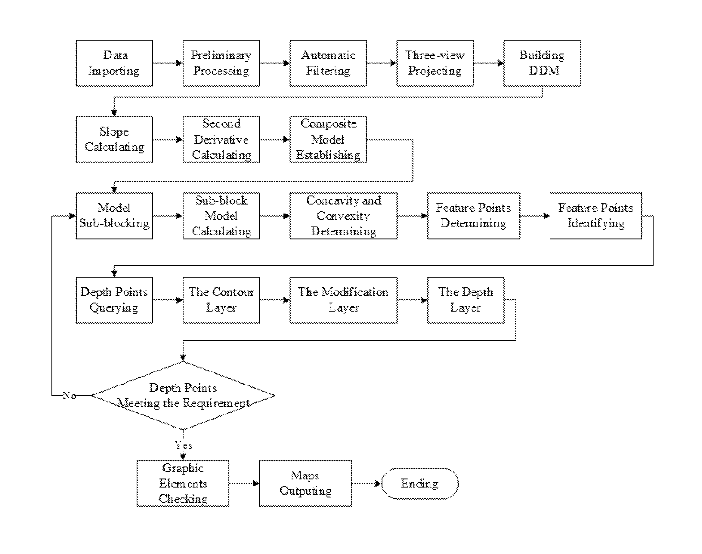
[0057]Multi-beam bathymetric chart construction method based on submarine digital depth model feature extraction, the flowchart in the embodiment illustrated in FIG. 1, comprising steps of:[0058]Step 1 constructing a digital depth model (DDM) based on raw multi-beam echo sounding,[0059]using a multi-beam postprocessing system, processing the raw multi-beam data as following:[0060]1.1) applying tide correction, draft correction and sound velocity correction to the raw multi-beam echo sounding data set Raw={rawi}i=1,n, eliminating effects of water level and sound velocity on multi-beam echo sounding (MBES), and forming a preliminary processing data set Proc1={proc1i}i=1,n, wherein n is a natural number;[0061]1.2) building a topographic trend surface, using automatic filtering method to process Proc1={proc1i}i=1,n, eliminating effects of gross errors on MBES, and forming a postprocessing data set Proc2={proc2i}i=1,n;[0062]1.3) using three-view projection to process Proc2={proc2i}i=1,n,...


PUM


Abstract

The invention discloses a multi-beam bathymetric chart construction method based on submarine digital depth model feature extraction. The method comprises the steps of: constructing a DDM (Digital Depth Model) based on raw multi-beam echo soundings; establishing a slope and second derivative composite model based on the DDM; extracting feature points based on DDM sub-blocks; querying the multi-beam depth based on the feature points; constructing the multi-beam bathymetric chart based on layers.

Description

FIELD OF THE INVENTION[0001]The present invention relates to the field of submarine topography mapping, marine surveying, marine geographic information systems, computer graphics and underwater science.BACKGROUND OF THE INVENTION[0002]Depth annotation is an important part of submarine topography mapping, chart drawing and marine engineering drawing. Bathymetric chart is capable to quantitatively describe topography and geomorphology of submarine, and intuitively reflect the navigation capacity of sea area. Bathymetric chart plays a role that can't be replaced by other charts in scientific research and navigation. The difference between a bathymetric chart and other topographical maps is that the representation of a bathymetric chart mainly relies on depth annotations with subsidiary isobath, combined with substrate annotations. Depth is the main parameter to reflect topographic relief.[0003]The single-beam echo sounding obtains less bathymetric data, and most of raw data are retaine...

Claims


Application Information

Patent Timeline
Patent Type & Authority Applications(United States)
IPC IPC(8): G01V1/38G01V1/32G01V1/34
CPCG01V1/3808G01V1/325G01V1/345G01V1/38G01S15/87G01S15/88
Inventor WU, ZIYINSHANG, JIHONGLI, SHOUJUNZHAO, DINENGZHOU, JIEQIONG
Owner SECOND INST OF OCEANOGRAPHY MNR
Why Eureka
Try Eureka