Geological Exploration Method for Making Plan and Elevation Drawings Directly by Rotational Tin Network and Non-Profiling Method

a technology of rotational tin network and geological exploration method, which is applied in the field of geological exploration method set, can solve the problems of inability to effectively adjust, difficulty in controlling structure, and poor accuracy of geological map, so as to improve the accuracy of contour map and improve the accuracy of overall analysis.

Inactive Publication Date: 2014-03-20
HUANG GUIZHI
View PDF3 Cites 11 Cited by
  • Summary
  • Abstract
  • Description
  • Claims
  • Application Information

AI Technical Summary

Benefits of technology

[0162](1) In the basic unit, comparing with the square network, there are 4 (1+4×0.25+4×0.5) zones controlled by the sampling points of the square network, and there are also 4 (3+4×0.25) zones controlled by rotary network of example 2. But, rotary network can save three drill holes. In whole exploration area, the ratio of solving drill holes of rotary network is,
[0166](4) In matching unit, set the spacing of gird of square is 20 meters, the average length of two adjacent sample points, along the directions of two sides and diagonals of square networks is 12.07 ((10×4+14.148×4)/8). Because of the optimized consideration for multiple directional controlling distances and their mutual echo, the rotary network can make the lengths of two adjacent sample points at respectively 9.13, 10.51, 10.12, 9.15, 13.21, 12.4, 12.9, 12.54, 11.55, 12.52, 8.88, 12.52, 11.55, 8.31,13.21 and 12.4, in which 8 distances are less than the average length 12.07, 6 distances are slightly larger than 12.07, and the remaining 2 distances increase by 0.09 compared to 12.07. The average length is 11.31, which increases by 6% compared to the square network.
[0168](5) From a wide range, form the oval complex network interspersed and staggered along two diagonal directions; it can control linear and planar changes well along multiple directions, and the zones respectively surrounded by the longer sides and shorter sides, are adjacent or surrounded. Because the trends of changes are gradual, the detailed changed laws of the zone surrounded by the shorter sides can be used to distinguish that of the longer sides and

Problems solved by technology

The existing geological exploration methods, of using the square/rectangle/triangle/hexagon/radial networks, the correction methods for curved drill holes, the adjusting methods for the positions of drill holes according to the three adjacent drill holes which met the same fault, and the map-making methods of mapping plans after mapping sections, face a number of challenges, listed as follows:1) The existing methods often suffer from the difficulty in controlling structures, minelayers/stratum/ore bodies, and more exploratory wells and drill holes, due to the unreasonable layout of drill holes.2) It is impossible to determine the fault occurrence, according to the data of one or two drilled holes that met the same fault; therefore, in the situation, we are unable to effectively adjust the position of drill holes that have not drilled, in order to track and co

Method used


Image

  • Geological Exploration Method for Making Plan and Elevation Drawings Directly by Rotational Tin Network and Non-Profiling Method
  • Geological Exploration Method for Making Plan and Elevation Drawings Directly by Rotational Tin Network and Non-Profiling Method
  • Geological Exploration Method for Making Plan and Elevation Drawings Directly by Rotational Tin Network and Non-Profiling Method

Examples


example 1

[0232]The steps of example 1 are as follows:

[0233]1 There are various types of state regulations networks for coal exploration, such as China, if the stability of coal layer is medium, and the structural complexity is also medium, then, the spacings of neighboring exploratory lines and exploratory drill holes for proved reserves is 250 500 meters, the spacing commonly used is 500 meters, its twice as 1000 meters.

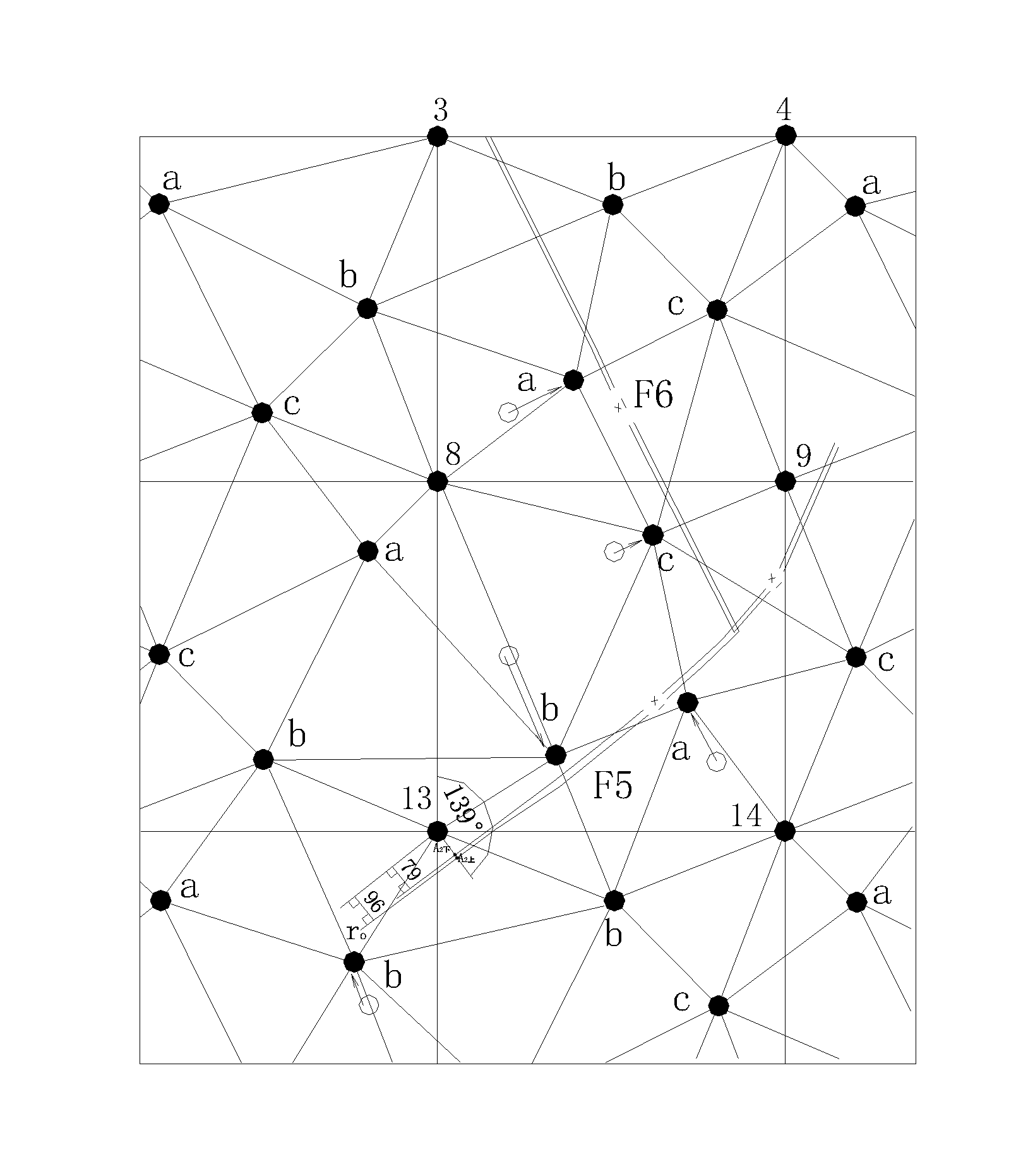
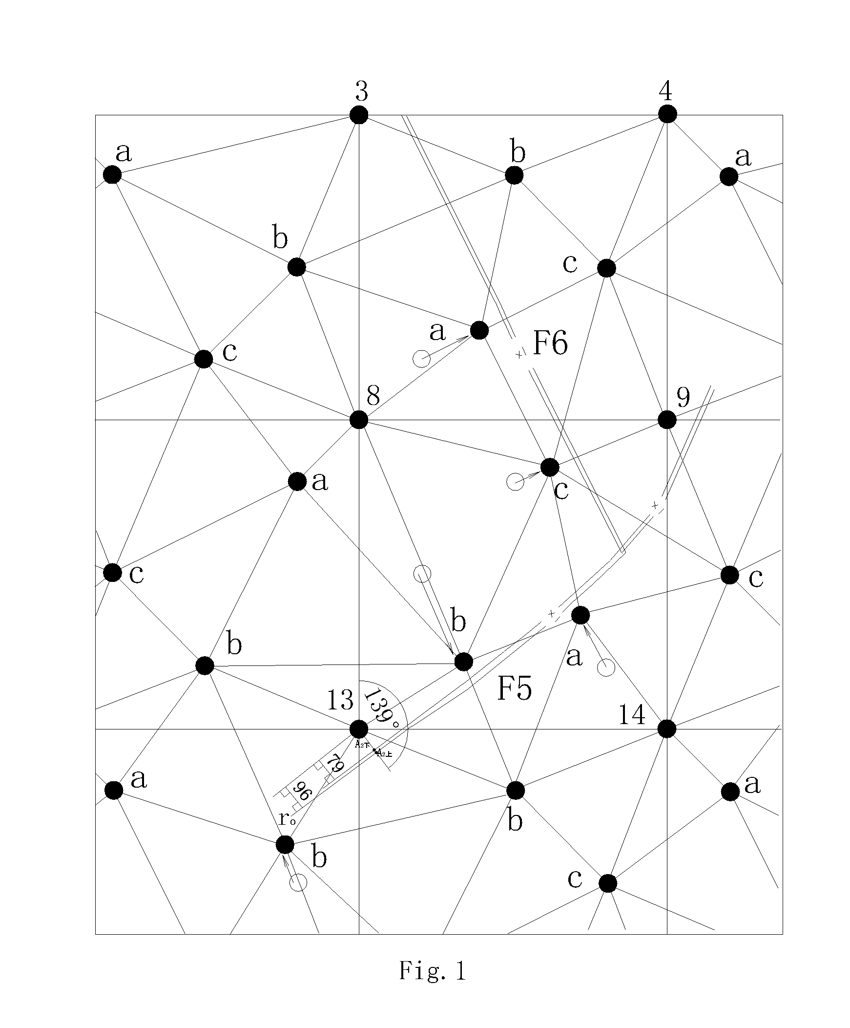
[0234]2 Shown in FIG. 1, (1) four sampling points are respectively arranged at four vertexes of basic square, the plane coordinates for the four vertexes respectively are (0, 0), (1000, 0), (1000, 1000) and (0, 1000); (2) three sampling points are dispersed within basic square, the plane coordinates of points a, b and c respectively are a(200, 200), b (500, 800), c (800, 500); (3) join the above three sampling points a, b and c by triangle; (4) select a vertex from the four vertexes of the basic square; the sum of distances from the selected vertex point to two adjacent samp...

example 2

Specific Examples 2

[0283]Shown in FIGS. 8 to 13, the difference between this example and example 1 is: in step 2, the three sampling points dispersed within the basis square are respectively, a (300, 300), b (400, 750), c(800, 400). Other steps are the same with example 1.

example 3

[0284]Shown in FIGS. 14 to 19, the difference between this example and example 1 is: in step 2, (1) arrange one sampling point at the midpoint of right side of the square, the total of sampling points are eight, shown in FIG. 14, the eight sampling points are respectively (0, 0), (1000, 0), (1000, 1000), (0, 1000), a (277, 454), b (500, 800), c (679, 200), d (1000, 500). (2) respectively join the sampling points from the midpoint of right side of the basic square to the two adjacent sampling points of triangle vertexes inside the square, (3) respectively join the sampling points from the two vertexes of basic square on the same straight line with the midpoint of right side of the basic square to a adjacent sampling point of triangle vertexes inside the square, (4) respectively join the sampling points from the other two vertexes of basic square to the two adjacent sampling points of triangle vertexes inside the square, at the same time, remove the longest joint line, among the four ...


PUM


Abstract

A set of geological exploration methods of using the non-section methods and rotary networks formed by triangulated irregulars. It aims to directly construct high-precision three-dimensional models, plans and sections for solving the drawbacks of existing geological exploration methods, such as the dispersion of drill holes, the faults tracking, the controlling of structures, minelayers/stratum/ore bodies, the bending correction of drill holes, and the geological map-making methods.

Description

[0001]Geological exploration methods of directly constructing high-precision three-dimensional models, plans and sections for geological exploration based on the non-section methods and the rotary-matching networks formed by triangulated irregularsBACKGROUND OF THE INVENTION[0002]1. Field of the Invention[0003]The invention relates generally to a set of geological exploration methods in geological exploration field, which is suitable for directly constructing high-precision geological exploration three-dimensional models, plans and sections.[0004]2. Description of the Prior Art[0005]The existing geological exploration methods, of using the square / rectangle / triangle / hexagon / radial networks, the correction methods for curved drill holes, the adjusting methods for the positions of drill holes according to the three adjacent drill holes which met the same fault, and the map-making methods of mapping plans after mapping sections, face a number of challenges, listed as follows:[0006]1) Th...

Claims


Application Information

Patent Timeline
IPC IPC(8): G01V9/00
CPCG01V9/00E21B49/00
Inventor HUANG, GUIZHI
Owner HUANG GUIZHI
Why Eureka
Try Eureka