
Map moving apparatus

a moving apparatus and map technology, applied in the direction of navigation instruments, traffic control systems, instruments, etc., can solve the problems of troublesome operation, difficult to grasp the entire image, and inability to provide user information regarding points, etc., to improve safety during travel, easy to find facilities or the like, and simple operation of users

Active Publication Date: 2007-04-12
ALPINE ELECTRONICS INC
View PDF8 Cites 26 Cited by
  • Summary
  • Abstract
  • Description
  • Claims
  • Application Information

AI Technical Summary

Benefits of technology

[0014] Therefore, it is a primary object of the present invention to perform a desired map movement by a simple input operation without continuously performing an operation for moving a map screen display region and to provide guidance information according to the movement of the map screen display region.
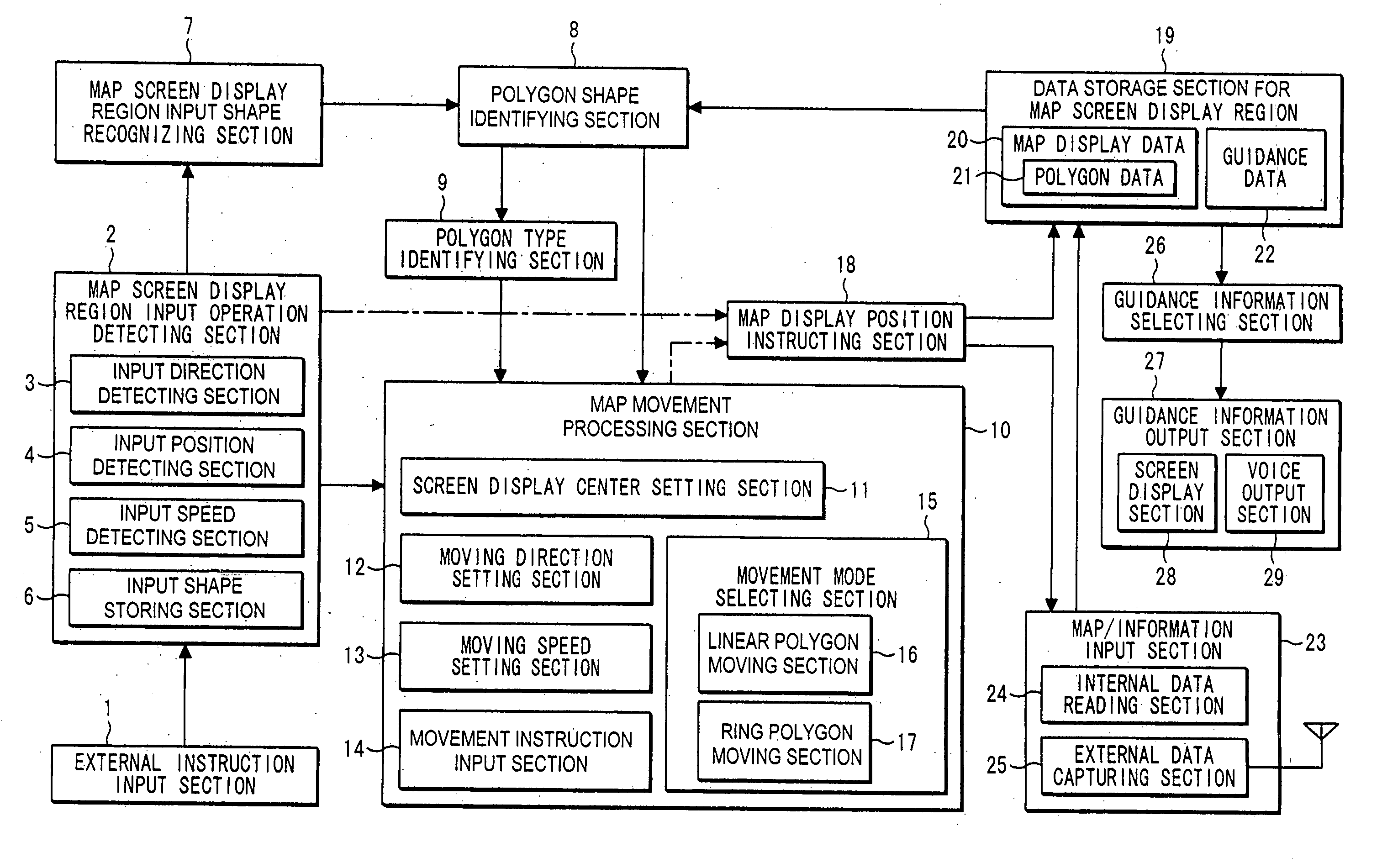
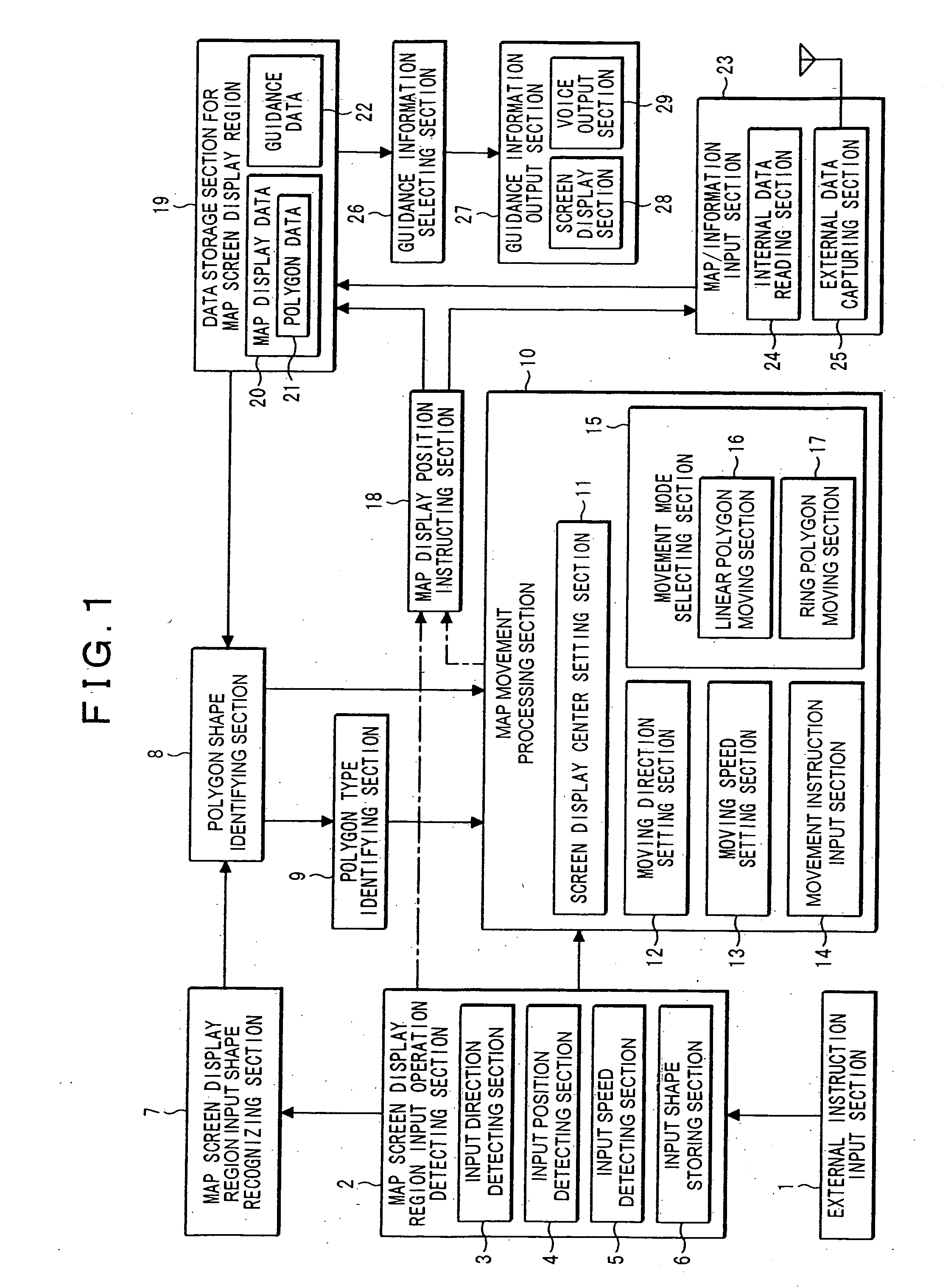
[0025] Further, another embodiment of a map moving apparatus according to the present invention includes moving speed setting means for decreasing the map moving speed when guidance information exists.
[0034] As described above, one aspect of the present invention is that the map screen display region moves along a selected polygon by a simple operation of the user, so that the user can easily find facilities or the like around the selected polygon from the map. Further, since the map screen display region moves along the selected polygon, the user can obtain detailed geographic information around the polygon and traffic information such as traffic congestion and traffic control without continuously operating the navigation apparatus. Moreover, the user can obtain information of a road or a coastline ahead, on which he / she is traveling without continuously operating the navigation apparatus, so that safety during traveling can be improved even when a driver operates the apparatus.
[0035] Furthermore, in the case where traffic congestion or traffic control occurs in a particular area, guidance can be performed by temporarily stopping the movement of the map or reducing the movement speed, so that the user can easily obtain information about an incident occurring in the area that the user wanted to refer to.

Problems solved by technology

The navigation apparatus is capable of displaying maps from a wide range to a narrow range in various scales by using the above-described map data, but it cannot display detailed information when displaying a wide range (small scale), and it becomes difficult to grasp the entire image, that is, a positional relationship with surrounding areas when displaying a narrow range (large scale) due to the characteristics of the map database and navigation apparatus, so that a user arbitrarily selects a scale considered to be most appropriate, to display a map on the map screen.
However, in this technique, since a map screen display region is moved along a route, it is impossible to provide the user with information regarding points that do not exist near the route.
When changing a display region of the map in the conventional navigation apparatus, the user specified a direction of moving the screen by using a touch panel function on the display screen or an input device such as a scroll key on a remote controller to move the screen away from a currently displayed screen region along the particular road, and searched for restaurants along the road or near the road, so that a problem arose that the operation became troublesome to the user.
Furthermore, in the case where the user will travel around a lake and wants to know the presence of a road closure that exists on the road around the lake or the positions of facilities such as shops and restaurants around the lake, if only a part of the lake is displayed on the current display screen, the user searches the road closure, shops and restaurants around the lake on the map while moving the map screen display region along the lake by the above-described manual operation, so that a problem existed of reducing safety during traveling.
When the user wanted to obtain information around a certain target such as a road, river or coast, for example, the user continuously operated the navigation apparatus until the required information was obtained, and this caused a problem of not only applying a burden to the user but also interrupting safe driving when the user is driving a car.
In addition to the map screen display device such as the navigation apparatus, the same burden applies to the case of displaying a map on a personal computer and moving the screen display region of the map, for example.

Method used


Image

  • Map moving apparatus
  • Map moving apparatus
  • Map moving apparatus

Examples


embodiment 1

[0045] A description will first be made for a map moving method according to the present invention based on a specific example. FIG. 4 shows an example of the operation of the present invention. Rectangular shapes represent map display regions on a screen. Reference numerals (1) and (2) represent shapes that the user inputs, and P1 and P2 show polygons selected by the present invention based on the shapes (1), (2) that the user inputs.

[0046] A polygon comprises positional information of a polygonal shape formed by connecting a plurality of points expressed by coordinate values such as longitude and latitude, and it is the same as polygonal shape data that is generally used to display boundaries or the like of administrative districts on a map. A polygon is used to display a region showing land formations such as a mountain, river, lake, desert and reservoir, buildings such as a shopping mall, an airport and a school, and their regions, in map data for navigation use, and it has bee...


PUM


Abstract

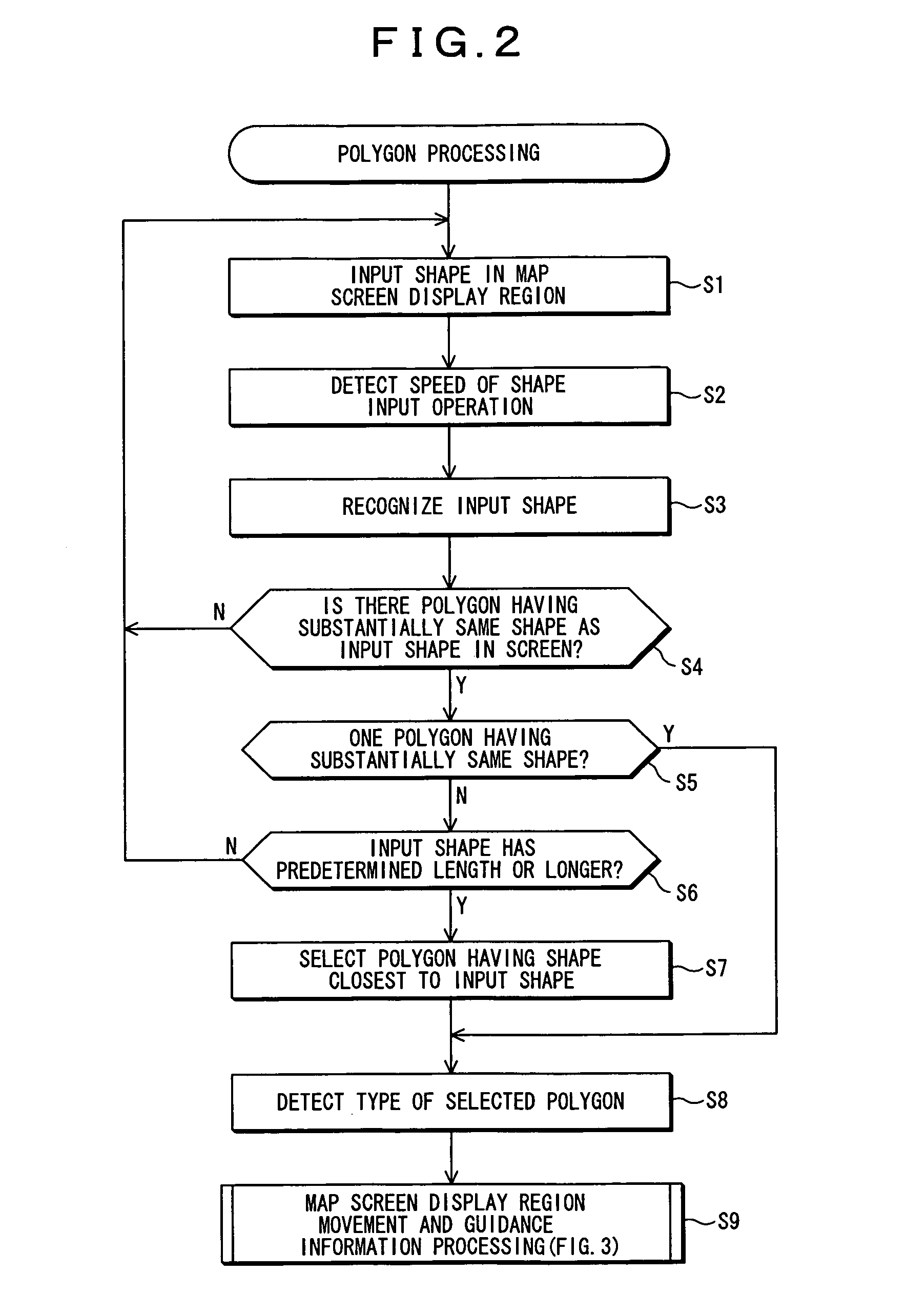
A map moving apparatus capable of performing desired map movement by a simple input operation without requiring a continuous operation by a user in moving a map screen display region is disclosed. An operated direction, an operated position, an operated speed and the like are detected from an input operation that a user performs on the map screen display region, and a map screen display region input shape recognizing section recognizes an input shape. A polygon shape identifying section extracts data having substantially the same shape as the recognized input shape from polygon data in map display data by using a matching method. When data having substantially the same shape exists, a type of the polygon is identified. In a movement mode selecting section, the movement of a screen map reverses direction when it reaches an end portion in the case where the polygon type is a linear shape, and the movement circulates to continue movement of the map screen where the type is a ring shape with no end portion. In the case where guidance information is detected during the movement of the map, guidance is provided on a screen or by voice.

Description

RELATED APPLICATIONS [0001] The present application claims priority to Japanese Patent Application Number 2005-297043, filed Oct. 11, 2005, the entirety of which is hereby incorporated by reference. BACKGROUND OF THE INVENTION [0002] 1. Field of the Invention [0003] The present invention relates to a map moving apparatus capable of automatically moving a map screen display region along a particular display polygon by using a simple operation of a user. [0004] 2. Description of the Related Art [0005] In recent years, installing a navigation apparatus in a vehicle has become widely known. A regular navigation apparatus to be installed in a vehicle or the like includes a map / information storage medium such as a CD-ROM, a DVD-ROM or a hard disk, which stores map data for drawing a map and facility data for searching a facility or the like; a data retrieval device that retrieves the data from the map / information storage medium; a monitor that displays a map or the like; and a vehicle pos...

Claims


Application Information

Patent Timeline
Patent Type & Authority Applications(United States)
IPC IPC(8): G01C21/32
CPCG01C21/367G06F3/0485G06F3/04883
Inventor BABA, AKIHISAKAWAHATA, MITSURU
Owner ALPINE ELECTRONICS INC
Learn More