
System and methods for IP and VoIP device location determination

a technology of system and method, applied in the field of system and method for determining the position of ip and voip devices, can solve the problems of no single current provider has a network plant, and no current provider can intelligently geo-reference to either network

Active Publication Date: 2007-02-08
IPOSI
View PDF28 Cites 221 Cited by
  • Summary
  • Abstract
  • Description
  • Claims
  • Application Information

AI Technical Summary

Benefits of technology

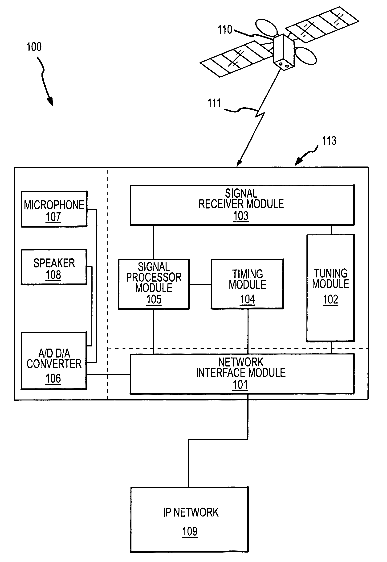
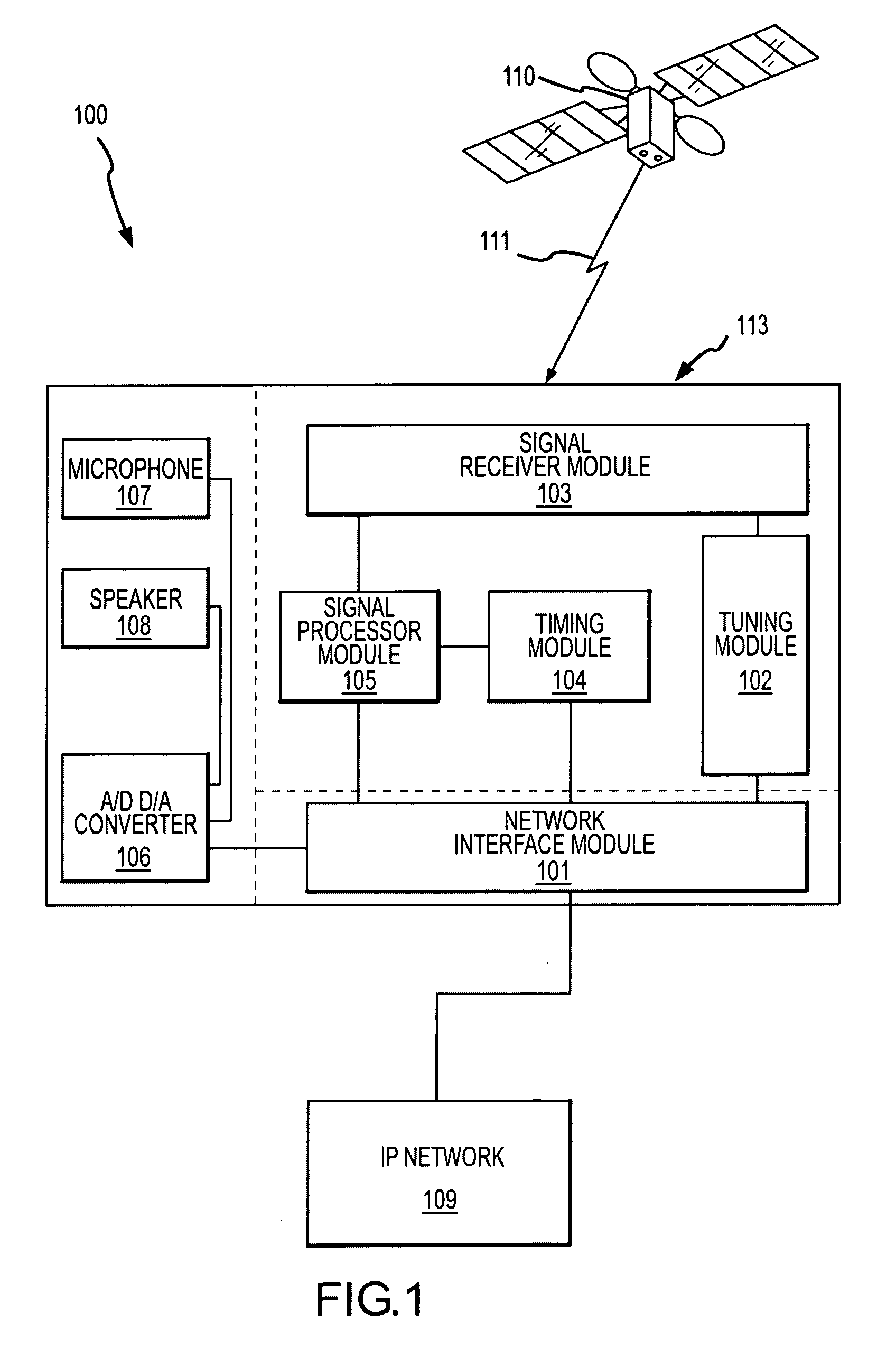
[0006] The present invention relates to systems for determining positions of network-attached devices and associated methodologies. In particular, an automated position determination system is provided, which when added inside host equipment operates over standards-based broadband communication networks, that is, it uses those networks in unmodified form. One aspect is that the systems may function over asynchronous networks, including delivery of precise time and frequency via packet signaling which provides the foundation for acquiring weak GNSS signals virtually anywhere, automatically and inexpensively.
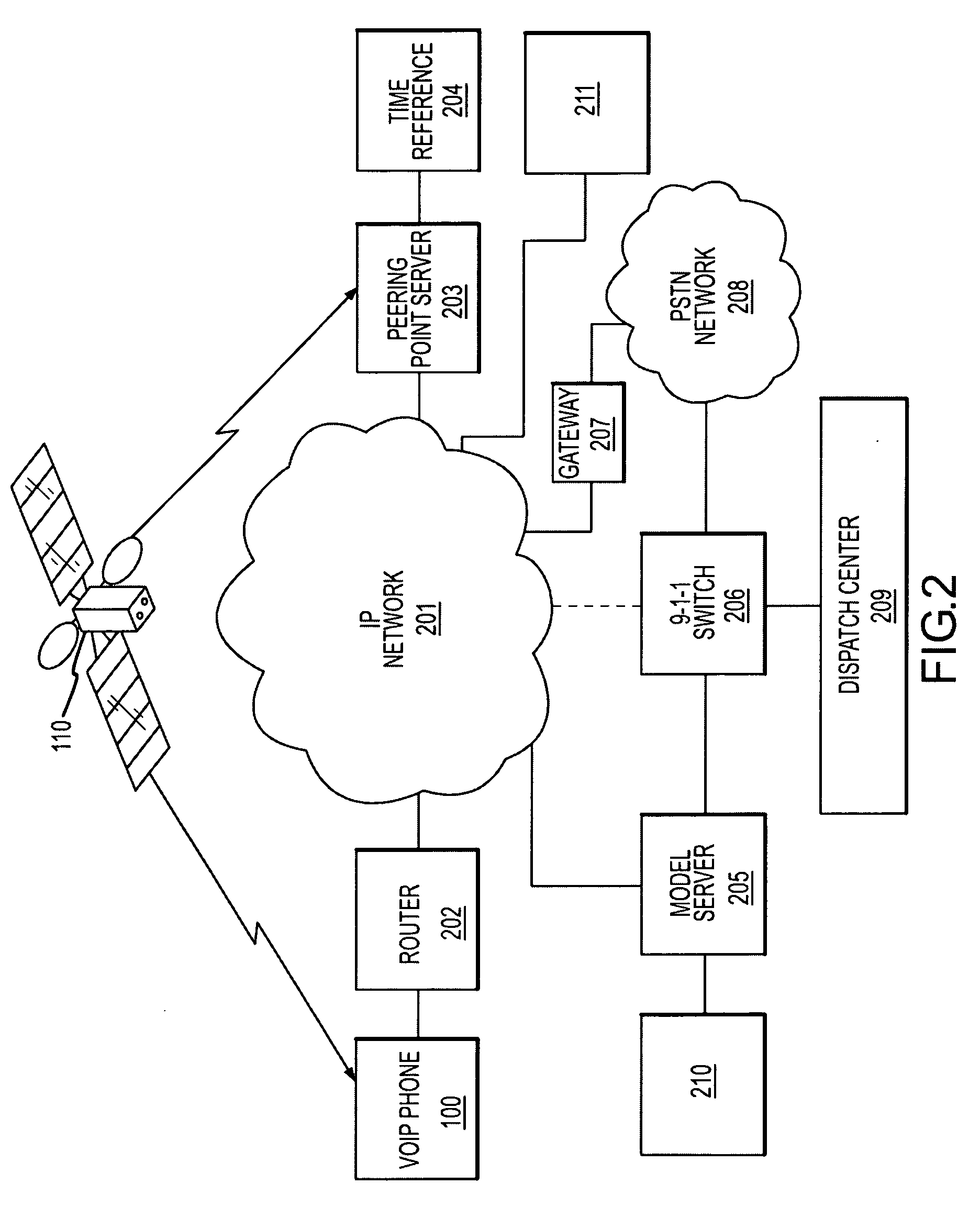
[0007] One embodiment of the present invention provides a method to precisely position network-connected devices using a specific configuration of specialized servers, which in turn serve a multitude of inexpensive, standardized, position determination edge devices with embedded receivers. These receivers readily embed as silicon components or are fully die-level integrated into a diverse array of commercially available VoIP and IP devices. Consistent with the service feature of VoIP, these devices may be readily moved, and may operate as “nomadic” changing between portable and fixed usage behavior. It is therefore desirable to seamlessly maintain an updated location should consumers move the device to different places. These devices generally attach to networks that do not have a common, precise time and / or frequency reference. When called for by control logic and in response to a programmed set of conditions, each remote receiver may provide and transfer network messages using conventional IP connection and / or packet protocols. Furthermore, these devices interact using conventional streaming packets that provide valuable signals to disseminate time and frequency, which enable remote receivers to align local frequency and time and then capture positioning system signals such as target navigation satellite signals. These signals provide range measurements. The signals are then encoded and sent back to a central server, and once satisfying certain accuracy criteria, are then transferred into an industry standard Location Information Server (LIS) database as part of modem VoIP and IP device location management standards or government regulatory mandates.
[0008] Aspects of the present invention provide for extended receiver sensitivity, relative to known commercial GPS systems, in order to acquire weak in-building GNSS signals. Additional aspects are operable to extend the coherent signal integration time, relative to known commercial GPS systems, when signal conditions warrant though acquisition and measurement of single GNSS signal acquisitions events which are later clock-corrected to form a position assembled from time-spread observations. Still further aspects use knowledge of common router connections to combine nearby receiver measurements leading to improved building address position accuracy.

Problems solved by technology

However, current IP networks are not geo-referenced to either intelligently route or pinpoint the location of E911 callers.
VoIP service providers are also no longer 100% facilities based providers.
Additionally, no single current provider has a network plant with a reach of VoIP service that covers all the geographical points at which VoIP subscribers connect.
This method may have limited effectiveness, would require service suspension if the user connects at a new location, and would incur additional mapping costs when the user connects at a new location.
A common belief or premise of these proposals is GPS cannot operate successfully to reach receiver points located inside buildings and homes due to limits of effective satellite signal sensitivity.
This limitation is often attributed to the fact that the satellites are far away and have comparatively limited transmission power.

Method used


Image

  • System and methods for IP and VoIP device location determination
  • System and methods for IP and VoIP device location determination
  • System and methods for IP and VoIP device location determination

Examples


Embodiment Construction

[0047] In the following description, the invention is generally set forth in the context of a Voice Over Internet Protocol (VoIP) device attached an Internet Protocol (IP) network receiving signals from the Global Positioning System operated by the U.S. military (GPS). Indeed, the invention has a number of benefits and provides useful results in this regard. However, it will be appreciated that various aspects of the present invention are not limited to VoIP devices, IP network applications or systems receiving signals from the GPS. Accordingly, the following description should be understood as exemplary of the invention and not by way of limitation.

[0048] The determination of the location of a device connected to a computer network is useful in many regards. To achieve this determination, a device is provided herein that is capable of receiving signals from a positioning system and interfacing with a computer network. Aspects of a device having such capabilities will be described ...


PUM


Abstract

A method and system for precise position determination of general Internet Protocol (IP) network-connected devices. A method enables use of remote intelligence located at strategic network points to distribute relevant assistance data to IP devices with embedded receivers. Assistance is tailored to provide physical timing, frequency and real time signal status data using general broad band communication protocols. Relevant assistance data enables several complementary forms of signal processing gain critical to acquire and measure weakened or distorted in-building Global Navigation Satellite Services (GNSS) signals and to ultimately extract corresponding pseudo-range time components. A method to assemble sets of GNSS measurements that are observed over long periods of time while using standard satellite navigation methods, and once compiled, convert using standard methods each pseudo-range into usable path distances used to calculate a precise geographic position to a known degree of accuracy.

Description

RELATED APPLICATIONS [0001] This application claims priority from U.S. Provisional Patent Application No. 60 / 680,190, filed May 12, 2005, entitled “iPosi Receiver for Deep In-Building Signal Acquisition and GPS Pseudorange Capture,” the entire disclosure of which is incorporated by reference herein.FIELD OF THE INVENTION [0002] The present invention relates to systems for determining positions of network-attached devices in general and, in particular, for determining positions of devices connected to asynchronous networks and capable of receiving signals from Global Navigation Satellite Services (GNSS). The invention has particular application for determining positions of Voice Over Internet Protocol (VoIP) devices connected to the Internet and capable of receiving signals from the Global Positioning System (GPS). BACKGROUND OF THE INVENTION [0003] Global satellite navigation fulfills pervasive needs. Initially a service for military and general aviation, Global Navigation Satellite...

Claims


Application Information

Patent Timeline
IPC IPC(8): H04L12/66G01S19/35G01S19/13G01S19/49
CPCH04M2242/04H04M3/42102H04M7/006H04M3/42365G01S19/252G01S19/06H04M2242/30G01S5/0027G01S19/235G01S19/25G01S19/42H04M3/42348G01S19/17G01S19/05H04W64/00
Inventor LEE, RICHARD M.KEEGAN, RICHARD
Owner IPOSI
Learn More