
Display method and apparatus for navigation system

a navigation system and display method technology, applied in frequency-division multiplex, navigation instruments, instruments, etc., can solve the problems of large additional data size and shorter zooming time than the conventional zooming method, and achieve fast zooming of map images, high speed, and the effect of providing a user with a zoomed imag

Inactive Publication Date: 2005-03-03
ALPINE ELECTRONICS INC
View PDF13 Cites 67 Cited by
  • Summary
  • Abstract
  • Description
  • Claims
  • Application Information

AI Technical Summary

Benefits of technology

[0011] It is, therefore, an object of the present invention to provide a display method and apparatus for navigation system which is capable of zooming the map image at high speed without need to access the map data each time.
[0013] It is a further object of the present invention to provide a display method and apparatus for navigation system which is capable of easily changing the map scale and finding a destination on the screen.
[0014] The display method and apparatus of the present invention eliminates need of repeating an initial data preparation step to retrieve map data from a map data storage. Thus, the initial data displayed on a screen are stored in a memory, and the stored data are used for the next zoom operation. When zooming-in the map image, the display method uses only the stored data in the memory to display. When zooming-out the map image, the display method may need additional data in the map data storage. However, the size of the additional data is small because the additional data are used only for filling in a surrounding area, not for the whole screen, thus, a zooming time is much shorter than that required in the conventional zooming method.
[0019] Another aspect of the present invention is a display apparatus for quickly zooming the map image on the navigation system. The display apparatus is constituted by various means for achieving the display method described above in which the radial scaling method is conducted.
[0020] According to the present invention, the display method and apparatus is able to provide a user a zoomed image very quickly by using the radial scaling method. In the radial scaling method, the map image is either enlarged or shrunk relative to the center of the display screen. In the present invention, it is unnecessary to access the memory and retrieve new map data each time when the zooming operation is conducted. Thus, the zooming operation is conducted at high speed. Even when additional map data has to be acquired, such as when zooming-out the map image, the amount of new data required is much smaller than that required in the conventional technology, thereby achieving the zooming operation at high speed.

Problems solved by technology

However, the size of the additional data is small because the additional data are used only for filling in a surrounding area, not for the whole screen, thus, a zooming time is much shorter than that required in the conventional zooming method.

Method used


Image

  • Display method and apparatus for navigation system
  • Display method and apparatus for navigation system
  • Display method and apparatus for navigation system

Examples


Embodiment Construction

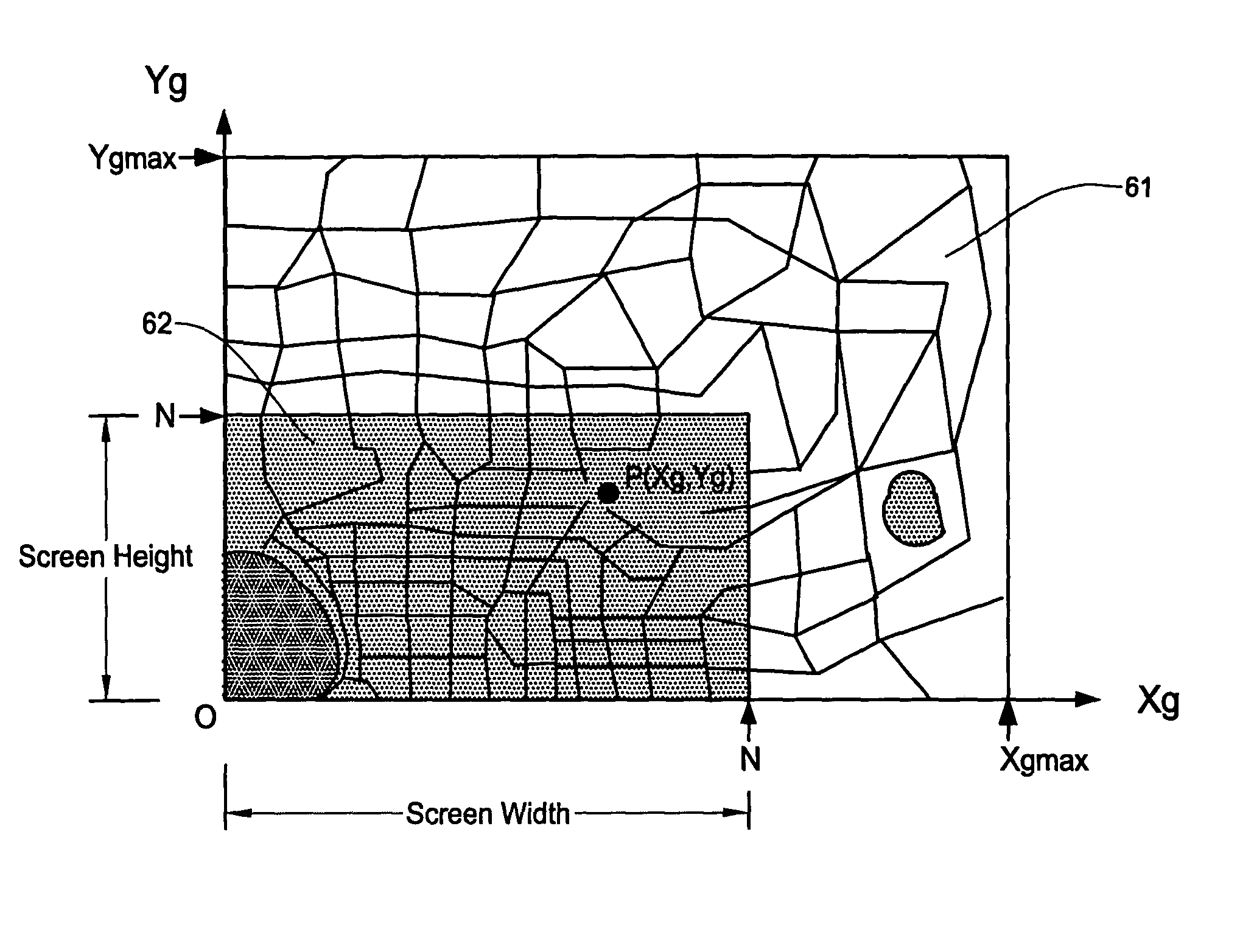
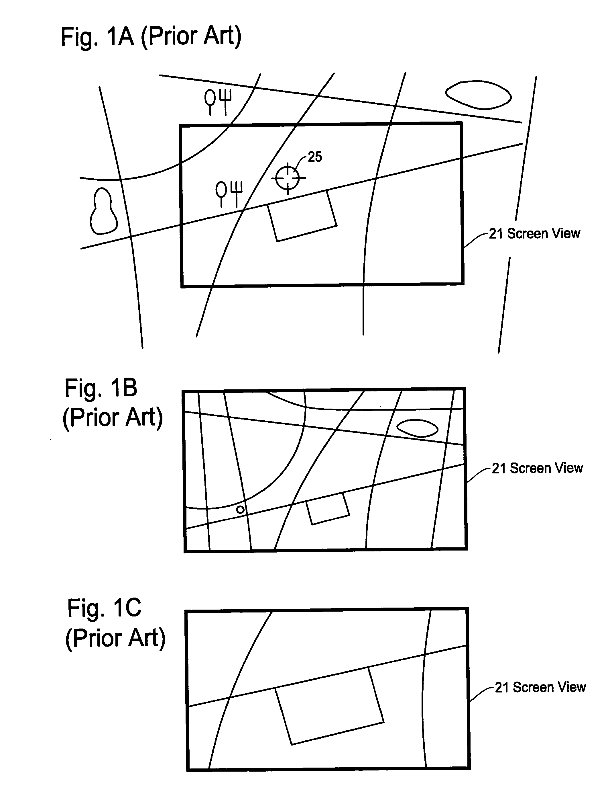
[0034] The present invention will be described in detail with reference to the accompanying drawings. The navigation system of the present invention is designed to enable a user to quickly observe the zoomed views which provide broad or detailed views of the map information. The zooming operation is conducted with respect to a center of the display screen so that the map data in the map memory is fully utilized during the zooming operation without requiring every time to access to a map data storage such as a DVD.

[0035]FIG. 3 shows a block diagram of the navigation system in the present invention. While the vehicle navigation system is explained for an illustration purpose, the present invention can also be applied to other types of navigation system such as a portable navigation device implemented by a PDA (personal digital assistant) device or other hand-held devices.

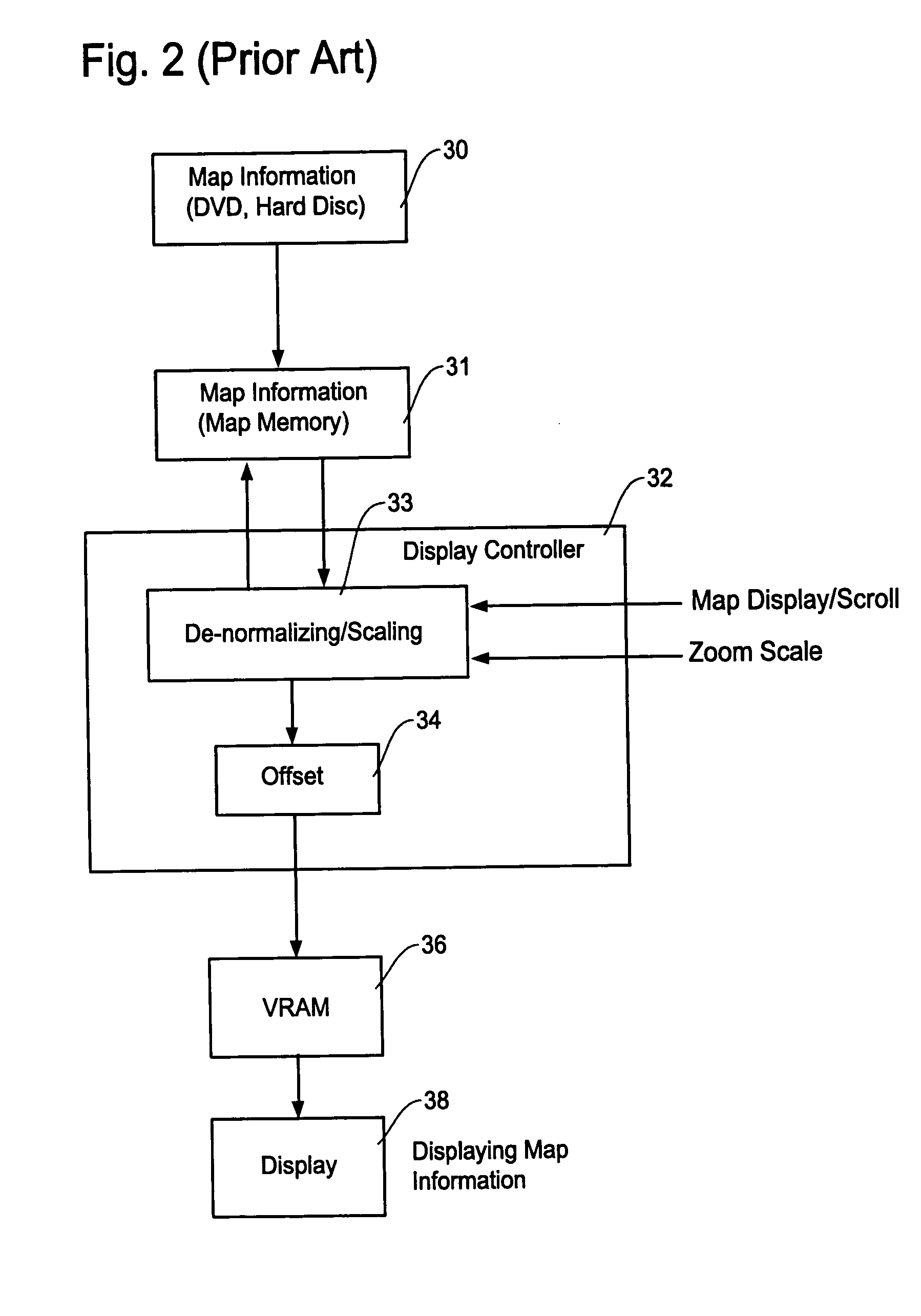
[0036] The navigation system includes a map storage medium 41 such as a CD-ROM, DVD, hard disc or other storage m...


PUM


Abstract

A display method and apparatus for navigation system enables a user to quickly view zoomed images by using a radial scaling method. The display method includes the steps of: reading out map data from a map data storage for displaying a map image on a screen of a navigation system; converting the map data to screen coordinates so that an intended map image is displayed on a correct position on the screen; zooming the map image by enlarging or shrinking distances of points on the map image relative to a center of the screen; and storing the map data converted to the screen coordinates in a memory for use with a further operation of changing the map scale.

Description

FIELD OF THE INVENTION [0001] This invention relates to a display method and apparatus for navigation system, and more particularly, to a display method and apparatus which is capable of easily and quickly zooming a map image on a display screen of the navigation system by radially scaling the map image relative to a center of the display screen. BACKGROUND OF THE INVENTION [0002] A navigation system performs travel guidance for enabling a user to easily and quickly reach the selected destination. A typical example is a vehicle navigation system where a navigation system is equipped in a vehicle to assist a user (driver) to smoothly travel to the destination. Such a navigation system detects the position of the user or user's vehicle, reads out map data pertaining to an area at the current vehicle position from a data storage medium, for example, a CD-ROM (compact disc read-only memory), a DVD (digital versatile disc), or a hard disc. Alternatively, such map data can be provided to ...

Claims


Application Information

Patent Timeline
IPC IPC(8): G01C21/34G01C21/36G01S1/00G01S19/48G08G1/123G09B29/10H04Q7/00
CPCG09B29/106G01C21/36
Inventor HAN, MAUNG W.
Owner ALPINE ELECTRONICS INC
Learn More