Route-free navigation algorithm and system applying satellite positioning
A technology for route navigation and application of satellites, applied in the field of satellite navigation, can solve problems such as lack of navigation capabilities, and achieve the effect of saving later maintenance and upgrade costs
- Summary
- Abstract
- Description
- Claims
- Application Information
AI Technical Summary
Problems solved by technology
Method used
Image


Examples
Embodiment 1
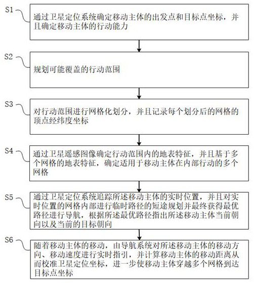
[0045] as attached figure 1 As shown, a pathless navigation algorithm using satellite positioning, the navigation algorithm includes the following steps:
[0046] S1: Determine the coordinates of the starting point and target point of the moving subject through the satellite positioning system, and determine the action ability of the moving subject;
[0047] S2: Plan the scope of action that may be covered;
[0048] S3: Perform grid division on the action range, and record the latitude and longitude coordinates of the vertices of each divided grid;
[0049] S4: Determine the surface features within the action range through satellite remote sensing images, and determine multiple grids suitable for the moving subject within the action range based on the surface features of the multiple grids;
[0050] S5: Track the real-time position of the moving subject through a satellite positioning system, and perform short-distance planning of a temporary path inside the grid of the real...
Embodiment 2
[0093] This embodiment should be understood as including at least all the features of any one of the foregoing embodiments, and further improved on the basis thereof;
[0094] Further, satellite remote sensing images have certain defects, such as insufficient resolution, general classification accuracy of surface features by spectral characteristics, etc. Therefore, in this embodiment, the ground information acquisition module provided on the moving subject is included to analyze the surface features. data for further collection and analysis;
[0095] In one embodiment, the ground information acquisition module includes a scanning device configured with a laser radar, and further judges and analyzes the environment around the moving subject, including combining and analyzing the data of the ground information acquisition module and the satellite information acquisition module;
[0096] as attached Figure 5 As shown in the figure, in order to use the lidar scanning device, af...
Embodiment 3
[0103] This embodiment should be understood as including at least all the features of any one of the foregoing embodiments, and further improved on the basis thereof;
[0104] In order to further analyze and obtain more accurate surface features, the ground information acquisition module includes using an RGB image sensor to obtain current ground information, and establishes a surface feature analysis model through a deep learning method, so that the surface feature analysis model can be combined with satellite remote sensing. Map image data to achieve more accurate classification of surface features;
[0105] Among them, the preliminary classification of surface features can be divided into seven categories, including: grass, soil, rock, ice, shallow water, asphalt roads, large obstacles, and includes mixed types in the seven categories;
[0106] Further, it includes further subdivision of the above seven types of land types, such as green grassland, dry grassland, loose sand...
PUM
 Abstract
Description
Claims
Application Information
 - R&D
- Intellectual Property
- Life Sciences
- Materials
- Tech Scout
- Unparalleled Data Quality
- Higher Quality Content
- 60% Fewer Hallucinations
Browse by: Latest US Patents, China's latest patents, Technical Efficacy Thesaurus, Application Domain, Technology Topic, Popular Technical Reports.
© 2025 PatSnap. All rights reserved.Legal|Privacy policy|Modern Slavery Act Transparency Statement|Sitemap|About US| Contact US: help@patsnap.com