Unmanned multi-laser radar collaborative simulation method based on GPU acceleration

A co-simulation and unmanned driving technology, applied in the direction of constraint-based CAD, design optimization/simulation, instruments, etc., can solve the problems of low efficiency of lidar simulation and lidar co-simulation, and achieve efficient utilization and high-efficiency simulation. Effect

Pending Publication Date: 2022-05-20
TONGJI UNIV
View PDF0 Cites 3 Cited by
  • Summary
  • Abstract
  • Description
  • Claims
  • Application Information

AI Technical Summary

Problems solved by technology

[0003] However, the current unmanned driving simulation software is inefficient in the simulation of lidar. For example, well-known simulation platforms such as CARLA use a CPU-based method for lidar to calculate the intersection of laser and object to generate point clouds. The low efficiency is far from meeting the simulation needs. Even if the simulation platform SVLSimulator developed by LGSiliconValleyLab adopts the method of GPU acceleration, it is difficult to efficiently co-simulate multiple lidars under resource constraints.

Method used


Image

  • Unmanned multi-laser radar collaborative simulation method based on GPU acceleration
  • Unmanned multi-laser radar collaborative simulation method based on GPU acceleration
  • Unmanned multi-laser radar collaborative simulation method based on GPU acceleration

Examples


Embodiment Construction

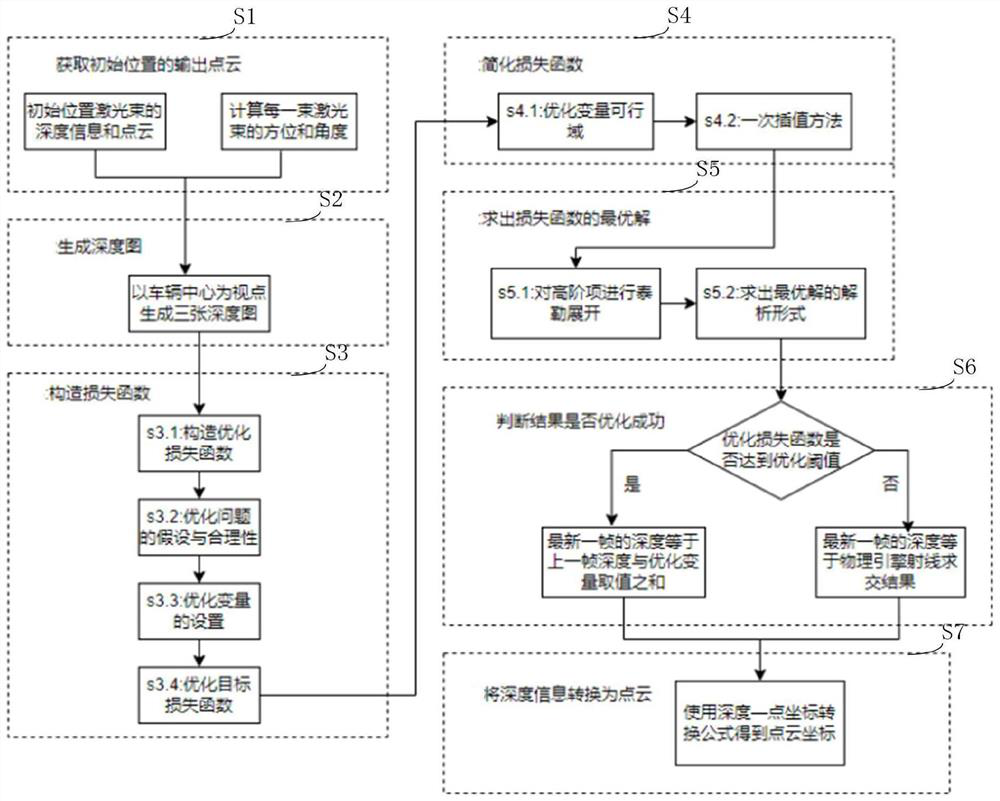
[0022] In order to make the technical means, creative features, goals and effects of the present invention easy to understand, the following embodiments will specifically illustrate a GPU-accelerated multi-lidar co-simulation method of the present invention in conjunction with the accompanying drawings.

[0023] In this embodiment, a multi-lidar co-simulation method based on GPU acceleration is provided.

[0024] First, the coordinate system used in this embodiment is described: this embodiment adopts a left-handed coordinate system for symbolic representation, the X-axis represents the front-to-back direction and the positive direction is forward, the Y-axis represents the left-right direction and the positive direction is rightward, and the Z-axis Represents the up and down direction and the positive direction is down. And use Euler angles (pitch, yaw, roll) to represent the direction of the vector. The pitch angle pitch represents the angle in the vertical direction, that ...


PUM


Abstract

The invention discloses an unmanned multi-laser radar collaborative simulation method based on GPU acceleration, and the method is characterized in that the method comprises the following steps: 1, obtaining the depth information of laser radars at the initial position of a vehicle, converting the depth information into point cloud output corresponding to the laser radars, and obtaining the depth information and point cloud of the laser radars at the initial position; step 2, based on the latest position of the vehicle, using a GPU to generate a depth map surrounding the vehicle; step 3, constructing an optimization loss function and an optimization problem based on the depth map; step 4, simplifying and optimizing a loss function; 5, solving the optimal solution of the optimization problem; 6, judging whether the optimization loss function reaches an optimization threshold value or not according to the optimal solution; and 7, converting the depth information of the laser radar into a corresponding point cloud.

Description

technical field [0001] The invention relates to the field of unmanned driving, in particular to a GPU-accelerated multi-lidar collaborative simulation method for unmanned driving. Background technique [0002] Since lidar is widely used in unmanned driving and used to generate point clouds, its simulation has also received more attention and challenges. Multi-line lidar needs to emit a large number of laser beams at high frequency, so the simulation requires real-time and high-performance calculations, especially in real simulation requirements, it is often necessary to carry out co-simulation on a single vehicle equipped with multiple lidars, which further increases the requirements for computing resources. Big. [0003] However, the current unmanned driving simulation software is inefficient in the simulation of lidar. For example, well-known simulation platforms such as CARLA use a CPU-based method for lidar to calculate the intersection of laser and object to generate p...

Claims


Application Information

Patent Timeline
Patent Type & Authority Applications(China)
IPC IPC(8): G06F30/20G06F17/11G06T3/40G06F111/04
CPCG06F30/20G06F17/11G06T3/4007G06F2111/04Y02T10/40
Inventor 赵君峤毕晓栋叶晨杜嘉文王胜坤
Owner TONGJI UNIV
Why Eureka
Try Eureka