Remote sensing image processing method and system for land resource management

A technology of remote sensing image and processing method, which is applied in the field of image processing to achieve the effects of improving classification accuracy, reducing misclassification and omission, and reducing the amount of calculation.

Active Publication Date: 2022-05-06
山东沃能安全技术服务有限公司
View PDF7 Cites 0 Cited by
  • Summary
  • Abstract
  • Description
  • Claims
  • Application Information

AI Technical Summary

Problems solved by technology

[0006] The invention provides a remote sensing image processing method and system for land resource management to solve existing problems

Method used


Image

  • Remote sensing image processing method and system for land resource management
  • Remote sensing image processing method and system for land resource management
  • Remote sensing image processing method and system for land resource management

Examples


Embodiment Construction

[0060] The following will clearly and completely describe the technical solutions in the embodiments of the present invention with reference to the accompanying drawings in the embodiments of the present invention. Obviously, the described embodiments are only some, not all, embodiments of the present invention. Based on the embodiments of the present invention, all other embodiments obtained by persons of ordinary skill in the art without making creative efforts belong to the protection scope of the present invention.

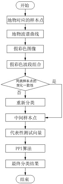
[0061] An embodiment of a remote sensing image processing method used for land resource management of the present invention, such as figure 1 As shown, the method includes:

[0062] S1. Before classifying the ground features, the researchers first determine the ground features that need to be classified, that is, which categories the ground features on the remote sensing images need to be divided into, and then mark the corresponding ground features on the ima...


PUM


Abstract

The invention relates to the technical field of image processing, in particular to a remote sensing image processing method and system for land resource management, and the method comprises the steps: marking ground features on a remote sensing image, and determining sample points of initial sample classification of the ground features; acquiring a ground feature spectrum curve corresponding to the ground feature, and performing false color synthesis on wave bands corresponding to a wave crest point, a wave trough point and a maximum curvature point in the ground feature spectrum curve to obtain a false color image; obtaining a false color wave band combination, corresponding to each wave band of the false color image, in the RGB channel, and according to the change consistency of sample points of the same kind in different false color wave band combinations, performing reclassification on the sample points to obtain intermediate sample points; determining representative test vectors according to the intermediate sample points; and taking the representative test vector as a parameter of a PPI algorithm to determine a final sample point, and performing final sample classification on the remote sensing image according to the final sample point to obtain a classification result, so that the method improves the classification precision, and reduces the occurrence of wrong classification and missing classification.

Description

technical field [0001] The invention relates to the technical field of image processing, in particular to a remote sensing image processing method and system for land resource management. Background technique [0002] The management of land resources generally collects remote sensing images through satellites, and reflects land coverage and utilization, environmental monitoring, agricultural production estimation, and forest fires based on remote sensing images. Therefore, the identification of land types in remote sensing images is an essential part. Only Only by accurately classifying land types can the corresponding land resources be managed accurately from remote sensing images. [0003] With the development of computer technology, the method of artificial visual recognition of ground features has been gradually eliminated. Today's methods of ground feature recognition often use the method of supervised classification, that is, first select samples of different types of ...

Claims


Application Information

Patent Timeline
Patent Type & Authority Applications(China)
IPC IPC(8): G06V20/10G06V10/56G06V10/74G06V10/77
CPCG06F18/22G06F18/2135
Inventor 郝彦
Owner 山东沃能安全技术服务有限公司
Why Eureka
Try Eureka