A Spaceborne GNSS-R High-Precision Soil Moisture Estimation Method Based on Cygnss Data

A soil moisture and high-precision technology, which is applied in water resources assessment, material analysis, soil material testing, etc., can solve the problems that the accuracy of soil moisture estimation needs to be further improved, and has not been corrected by the system, so as to optimize the estimation model and improve the estimation accuracy Effect

Active Publication Date: 2022-05-31
INST OF GEOGRAPHICAL SCI & NATURAL RESOURCE RES CAS +1
View PDF0 Cites 0 Cited by
  • Summary
  • Abstract
  • Description
  • Claims
  • Application Information

AI Technical Summary

Problems solved by technology

However, the currently publicly released CYGNSS soil moisture products have not been systematically corrected, and have not been corrected for surface roughness and vegetation, and the accuracy of soil moisture estimation needs to be further improved

Method used


Image

  • A Spaceborne GNSS-R High-Precision Soil Moisture Estimation Method Based on Cygnss Data
  • A Spaceborne GNSS-R High-Precision Soil Moisture Estimation Method Based on Cygnss Data
  • A Spaceborne GNSS-R High-Precision Soil Moisture Estimation Method Based on Cygnss Data

Examples


Embodiment Construction

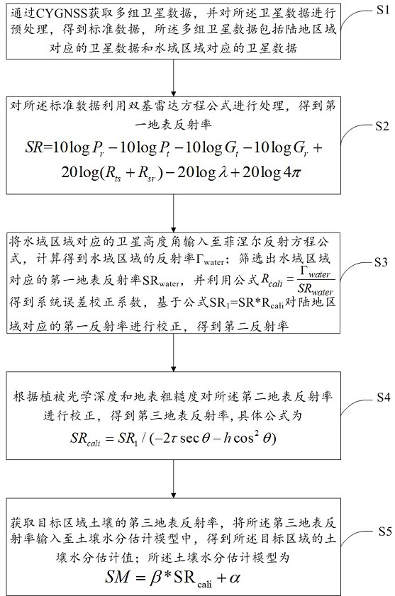
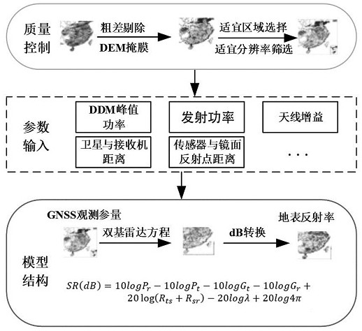
[0039] S2: the standard data is processed using the bistatic radar equation formula to obtain the first surface reflectivity.

[0041]

[0045]

[0046] Wherein, Ɛ represents the dielectric constant of pure water, and its value is 80, and E is the satellite elevation angle.

[0052]

[0055] In-depth analysis of the reflection signal generation mechanism to obtain the surface reflectance ratio corrected by vegetation and surface roughness [0055]

[0056]

[0058] Here, since the surface roughness of SMAP is on the microscopic scale, while the roughness of CYGNSS is on the macroscopic scale, previous studies

[0059] SMAP data download address ( ). Should

[0061] SM=β*SR

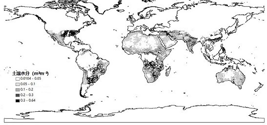
[0066] As shown in Figure 3, based on the method of the present invention, a schematic diagram of soil moisture is obtained after correction on January 1, 2019.


PUM


Abstract

The invention relates to a space-borne GNSS-R high-precision soil moisture estimation method based on CYGNSS data. Multiple groups of satellite data are obtained through CYGNSS, and the data are preprocessed to obtain standard data; the standard data is processed by bistatic radar equation to obtain the first Surface reflectivity; input the satellite elevation angle corresponding to the water area into the Fresnel reflection equation to calculate the reflectivity Γ water ; Filter out the first surface reflectance SR of the water area water , use the formula to get the system error correction coefficient, based on the formula SR 1 =SR*R cali Correct the first reflectance of the land area to obtain the second reflectance; correct the second surface reflectance according to the vegetation optical depth and surface roughness to obtain the third surface reflectance; obtain the third surface reflectance of the soil in the target area, input Go to the soil moisture estimation model to obtain the estimated soil moisture value of the target area; the present invention provides a method of correcting system errors, surface roughness and vegetation through CYGNSS data, and improves the accuracy of soil moisture estimation.

Description

A high-precision soil moisture estimation method for spaceborne GNSS‑R based on CYGNSS data technical field [0001] The present invention relates to the technical field of hydrological remote sensing. Specifically, it relates to a spaceborne GNSS‑based CYGNSS data R High-precision soil moisture estimation method. Background technique [0002] Soil moisture is an important component of hydrological processes, surface evapotranspiration, water migration, and carbon cycling. Tool Remote sensing of soil moisture products with high accuracy and high spatial and temporal resolution is an essential input for such applications. Global Soil Moisture Inversion It has always been a research topic in the field of optical remote sensing and microwave remote sensing. Optical remote sensing data with high spatial resolution (such as MODIS), But it is limited by clouds and fog. Additionally, optical remote sensing only develops models for estimating soil moisture, there is no offi...

Claims


Application Information

Patent Timeline
Patent Type & Authority Patents(China)
IPC IPC(8): G01N23/00G01N33/24G06V20/13
CPCG01N23/00G01N33/246Y02A90/30
Inventor 杨婷孙志刚
Owner INST OF GEOGRAPHICAL SCI & NATURAL RESOURCE RES CAS
Why Eureka
Try Eureka