Surface thermal anomaly detection method and system for UAV equipped with infrared remote sensing

An abnormal detection and unmanned aerial vehicle technology, applied in the field of thermal infrared remote sensing, can solve the problems of lack of local geothermal, limited large-scale observation, insufficient data resolution, etc., to reduce the error of observation data, reduce the uncertainty of reflection, and improve detection. The effect of the evaluation level

Active Publication Date: 2022-07-15
CHINESE ACAD OF GEOLOGICAL SCI
View PDF7 Cites 0 Cited by
  • Summary
  • Abstract
  • Description
  • Claims
  • Application Information

AI Technical Summary

Problems solved by technology

[0009] (1) Low flexibility: Satellite and aerial remote sensing are limited to large-scale observations, and the matching degree and suitability for specific areas are not enough. It is impossible to obtain target anomaly information from large-scale data in a targeted manner, and it does not support Conditions and detection targets The custom remote sensing data observation mode can only be used as a reference in the early stage
[0010] (2) Insufficient data resolution: Satellite and aerial remote sensing observations have a large height, which makes it easier to obtain wider data coverage, but also limits the data resolution. As shown in Table 1, the waveband of the remote sensing infrared imaging system is 10 μm. The resolution is only 100m, which lacks the reflection of detailed information on surface thermal anomalies, and the interpretation results are prone to large deviations
[0011] (3) Lack of reflection on local geothermal anomalies: due to the low resolution of remote sensing data, satellite and aerial observation data do not reflect the finer details of local thermal anomalies, and local details are easily submerged in the regional background. remote sensing signal enhancement and extraction technology, the overall effect of this technology needs to be improved
[0012] (4) UAV thermal infrared imaging technology has not achieved good results in geothermal exploration applications: on the one hand, the current thermal infrared imaging technology based on UAV platforms is mostly used in public security, environmental pollution, precision agriculture, and power grid detection. There are few application practices in the field of geothermal exploration; on the other hand, in order to realize the rapid and precise detection of surface thermal anomalies, it is necessary to optimize and upgrade existing technologies and add functions such as real-time data return and preprocessing

Method used


Image

  • Surface thermal anomaly detection method and system for UAV equipped with infrared remote sensing
  • Surface thermal anomaly detection method and system for UAV equipped with infrared remote sensing
  • Surface thermal anomaly detection method and system for UAV equipped with infrared remote sensing

Examples


Embodiment Construction

[0034] The preferred embodiments of the present invention will be described below with reference to the accompanying drawings. It should be understood that the preferred embodiments described herein are only used to illustrate and explain the present invention, but not to limit the present invention.

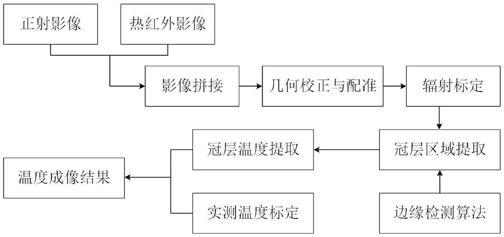
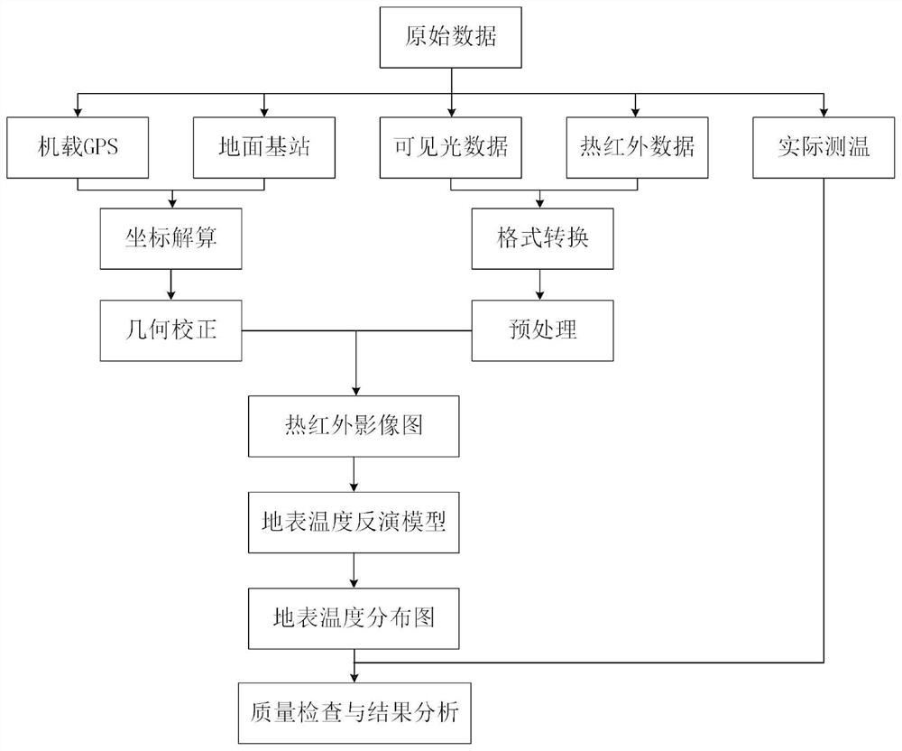
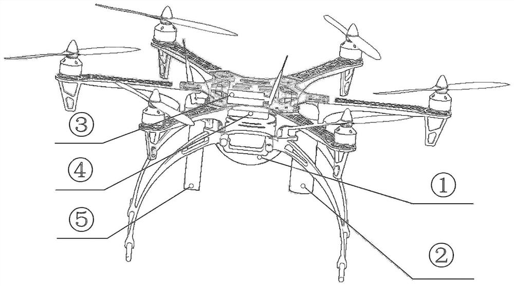
[0035] On the basis of the targeted optimization and upgrade of the above technologies, the thermal infrared imaging system 1 based on the rapid moving platform of the UAV can realize the efficient detection and evaluation of local surface thermal anomalies, and provide data and technical support for the investigation of geothermal resources.

[0036] The problems to be solved by the present invention include:

[0037] (1) Improve system flexibility and optimize application suitability: In view of the low degree of customization of satellite and aerial remote sensing in the data collection and processing stage, the UAV fast moving platform is used for system integration, which ca...


PUM


Abstract

The invention provides a method and system for detecting thermal anomalies on the surface of an unmanned aerial vehicle equipped with infrared remote sensing. The method comprises: acquiring the real-time position of the drone; acquiring the real-time height of the drone; acquiring a thermal infrared image of the ground surface; acquiring a multispectral image of the ground surface; The spectral image is fused into a thermal infrared image map, and the surface temperature inversion module is used to invert the thermal infrared image map into a surface temperature distribution map, and the surface temperature distribution map is sent back to the control terminal. The ground surface thermal field detection method and system provided by the invention provided by the UAV equipped with infrared remote sensing can obtain data in real time at the control terminal, perform rapid preprocessing and ground temperature interpretation, compare the interpretation result with the actual measured temperature, and check the data quality in real time. Adjust the data observation plan in time for areas with poor interpretation effects, so as to realize efficient real-time detection of surface thermal anomalies.

Description

technical field [0001] The invention relates to the technical field of thermal infrared remote sensing, in particular to a method and system for detecting thermal anomalies on the surface of an unmanned aerial vehicle equipped with infrared remote sensing. Background technique [0002] Geothermal resources are clean energy that is renewable, sustainable, and less disturbed by the external environment. Under the deployment of ecological civilization construction and the strategic goal of "carbon peak carbon neutrality", we should give full play to my country's huge reserves of geothermal resources, wide range of applications, Each region is easy to carry out the advantages of developing according to local conditions, increase the intensity of exploration and evaluation, and promote the rational and orderly development of the geothermal industry. Traditional geothermal geological surveys, geophysical and geochemical explorations have a large workload, high cost, and low work ef...

Claims


Application Information

Patent Timeline
Patent Type & Authority Patents(China)
IPC IPC(8): G01J5/48B64C39/02B64D47/00
CPCG01J5/007B64C39/02B64D47/00G01J2005/0077G01J5/485
Inventor 张代磊袁文真周文纳邢一飞朱瑞杰吴文建
Owner CHINESE ACAD OF GEOLOGICAL SCI
Why Eureka
Try Eureka