
Steep cliff three-dimensional modeling method integrating oblique photogrammetry and three-dimensional laser scanning

An oblique photogrammetry and 3D laser technology, applied in the field of 3D modeling of steep cliffs, can solve the problems of 3D model quality and accuracy limitations, difficulty in obtaining 3D point cloud data, etc., to solve the problem of poor data quality and local pull Flowers, good penetrating effect

Inactive Publication Date: 2021-03-09
KUNMING UNIV OF SCI & TECH
View PDF3 Cites 4 Cited by
  • Summary
  • Abstract
  • Description
  • Claims
  • Application Information

AI Technical Summary

Problems solved by technology

[0004] The problem to be solved by the present invention is that it is difficult to obtain complete 3D point cloud data by collecting a single data source with a single device, and the 3D model established by a single data source has certain limitations in quality and accuracy;

Method used


Image

  • Steep cliff three-dimensional modeling method integrating oblique photogrammetry and three-dimensional laser scanning
  • Steep cliff three-dimensional modeling method integrating oblique photogrammetry and three-dimensional laser scanning
  • Steep cliff three-dimensional modeling method integrating oblique photogrammetry and three-dimensional laser scanning

Examples


Embodiment 1

[0039] This embodiment is based on the Marble Gate Scenic Area in Yunnan, which is located in Yangbi County on the west slope of Cangshan Mountain. It is the Cangshan National Geopark. 90°, the cliff is about 450 meters high and more than a thousand meters long.

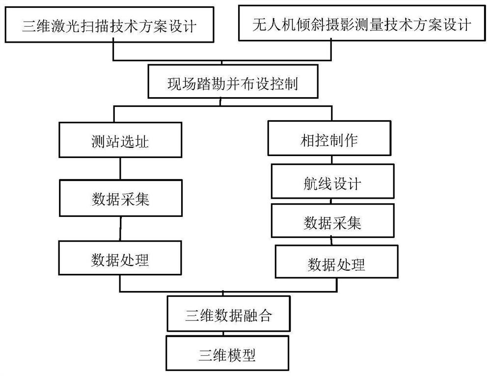
[0040] 1. The data acquisition of ground-based 3D laser scanning technology is divided into the following steps:

[0041] (1) Carry out on-site reconnaissance to determine the main scanning area, and then roughly determine the scanning station for the scanning area;

[0042] (2) Layout the control network, carry out the control measurement, and obtain the coordinates of the control points as the benchmark for calculating the coordinates of the measuring station;

[0043] (3) Place the 3D laser scanner, set the parameters of the instrument, and then collect data; increase or decrease the station according to the actual situation during data collection, and cover the measurement area with fewer viewpoints under the prem...


PUM


Abstract

The invention discloses a steep cliff three-dimensional modeling method integrating oblique photogrammetry and three-dimensional laser scanning. A three-dimensional laser scanning technology is fusedwith point cloud data acquired by low-altitude oblique photogrammetry of an unmanned aerial vehicle, so that the method can be applied to the fields of archaeology, ancient building modeling, deformation monitoring and the like; and acquisition is carried out in a ground and air combined mode, and the two modes can mutually make up for defects of measurement model garland, bottom effect, scanningblind areas mutually shielded front and back and the like.

Description

technical field [0001] The invention belongs to the technical field of geological surveying, and in particular relates to a three-dimensional modeling method for cliffs which integrates oblique photogrammetry and three-dimensional laser scanning. Background technique [0002] Due to its own shape, there are many blind spots in the collection of data sources in the process of building a 3D model of such a special geographical structure due to occlusion, angle and position restrictions. It is difficult to obtain a complete 3D image if only a single device is used to collect a single data source. Point cloud data; the 3D model of geological landforms established only through a single data source has certain limitations in quality and accuracy; therefore, the use of multiple devices, multiple platforms, and multi-angle data source collection and fusion for 3D modeling is a solution The effective approach to the above problems is also a current research hotspot; multi-platform da...

Claims


Application Information

Patent Timeline
IPC IPC(8): G06T17/05G06T17/20G06T7/33G06F17/16G01C11/08G01B11/24G01B11/00
CPCG06T17/05G06T7/344G06T17/20G06F17/16G01C11/08G01B11/002G01B11/24G06T2207/10028
Inventor 杨明龙夏永华唐秀娟吕杰常河宗慧琳侯云花
Owner KUNMING UNIV OF SCI & TECH
Learn More