Side slope deformation monitoring system based on satellite positioning technology

A satellite positioning and deformation monitoring technology, applied in satellite radio beacon positioning system, radio wave measurement system, soil material testing, etc., can solve the problems of low accuracy, high equipment failure rate, insufficient monitoring and feedback, etc., to achieve High positioning accuracy, accurate monitoring results, good monitoring effect

Pending Publication Date: 2020-11-03
祝侁捷
View PDF0 Cites 11 Cited by
  • Summary
  • Abstract
  • Description
  • Claims
  • Application Information

AI Technical Summary

Problems solved by technology

[0002] Slope refers to the slope with a certain slope made on both sides of the roadbed to ensure the stability of the roadbed; slope deformation monitoring, as a technology in civil engineering, has been paid more and more attention, mainly for complex terrain conditions The real-time monitoring of slope deformation in geotechnical engineering plays an important role in the deformation monitoring of slopes and nearby buildings during construction under complex terrain conditions; in addition, it can also be used in the deformation monitoring of structural engineering such as roads and bridges after completion , which plays a very important role in analyzing and evaluating the safety status of structural engineering, verifying the rationality of design, and giving feedback on the design and construction quality of structural engineering; Monitoring the deformation of pit slopes, etc., and then analyzing the stability of the slope, can make timely warnings for landslides; most of the existing slope deformation monitoring systems use mechanical devices, on the one hand, the monitoring and feedback are not timely enough, and on the other hand On the one hand, the failure rate of the equipment is high and the accuracy is low, and the timely and accurate acquisition of slope deformation data will directly affect the timeliness and reliability of the analysis conclusions, and sometimes even seriously affect the emergency response of relevant engineering departments. Therefore there is room for improvement

Method used


Image

  • Side slope deformation monitoring system based on satellite positioning technology
  • Side slope deformation monitoring system based on satellite positioning technology
  • Side slope deformation monitoring system based on satellite positioning technology

Examples


Embodiment Construction

[0022] In order to make the object, technical solution and advantages of the present invention clearer, the present invention will be further described in detail below in combination with specific embodiments and with reference to the accompanying drawings. It should be understood that these descriptions are exemplary only, and are not intended to limit the scope of the present invention. Also, in the following description, descriptions of well-known structures and techniques are omitted to avoid unnecessarily obscuring the concept of the present invention.

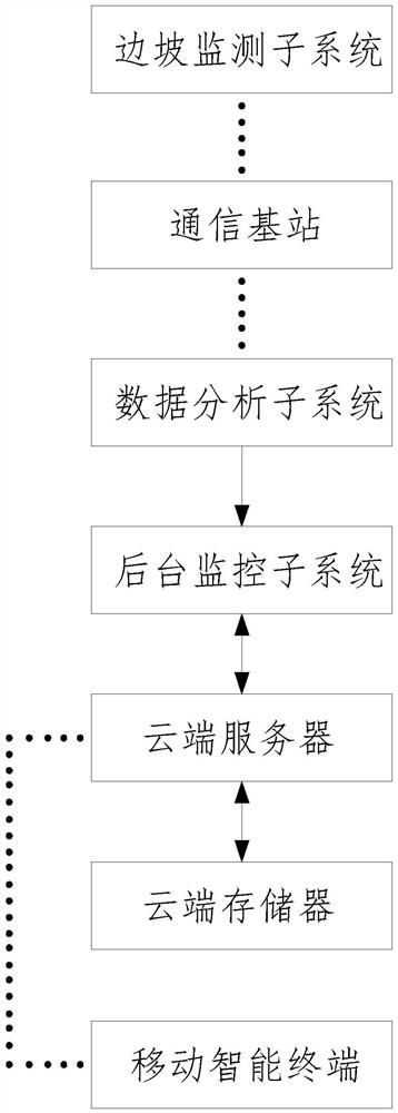
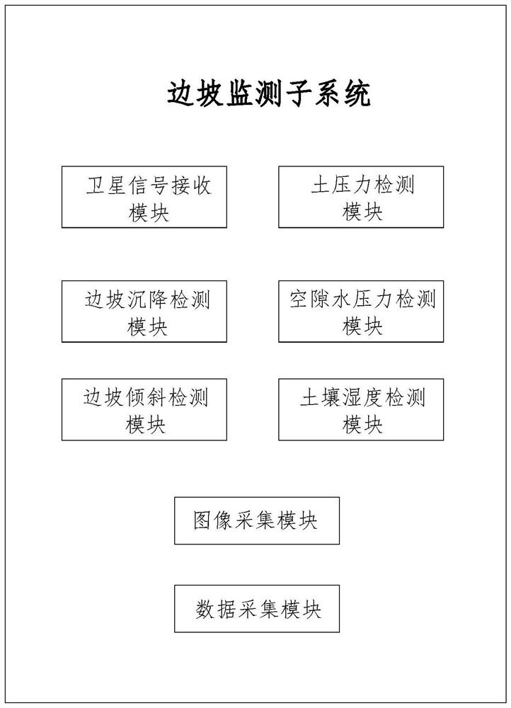
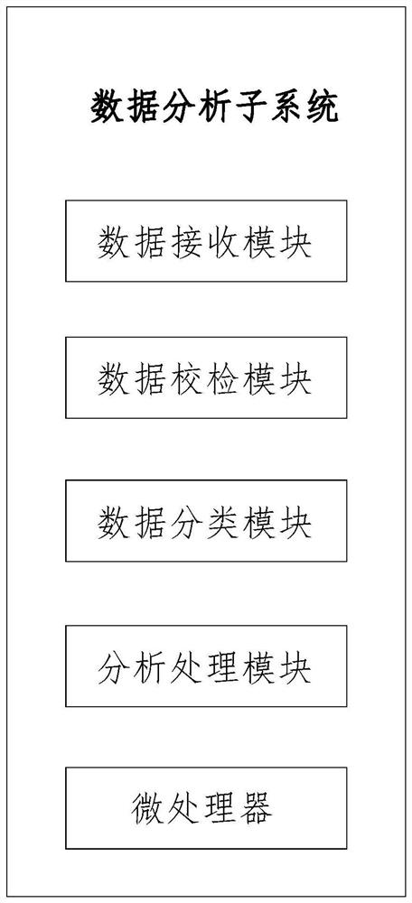
[0023]As shown in Figure 1-4, a slope deformation monitoring system based on satellite positioning technology proposed by the present invention includes a slope monitoring subsystem, a communication base station, a data analysis subsystem, a background monitoring subsystem and a cloud server; the slope The monitoring subsystem and the data analysis subsystem are connected through the communication base station, the data a...


PUM


Abstract

The invention discloses a side slope deformation monitoring system based on a satellite positioning technology. The side slope deformation monitoring system comprises a side slope monitoring subsystem, a communication base station, a data analysis subsystem, a background monitoring subsystem and a cloud server, wherein the slope monitoring subsystem and the data analysis subsystem are in communication connection through the communication base station, the data analysis subsystem is in communication connection with the background monitoring subsystem, and the background monitoring subsystem isin wireless connection with the cloud; the slope monitoring subsystem comprises a satellite signal receiving module, a soil pressure detection module, a slope settlement detection module, a void waterpressure detection module, a slope inclination detection module, a soil humidity detection module and a data acquisition module. Real-time positioning and data analysis are carried out on a slope monitoring part by utilizing satellite positioning and a combined calculation technology, the positioning precision is high, the monitoring effect is good, various data of the slope are detected throughvarious monitoring instruments, an auxiliary effect is achieved on deformation monitoring of the slope, the monitoring effect is further improved, and the monitoring accuracy is improved. Various information of the slope can be known conveniently.

Description

technical field [0001] The invention relates to the technical field of side slope monitoring, in particular to a side slope deformation monitoring system based on satellite positioning technology. Background technique [0002] Slope refers to the slope with a certain slope made on both sides of the roadbed to ensure the stability of the roadbed; slope deformation monitoring, as a technology in civil engineering, has been paid more and more attention, mainly for complex terrain conditions The real-time monitoring of slope deformation in geotechnical engineering plays an important role in the deformation monitoring of slopes and nearby buildings during construction under complex terrain conditions; in addition, it can also be used in the deformation monitoring of structural engineering such as roads and bridges after completion , which plays a very important role in analyzing and evaluating the safety status of structural engineering, verifying the rationality of design, and g...

Claims


Application Information

Patent Timeline
IPC IPC(8): G01S19/42G01S19/14G01S19/03G01N33/24G01C11/00G01B15/06G01W1/02G01W1/14
CPCG01S19/42G01S19/14G01S19/03G01B15/06G01C11/00G01W1/02G01W1/14G01N33/246Y02A90/10
Inventor 祝侁捷
Owner 祝侁捷
Why Eureka
Try Eureka