
Satellite remote sensing identification method and system for stratospheric ozone intrusion into the middle and lower troposphere

A technology for satellite remote sensing and identification methods, applied in the field of satellite remote sensing identification methods and systems, can solve the problems of large errors in low-level model simulation, inability to make accurate judgments, and uneven spatial distribution, and achieve the effect of good consistency

Active Publication Date: 2021-05-11
MINISTRY OF ECOLOGY & ENVIRONMENT CENT FOR SATELLITE APPL ON ECOLOGY ENVIRONMENT
View PDF5 Cites 0 Cited by
  • Summary
  • Abstract
  • Description
  • Claims
  • Application Information

AI Technical Summary

Problems solved by technology

However, at present, due to the lack of vertical profile data of ozone, carbon monoxide and relative humidity at the ground air quality monitoring stations, the scarcity of ground-based remote sensing and sounding data, the coverage is insufficient, and the model simulation has large errors in the middle and lower tropospheres, so it is impossible to make accurate judgments
[0004] At present, only ground air quality station monitoring data, a small amount of ground-based remote sensing and sounding data, and atmospheric models combined with meteorological conditions can be used to judge the process of stratospheric ozone intrusion into the troposphere. However, due to the lack of ozone vertical profile data in ground air quality station monitoring, Including carbon monoxide and relative humidity vertical profile data with anti-phase relationship during the stratospheric ozone intrusion process; although ground-based remote sensing and sounding data can detect the vertical distribution of ozone concentration, due to the scarcity of observation data and uneven spatial distribution, it is impossible to Covering a large-scale range, there is currently no perfect system and method that can accurately identify and judge when and where the event of stratospheric ozone intrusion into the middle and lower troposphere occurs

Method used


Image

  • Satellite remote sensing identification method and system for stratospheric ozone intrusion into the middle and lower troposphere
  • Satellite remote sensing identification method and system for stratospheric ozone intrusion into the middle and lower troposphere
  • Satellite remote sensing identification method and system for stratospheric ozone intrusion into the middle and lower troposphere

Examples


Embodiment

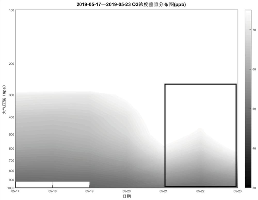
[0122]Set the area to be evaluated as the area where Hangzhou City is located, that is, take Hangzhou City as an example of a specific small area, and retrieve the sky over Hangzhou City from May 21st to May 23rd, 2019 from the State Control Monitoring Station Database and AIRS database. The thermal infrared hyperspectral data, the vertical distribution of ozone concentration in the spectral data is as follows image 3 As shown in , the vertical distribution of carbon monoxide concentration is shown in Figure 4 As shown in , the vertical distribution of relative humidity is shown in Figure 5 shown in;

[0123] The inversion of thermal infrared hyperspectral data is carried out through the following sub-steps:

[0124] Sub-step 1, substituting X directly obtained from thermal infrared hyperspectral data into formula (1) to obtain the initial radiation amount Y, and then substituting the obtained radiation amount Y and this X into formula (2) to obtain the The objective fun...


PUM


Abstract

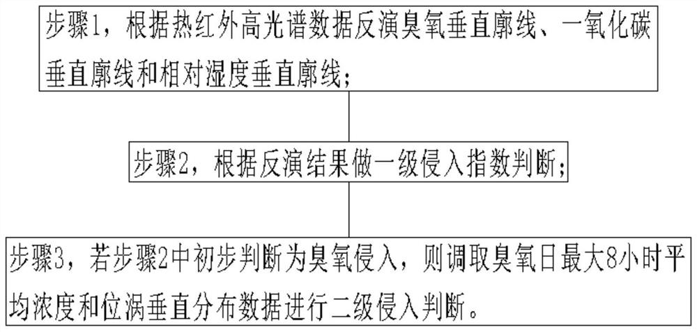
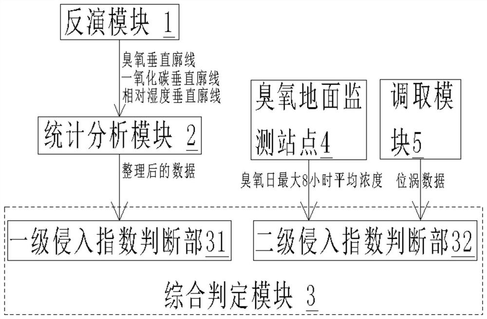
The invention discloses a satellite remote sensing identification method and system for stratospheric ozone intrusion into the middle and lower layers of the troposphere. Simultaneous inversion of thermal infrared hyperspectral data to obtain vertical profile data of carbon monoxide and relative humidity, considering consistency issues, using thermal infrared hyperspectral data to simultaneously invert vertical profiles of ozone, carbon monoxide and relative humidity, combined with ground monitoring station data and position The vertical distribution of eddies can be used to accurately judge the event of stratospheric ozone intrusion into the middle and lower troposphere, and provide data support for the analysis of the causes of near-surface ozone and pollution control.

Description

technical field [0001] The invention relates to the field of ozone detection, in particular to a satellite remote sensing identification method and system for stratospheric ozone intruding into the middle and lower layers of the troposphere. Background technique [0002] In the atmosphere, 90% of ozone is concentrated in the stratosphere, forming a protective layer that reduces the ultraviolet radiation from the sun reaching the earth's surface, and 10% of ozone exists in the troposphere. Therefore, in order to analyze the causes of regional ozone pollution and control the ozone concentration near the ground, in addition to considering local emissions, it is also necessary to monitor the vertical distribution of ozone concentration in the large-scale space atmosphere, and further identify and judge the impact of stratospheric ozone intrusion into the middle and lower troposphere. [0003] The environment of high temperature, low humidity and low wind speed is conducive to oz...

Claims


Application Information

Patent Timeline
Patent Type & Authority Patents(China)
IPC IPC(8): G01N21/3504
CPCG01N21/3504
Inventor 马鹏飞张建辉毛慧琴厉青赵少华王中挺张玉环周春艳张连华胡奎伟王玉王延龙陈辉陈翠红赵爱梅张丽娟翁国庆
Owner MINISTRY OF ECOLOGY & ENVIRONMENT CENT FOR SATELLITE APPL ON ECOLOGY ENVIRONMENT
Learn More