
Navigation satellite orbit determination tracking station optimization algorithm

A technology of navigation satellites and tracking stations, which is applied in the field of satellite orbit calculation, can solve problems such as inapplicability, and achieve the effect of improving calculation efficiency

Active Publication Date: 2020-09-11
NAT TIME SERVICE CENT CHINESE ACAD OF SCI
View PDF2 Cites 2 Cited by
  • Summary
  • Abstract
  • Description
  • Claims
  • Application Information

AI Technical Summary

Problems solved by technology

[0003] The traditional method of selecting orbit determination tracking stations is to select a certain number of evenly distributed tracking stations around the world based on experience, but there are few related methods to describe the distribution of a certain tracking station through quantitative methods, especially for the current Beidou satellites. Navigation system (BDS), its satellite constellation contains three types of satellites, and the satellite constellation is not evenly distributed globally, which leads to the traditional method of selecting orbit determination tracking stations evenly around the world based on experience, which is not applicable to BDS system satellite orbit determination

Method used


Image

  • Navigation satellite orbit determination tracking station optimization algorithm
  • Navigation satellite orbit determination tracking station optimization algorithm
  • Navigation satellite orbit determination tracking station optimization algorithm

Examples


Embodiment 1

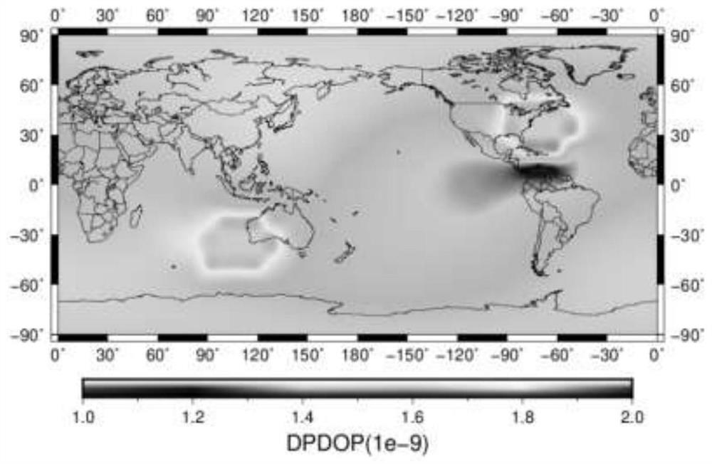
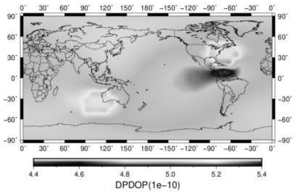
[0066] The main content of embodiment one is how to determine the DOP value of kinetic parameter, concrete method is as follows:

[0067] In the parameter estimation process, the DOP value of the parameter is often used to evaluate the accuracy of the parameter solution. In the orbit determination calculation of navigation satellites based on the observation data of ground tracking stations, the DOP value of dynamic parameters can be obtained by the following method.

[0068] For the GNSS observation of the ground tracking station, in the case of ignoring various errors and only studying the station distribution structure, the observation model can be simply expressed as:

[0069]

[0070] In the formula: ρ represents the geometric distance between the satellite and the station, i represents the satellite number; (X i , Y i ,Z i ) represents the three-dimensional coordinates of the satellite, (x, y, z) represents the three-dimensional coordinates of the tracking station,...

Embodiment 2

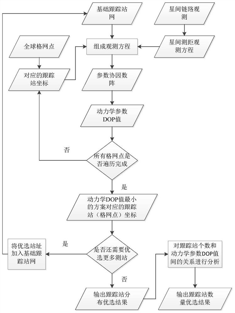
[0098] Embodiment two is based on the DOP value design navigation satellite orbit determination tracking station optimization algorithm of the dynamic parameters determined in embodiment one, and the specific content is as follows:

[0099] 1. Determination of the location of the tracking station

[0100] 11. Select a number of basic tracking station networks.

[0101] 12. Verify epoch by epoch whether each satellite and each station in the basic tracking station network meet the observation requirements (for example, the observation elevation angle is greater than 5°), and based on formula (4), establish an observation equation for the observation that meets the requirements.

[0102] 13. When analyzing the optimal distribution of ground tracking stations in the inter-satellite link state, according to the inter-satellite link routing algorithm (this algorithm has been applied in engineering, this patent will not discuss in depth), based on formula (9) The epoch establishes ...


PUM


Abstract

The invention relates to the technical field of satellite orbit calculation, in particular to a navigation satellite orbit determination tracking station optimization algorithm, which utilizes indexesto quantitatively analyze the distribution advantages and disadvantages of different tracking stations and the number saturation of orbit determination tracking stations, and provides technical support for selection of satellite orbit determination tracking stations of various navigation systems and site selection of a core reference station. According to the algorithm, the positions and the number of the navigation satellite orbit determination ground tracking stations can be optimized on the premise that no ground tracking station observation data exists, compared with an existing trackingstation distribution optimization algorithm, the calculation efficiency is improved, an optimization algorithm of the number of the tracking stations is added, and meanwhile fusion analysis of multiple types of observation values can be compatible; moreover, the optimization algorithm designed by the invention is universally suitable for different navigation systems, and is also suitable for optimization of the orbit determination tracking station during fusion processing of multiple types of observation values.

Description

technical field [0001] The invention relates to the technical field of satellite orbit calculation, in particular to a navigation satellite orbit determination and tracking station optimization algorithm. Background technique [0002] For any spacecraft, precise orbit determination is one of the primary tasks for the stable operation of the spacecraft. For the global navigation satellite system (GNSS), the satellite orbit error is one of the main error sources of observation, and the orbit accuracy directly affects the user's navigation and positioning accuracy. Hot issues of concern to the majority of users. Due to the high-precision orbit determination requirements of GNSS navigation satellites, in practical applications, the GNSS measurement data collected by ground tracking stations are mainly used to establish observation equations, and the satellite dynamic parameters are solved by parameter estimation methods. During the calculation process, the geometric strength o...

Claims


Application Information

Patent Timeline
IPC IPC(8): G01S19/01G06F30/20G06F111/10
CPCG01S19/01G06F30/20G06F2111/10Y02D30/70
Inventor 张睿涂锐卢晓春韩军强范丽红张鹏飞洪菊刘金海王星星
Owner NAT TIME SERVICE CENT CHINESE ACAD OF SCI
Learn More