Surveying and mapping instrument, surveying and mapping method and device, terminal device and storage medium

An instrument and pre-positioning technology, applied in the field of surface surveying and mapping, can solve the problems of low efficiency and precision of aerial surveying and mapping, and achieve the effects of efficiency and precision improvement, high-precision surveying and mapping, and efficient surveying and mapping

Active Publication Date: 2020-06-12
CHANGCHUN INST OF OPTICS FINE MECHANICS & PHYSICS CHINESE ACAD OF SCI
View PDF11 Cites 3 Cited by
  • Summary
  • Abstract
  • Description
  • Claims
  • Application Information

AI Technical Summary

Problems solved by technology

[0004] In view of this, an embodiment of the present invention provides a surveying and mapping instrument, a surveying and mapping method and device, a terminal device, and a storage medium to solve the problem of low efficiency and accuracy of aerial surveying and mapping in the prior art

Method used


Image

  • Surveying and mapping instrument, surveying and mapping method and device, terminal device and storage medium
  • Surveying and mapping instrument, surveying and mapping method and device, terminal device and storage medium
  • Surveying and mapping instrument, surveying and mapping method and device, terminal device and storage medium

Examples


Embodiment Construction

[0031] In the following description, specific details such as specific system structures and technologies are presented for the purpose of illustration rather than limitation, so as to thoroughly understand the embodiments of the present invention. It will be apparent, however, to one skilled in the art that the invention may be practiced in other embodiments without these specific details. In other instances, detailed descriptions of well-known systems, devices, circuits, and methods are omitted so as not to obscure the description of the present invention with unnecessary detail.

[0032] In order to illustrate the technical solutions of the present invention, specific examples are used below to illustrate.

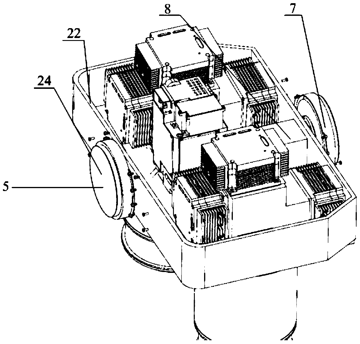
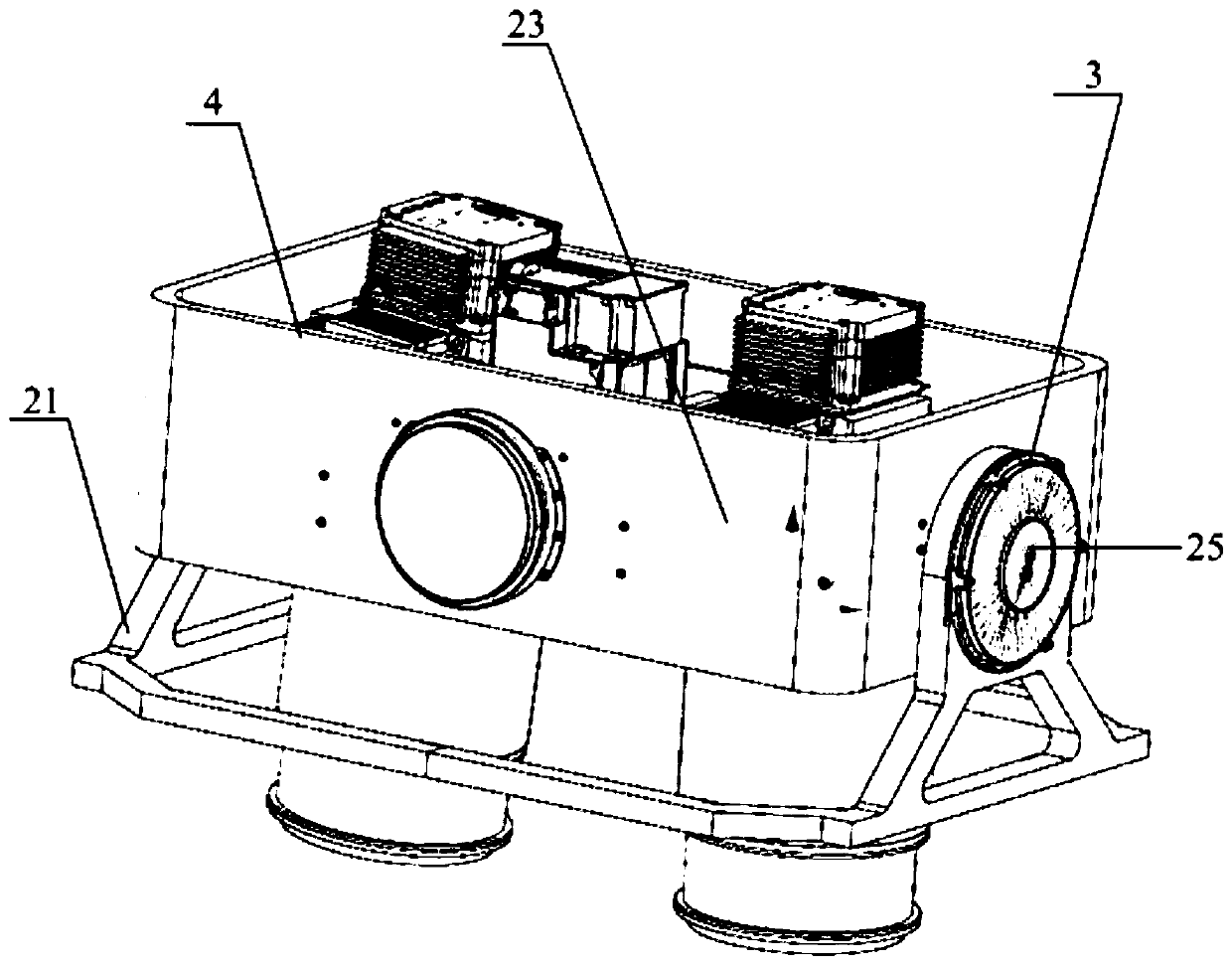
[0033] The first embodiment of the present invention provides a surveying and mapping instrument, which is mounted on a flying object for ground surface surveying and mapping. Such as Figure 1-3 As shown, the surveying instrument may include a camera 1 and a composit...


PUM


Abstract

The invention is applicable to the field of surface surveying and mapping, and provides a surveying and mapping instrument, a surveying and mapping method and device, a terminal device and a storage medium, wherein the surveying and mapping instrument comprises a camera; and a composite frame on which the camera is installed and which comprises a machine body, an inner machine body frame and an outer machine body frame, wherein the inner machine body frame is used for driving the camera to rotate in a pitching direction, and the outer machine body frame is used for driving the camera to rotatein a transverse rolling direction so as to achieve the two-dimensional scanning imaging of the ground surface. The surveying and mapping instrument can provide a working mode based on two-dimensionalscanning, so that the large-base-height-ratio inclined wide-width imaging in a single flight strip can be achieved, namely, the large-inclination, wide-width, efficient and high-precision surveying and mapping in the single flight strip are achieved by combining the flight direction revisit and the large-angle whisk-broom imaging in the direction perpendicular to the flight direction, and accordingly the aerial surveying and mapping efficiency and precision are both improved.

Description

technical field [0001] The invention belongs to the field of surface surveying and mapping, and in particular relates to a surveying and mapping instrument, a surveying and mapping method and device, terminal equipment, and a storage medium. Background technique [0002] In order to realize high-altitude long-distance large-scale high-precision surveying and mapping, a surveying and mapping camera with a long focal length is required. At present, the focal length of existing surveying and mapping cameras at home and abroad is relatively short, generally no more than 200mm, which not only cannot meet the needs of high-altitude and long-distance high-precision surveying and mapping, but also has low efficiency and accuracy. It needs to work vertically and overhead, and cannot be applied to tilt surveying and mapping. [0003] Therefore, it is necessary to improve the existing aerial surveying and mapping technology in order to improve the efficiency and accuracy of aerial sur...

Claims


Application Information

Patent Timeline
IPC IPC(8): G01C11/02G01S17/89G01S7/481G06T7/70G06T11/60
CPCG01C11/025G01S7/4817G01S17/89G06T11/60G06T7/70
Inventor 丁亚林远国勤郑丽娜张洪文
Owner CHANGCHUN INST OF OPTICS FINE MECHANICS & PHYSICS CHINESE ACAD OF SCI
Why Eureka
Try Eureka