Earthwork balance correction calculation method for low-altitude oblique photogrammetry technology

A technology of tilt photogrammetry and balance correction, applied to measurement devices, instruments, etc., can solve problems such as inability to guide on-site construction, differences in earthwork balance data, and overall deviation of point cloud data, etc., to reduce equipment measurement deviation, reduce The effect of overall deviation and high degree of reduction

Pending Publication Date: 2020-06-09
CHINA CONSTR FOURTH ENG DIV
View PDF5 Cites 6 Cited by
  • Summary
  • Abstract
  • Description
  • Claims
  • Application Information

AI Technical Summary

Problems solved by technology

With the advancement of science and technology, there are more and more cases of low-altitude oblique photogrammetry applied to earthwork balance calculations. It solves the problems of insufficient measurement points and long measurement period. Due to the influence of various factors, there is an overall deviation of the point cloud data, which makes the earthwork balance data and the actual site have a large difference, which cannot guide the site construction well.

Method used


Image

  • Earthwork balance correction calculation method for low-altitude oblique photogrammetry technology

Examples


Embodiment Construction

[0014] The following will clearly and completely describe the technical solutions in the embodiments of the present invention with reference to the accompanying drawings in the embodiments of the present invention. Obviously, the described embodiments are only some, not all, embodiments of the present invention. Based on the embodiments of the present invention, all other embodiments obtained by persons of ordinary skill in the art without making creative efforts belong to the protection scope of the present invention.

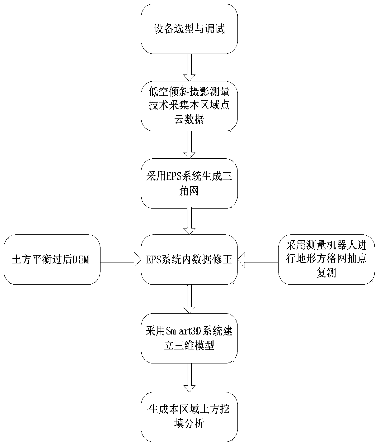
[0015] Examples of the invention: see figure 1 , an earthwork balance correction calculation method for low-altitude oblique photogrammetry technology, comprising the following steps:

[0016] 1. Equipment selection and debugging

[0017] A drone with a flight height of 500m, a flight range of within 3000m, a hovering accuracy of ±0.1m, and an RTKGNSS function that can generate 3D point cloud data is used. The measurement frequency shall not be lower than 10...


PUM


Abstract

The invention discloses an earthwork balance correction calculation method for a low-altitude oblique photogrammetry technology. According to the method, a low-altitude flight platform is adopted to carry an aerial photography sensor to collect ground image data of an earthwork balance area and scanned point cloud data; performing modeling processing on the point cloud data through three-dimensional modeling software, and importing the model into an EPS system to generate a triangulation network; meanwhile, adopting a measuring robot to carry out point extraction re-measurement on a characteristic area to form correction data, importing correction elevation value data into the EPS system to correct a triangulated network, and finally, setting a DEM (digital elevation model) after earthworkbalance in the EPS system according to design and construction requirements to serve as a digging and filling analysis basis. According to the method, the manual intervention is reduced, the workingefficiency is improved, the model scene reduction degree is high, the earthwork balance working data is restored to approach the field reality, and the method has high reference and guidance effects on the field construction.

Description

technical field [0001] The invention relates to an earthwork balance correction calculation method for low-altitude oblique photogrammetry technology, and belongs to the technical field of earthwork construction in road and bridge engineering. Background technique [0002] In the construction process of infrastructure projects such as roads and bridges, there are often large-scale earthwork excavation and filling earthwork balance work. The original GPS surveying and mapping has defects such as insufficient number of measurement points, large data deviation, and long measurement cycle. With the advancement of science and technology, there are more and more cases of low-altitude oblique photogrammetry applied to earthwork balance calculations. It solves the problems of insufficient measurement points and long measurement period. Due to the influence of factors, there is an overall deviation of the point cloud data, which makes the earthwork balance data and the actual site ha...

Claims


Application Information

Patent Timeline
Patent Type & Authority Applications(China)
IPC IPC(8): G01C25/00
CPCG01C25/00
Inventor 董浩晏克珍谢明康
Owner CHINA CONSTR FOURTH ENG DIV
Why Eureka
Try Eureka