Map generation method and device for road segment and related system

A map generation and road technology, applied in the field of navigation, can solve the problem of not being able to obtain which lane of the vehicle and which lane it should take, affecting the map display effect, and appearing gaps.

Active Publication Date: 2020-06-05
SHENYANG MXNAVI CO LTD
View PDF8 Cites 2 Cited by
  • Summary
  • Abstract
  • Description
  • Claims
  • Application Information

AI Technical Summary

Problems solved by technology

Since the navigation map does not realize accurate map display at the lane level of the road, it is impossible to obtain which lane the vehicle is in at the current position and which lane it should take during navigation, so it is impossible to realize lane-level navigation of the vehicle
At the same time, when generating a road map at the lane level, due to the size limit of the road map, the road map is generated and displayed according to the road map area (Tile). When making a map, it will result in incomplete road drawing or gaps in the road map area to be generated, which will affect the map display effect

Method used


Image

  • Map generation method and device for road segment and related system
  • Map generation method and device for road segment and related system
  • Map generation method and device for road segment and related system

Examples


Embodiment 1

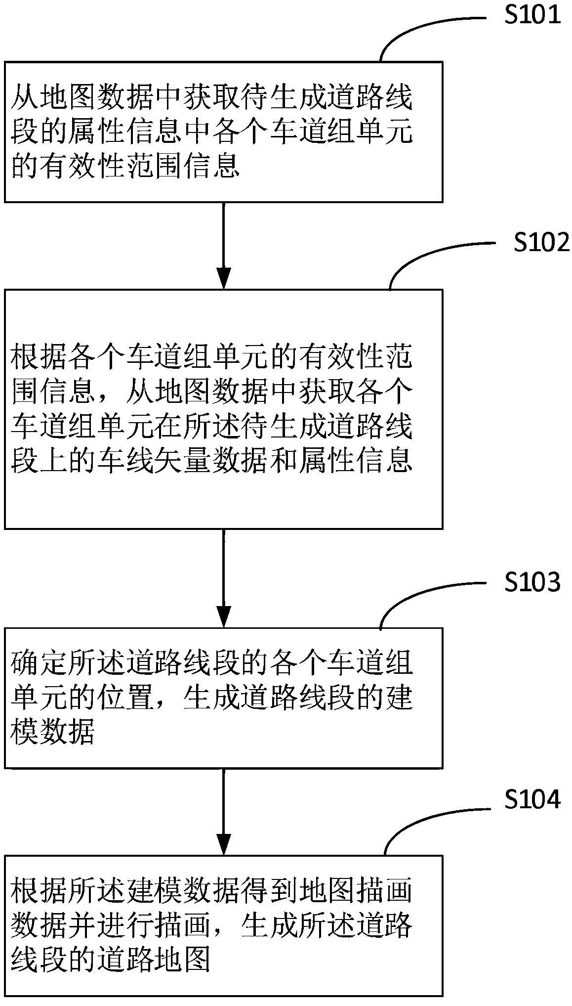
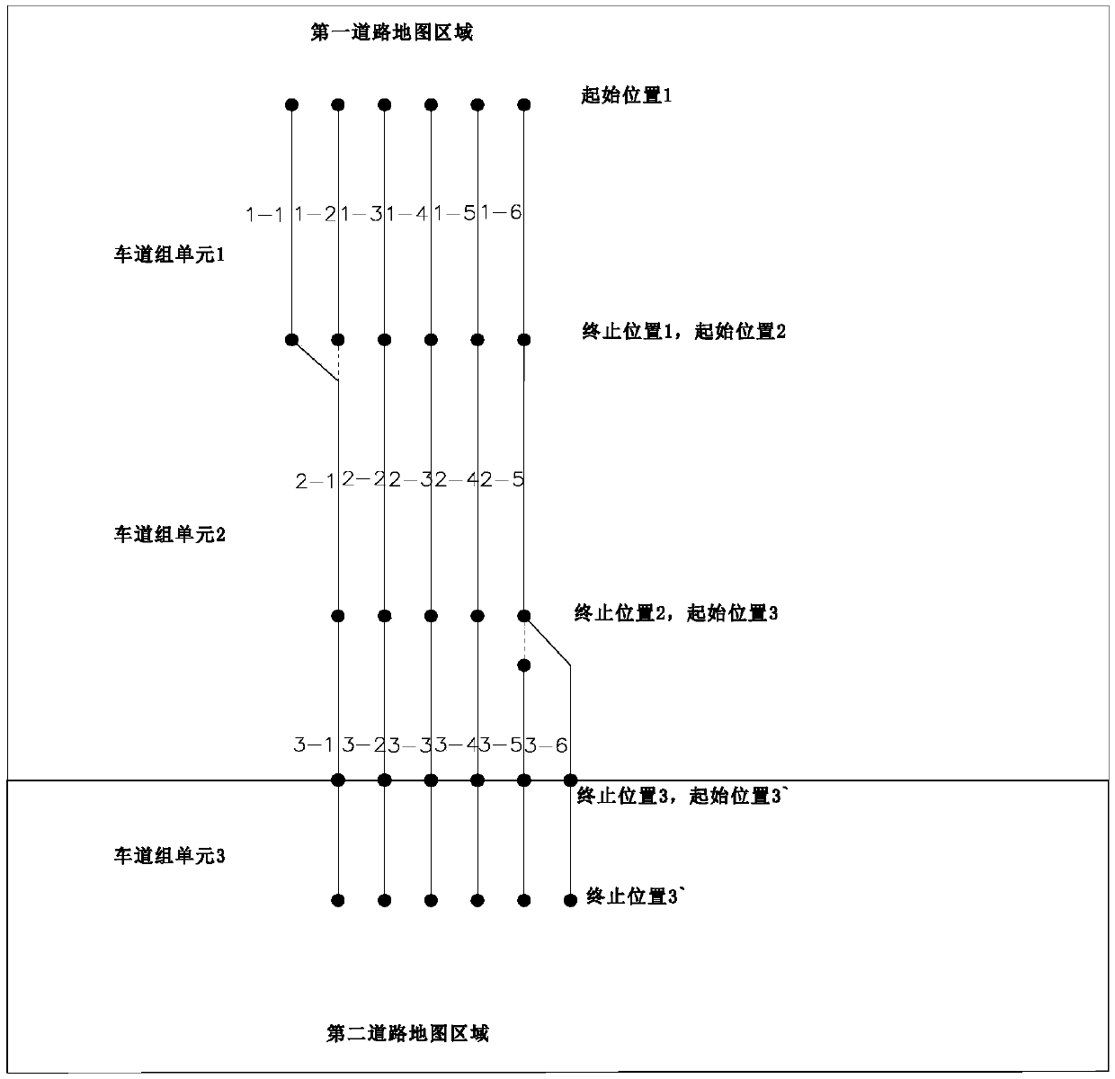
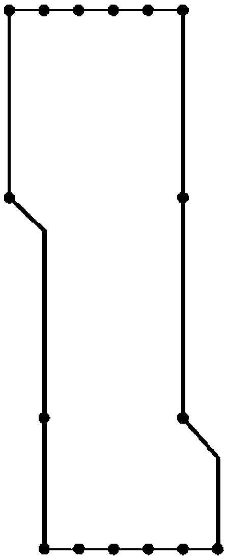
[0090] Embodiment 1 of the present invention provides a method for generating a map of road segments in a road map area, wherein the road segment to be generated includes lane group units crossing the road map area, and the lane group units spanning the road map area are Lane group units of two adjacent road map areas, the process refers to figure 1 shown, including:

[0091] S101: Obtain the validity range information of each lane group unit in the attribute information of the road segment to be generated from the map data;

[0092]S102: According to the validity range information of each lane group unit, obtain the lane vector data and attribute information of each lane group unit on the road segment to be generated from the map data;

[0093] S103: Determine the position of each lane group unit of the road segment to be generated, and generate modeling data of the road segment;

[0094] S104: Obtain and draw map drawing data according to the modeling data to generate a ro...

Embodiment 2

[0184] Based on the same inventive concept, an embodiment of the present invention also provides a road segment map generating device, which can be set in a navigation server or a navigation terminal, and the structure of the device is as follows Figure 9 shown, including:

[0185] The first acquisition module 101 is configured to acquire vehicle line vector data and attribute information of each lane group unit of the road segment in the first road map area from map data;

[0186] The second acquisition module 102 is used to obtain the lane group unit crossing the road map area in the adjacent second road map area from the map data according to the feature index information in the attribute information of the lane group unit crossing the road map area The vehicle line vector data and attribute information;

[0187] Modeling data generation module 103, is used for determining the position of each lane group unit of described road segment, generates the modeling data of road ...

Embodiment 3

[0215] Based on the same inventive concept, an embodiment of the present invention also provides a map generation system for road segments, referring to Figure 10 shown, including:

[0216] Map storage server 1, for storing map data;

[0217] The terminal device 2 includes the road segment map generation device 10 described in any of the above embodiments, configured to generate and display a road map of the road segment.

[0218] The implementation of the road map generation system provided in the embodiment of the present invention is similar to the technical problem solved by the road map generation method described in the first embodiment. For specific implementation, please refer to the description of the road map generation method in the above embodiment. Here, No longer.


PUM


Abstract

The invention discloses a map generation method and device for a road segment and a related system. The method comprises the steps of obtaining validity range information of each lane group unit in attribute information of a to-be-generated road segment from map data, according to the validity range information of each lane group unit, obtaining vehicle line vector data and attribute information of each lane group unit on the to-be-generated road segment from map data, determining the position of each lane group unit of the to-be-generated road segment, and generating modeling data of the roadsegment, and obtaining map drawing data according to the modeling data and drawing to generate a road map of the road segment. The generated road map of the road segment can display a complete map ofthe road segment in the road map area to which the road segment belongs, the phenomenon of lane line missing or lane butt joint gaps is avoided, lane-level map display of the generated road map is achieved, the map display fineness is improved, and lane information more conforming to a real road is displayed.

Description

technical field [0001] The invention relates to the technical field of navigation, in particular to a method, device and related system for generating a road segment map. Background technique [0002] When the existing navigation map is displayed on the map, it only shows the basic single-line image of the road and the navigation route, but cannot show the lane condition of the road. Therefore, the display fineness of the road is insufficient. With the rapid development of the automobile industry, the car navigation system has become an indispensable and important link in the car driving assistance technology and automatic driving technology. Since the navigation map does not realize accurate map display at the lane level of the road, it is impossible to obtain which lane the vehicle is in at the current position and which lane it should take during navigation, so it is impossible to realize lane-level navigation of the vehicle . At the same time, when generating a road ma...

Claims


Application Information

Patent Timeline
Patent Type & Authority Applications(China)
IPC IPC(8): G01C21/32G01C21/36
CPCG01C21/32G01C21/367G01C21/3658
Inventor 赖克
Owner SHENYANG MXNAVI CO LTD
Why Eureka
Try Eureka