
GIS-based information visualization system

An information module and meteorological information technology, applied in the field of GIS-based information visualization system, can solve problems such as lack of monitoring, and achieve the effect of reducing losses and quick recovery

Inactive Publication Date: 2020-03-06
STATE GRID JIANGSU ELECTRIC POWER CO LTD NANTONG POWER SUPPLY BRANCH
View PDF0 Cites 4 Cited by
  • Summary
  • Abstract
  • Description
  • Claims
  • Application Information

AI Technical Summary

Problems solved by technology

Visualization technology has been widely used in the process of power system informatization, but there is still a lack of comprehensive and systematic monitoring of multiple links in the power system that combines GIS and visualization technology in the operation of power companies and power grids

Method used


Image

  • GIS-based information visualization system

Examples


Embodiment Construction

[0022] The specific implementation of the GIS-based information visualization system of the present invention will be described in detail below in conjunction with the accompanying drawings.

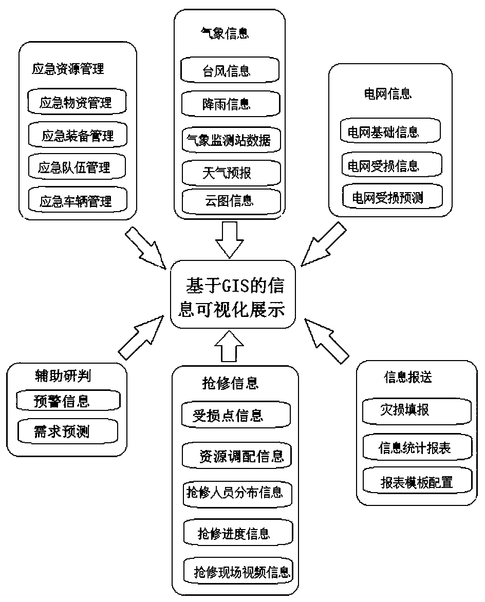
[0023] The GIS-based information visualization system provided by the present invention, such as figure 1 The display includes: information display visual display module, weather information module, emergency resource management module, power grid information module, auxiliary research and judgment module, emergency repair information module and information submission module. The information display visual display module is respectively connected with the weather information module, emergency resource management module, power grid information module, auxiliary research and judgment module, emergency repair information module and information reporting module. The information display visual display module is a large-screen display module.

[0024] The weather information module includes a...


PUM


Abstract

The invention relates to a GIS-based information visualization system. The GIS-based information visualization system comprises a meteorological information module, an emergency resource management module, a power grid information module, an auxiliary research and judgment module, a first-aid repair information module and an information reporting module which are in communication connection with an information display visual display module, wherein meteorological information, resource management information, power grid information, first-aid repair / maintenance information and auxiliary research and judgment information form a multifunctional sharing mechanism of a visual platform, and optimal scheduling, optimal monitoring, minimum cost and load balancing of a power system are achieved. Emergency disposal and commanding are more accurate and efficient, and a situation judgment, prediction analysis and emergency commanding integrated technical supporting platform is formed, and a linkage mechanism is established, and quick power recovery is guaranteed, and losses are reduced to the maximum extent.

Description

technical field [0001] The invention belongs to the field of power grid monitoring, and in particular relates to a GIS-based information visualization system. Background technique [0002] Geographic Information System (GIS, Geographic Information System) plays an important role in power production and management, and plays an important role in distribution network management. Power grid resources are widely distributed on each node in the coverage area, and geographic coordinates have become an important attribute of power grid equipment. Therefore, the digitalization and informatization of the power grid cannot be separated from the support of GIS technology; Used in the daily management of the company. The development of electric power informatization has gone from the initial application of traditional databases to geographic information systems. At the end of the last century, electric power systems began to integrate various technologies such as geographic information...

Claims


Application Information

Patent Timeline
Patent Type & Authority Applications(China)
IPC IPC(8): G06F16/26G06F16/29
CPCG06F16/26G06F16/29
Inventor 黄峰代克丽马骏吉宇钱霜秋
Owner STATE GRID JIANGSU ELECTRIC POWER CO LTD NANTONG POWER SUPPLY BRANCH
Learn More