A multi-scale near-surface tomographic velocity modeling method and modeling system
A velocity modeling, multi-scale technology, applied in the field of oil and gas exploration, can solve problems such as low resolution, unstable matrix solution, limited ability to improve accuracy, etc., to improve inversion accuracy, improve inversion efficiency, and reduce memory usage. Effect
- Summary
- Abstract
- Description
- Claims
- Application Information
AI Technical Summary
Problems solved by technology
Method used
Image
Examples
Embodiment
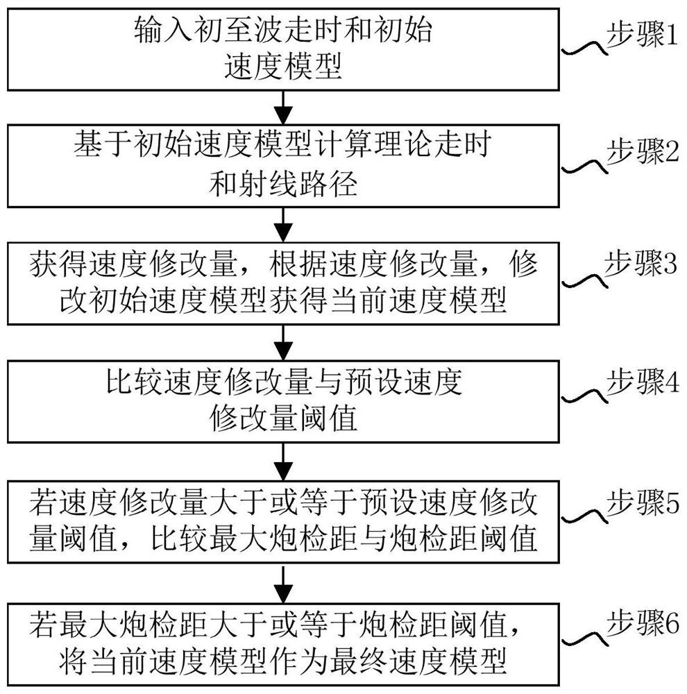
[0085] figure 1 A flow chart of a multi-scale near-surface tomographic velocity modeling method according to an embodiment of the present invention is shown.
[0086] Such as figure 1 As shown, the multi-scale near-surface tomographic velocity modeling method includes:
[0087] Step 1: Input first arrival travel time and initial velocity model;
[0088] Step 2: Calculate the theoretical travel time and ray path based on the initial velocity model;
[0089] Among them, the theoretical travel time and ray path are calculated by ray tracing method;
[0090] Step 3: Obtain the velocity modifier, and modify the initial velocity model to obtain the current velocity model according to the velocity modifier;
[0091] Among them, the current velocity model is obtained through the model iteration method, and the formula used in the model iteration method is:
[0092] m l+1 = m l +α l p l (1)
[0093] Among them, m l+1 is the current velocity model, m l is the initial veloci...
PUM
 Abstract
Description
Claims
Application Information
 - R&D
- Intellectual Property
- Life Sciences
- Materials
- Tech Scout
- Unparalleled Data Quality
- Higher Quality Content
- 60% Fewer Hallucinations
Browse by: Latest US Patents, China's latest patents, Technical Efficacy Thesaurus, Application Domain, Technology Topic, Popular Technical Reports.
© 2025 PatSnap. All rights reserved.Legal|Privacy policy|Modern Slavery Act Transparency Statement|Sitemap|About US| Contact US: help@patsnap.com


