
Color reconstruction method for optical remote sensing image based on convolutional neural network

An optical remote sensing image and convolutional neural network technology, applied in the field of image processing, can solve the problems of image color reconstruction, unsuitable images, and large amount of calculations, and achieve the effect of avoiding color inconsistency and good color reconstruction effect

Active Publication Date: 2020-02-04
XIDIAN UNIV
View PDF4 Cites 4 Cited by
  • Summary
  • Abstract
  • Description
  • Claims
  • Application Information

AI Technical Summary

Problems solved by technology

For the color reconstruction of Bayer format images, scholars at home and abroad have proposed many practical methods. Among these methods, the algorithm with better color reconstruction effect requires more calculations and takes up more hardware resources. Xu Shaoxiong et al. The low-complexity Bayer image color reconstruction method proposed in the core journal first uses the Hamilton-Adam algorithm to pre-interpolate the Bayer image and obtain the color difference channel; then, by calculating the comprehensive gradient factor for judging the interpolation direction in the 5×5 template, Re-update the missing pixel value of the G channel; finally use the reconstructed G channel to find the missing R and B channel colors. This method can reduce the occupation of hardware resources and is easy to implement in hardware, but it can only be used for color reconstruction of Bayer format images. Not suitable for images taken by remote sensing satellites

Method used


Image

  • Color reconstruction method for optical remote sensing image based on convolutional neural network
  • Color reconstruction method for optical remote sensing image based on convolutional neural network
  • Color reconstruction method for optical remote sensing image based on convolutional neural network

Examples


Embodiment Construction

[0026] The embodiments and effects of the present invention will be further described below in conjunction with the accompanying drawings.

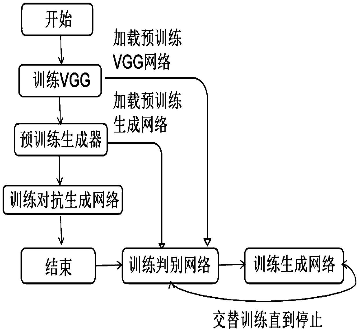
[0027] refer to figure 1 , the specific implementation steps of the present invention are as follows:

[0028] Step 1, obtain remote sensing image classification dataset Y and color remote sensing image X1.

[0029] Download the remote sensing image classification dataset Y and color remote sensing image X1 required for the experiment from the website;

[0030] The remote sensing image classification dataset contains 35 different categories, namely town, water flow, storage room, sparse forest, snow mountain, shrub, sea, sapling, beach, shelter forest, river, residential area, pipeline, parking lot, mountain, ocean, red Trees, lake shores, barren land, highways, green farms, forests, dry farms, deserts, dams, intersections, containers, coastlines, urban buildings, bridges, bare land, avenues, agricultural greens, airplanes and airport r...


PUM


Abstract

The invention discloses a color reconstruction method for an optical remote sensing image based on a convolutional neural network, and mainly solves the problem that the color of a ground object cannot be truly reflected when color reconstruction is carried out on the remote sensing image by the existing method. According to the scheme, the method comprises the following steps of downloading a public remote sensing image classification data set and a color remote sensing image from internet; constructing a training set and a test set on the remote sensing image classification data set, and training a classification network by using the training set to extract remote sensing ground object features; utilizing the color remote sensing images to respectively obtain gray scale remote sensing images and color remote sensing images with abnormal colors, and training a generative adversarial network composed of a generative network and a discrimination network by using the gray scale remote sensing images and the color remote sensing images with abnormal colors to obtain a trained generative network; and inputting the grayscale remote sensing image into the trained generative network to obtain a color remote sensing image after color reconstruction. According to the invention, color reconstruction of the remote sensing image is realized, and the obtained color image can truly reflectground object features and can be used for ground object classification and target detection tasks of the remote sensing image.

Description

technical field [0001] The invention belongs to the technical field of image processing, and in particular relates to an image color reconstruction method, which can be used for classification of remote sensing objects and detection, positioning and tracking of remote sensing targets. Background technique [0002] Remote sensing data is a list of digital data directly obtained from remote sensors, and color display is a very important technology in order to make the content intuitive and easy to understand. Compared with grayscale remote sensing images, color images can improve the recognition of details by the human eye, and are a very important image enhancement technology. Color images contain information in three dimensions. Compared with single-channel grayscale images, more information can be obtained. Therefore, in the application of remote sensing data, the classification of remote sensing ground objects and the detection, positioning, and tracking of remote sensing ...

Claims


Application Information

Patent Timeline
Patent Type & Authority Applications(China)
IPC IPC(8): G06T11/00G06N3/04G06N3/08
CPCG06T11/001G06N3/08G06N3/084G06N3/045
Inventor 侯彪柳阳飞焦李成马文萍马晶晶杨淑媛
Owner XIDIAN UNIV
Learn More