
Airborne direction finding and positioning method

A direction-finding positioning and direction-finding technology, which is used in positioning, measuring devices, radio wave measurement systems, etc., can solve the problem of not considering the different direction-finding accuracy of linear array interferometers, the divergence of positioning initial value selection algorithms, and the complexity of calculating Jacobian matrices. and other problems to achieve the effect of avoiding derivative operation, small positioning error, and avoiding multiple conversions

Pending Publication Date: 2019-11-15
10TH RES INST OF CETC
View PDF2 Cites 2 Cited by
  • Summary
  • Abstract
  • Description
  • Claims
  • Application Information

AI Technical Summary

Problems solved by technology

This method is suitable for motorized platforms, but the calculation of the Jacobian matrix is ​​a bit complicated, and the unreasonable selection of the initial value of the positioning will make the algorithm diverge
[0008] The above methods are all equations established in the Cartesian coordinate system. In practical applications, since the platform obtains the latitude and longitude, it is necessary to convert the geodetic coordinates to the aircraft geographic coordinates. After the calculation is completed, the geographic coordinates need to be converted to the geodetic coordinates. Frequent Conversion reduces computational efficiency
At the same time, none of the above methods considers the different direction-finding accuracy of the linear array interferometer in different azimuths, and all azimuth direction-finding errors are modeled as an equal-mean Gaussian distribution, which is different from the actual situation
[0009] In summary, the traditional methods are difficult to directly meet the application requirements of direction finding and positioning in the airborne situation. It is necessary to improve the least squares and other methods according to the actual situation and use the principle of rendezvous positioning to study a method suitable for airborne platforms, Positioning algorithm with high computational efficiency and good stability

Method used


Image

  • Airborne direction finding and positioning method
  • Airborne direction finding and positioning method
  • Airborne direction finding and positioning method

Examples


Embodiment Construction

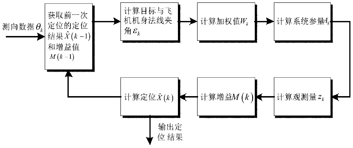
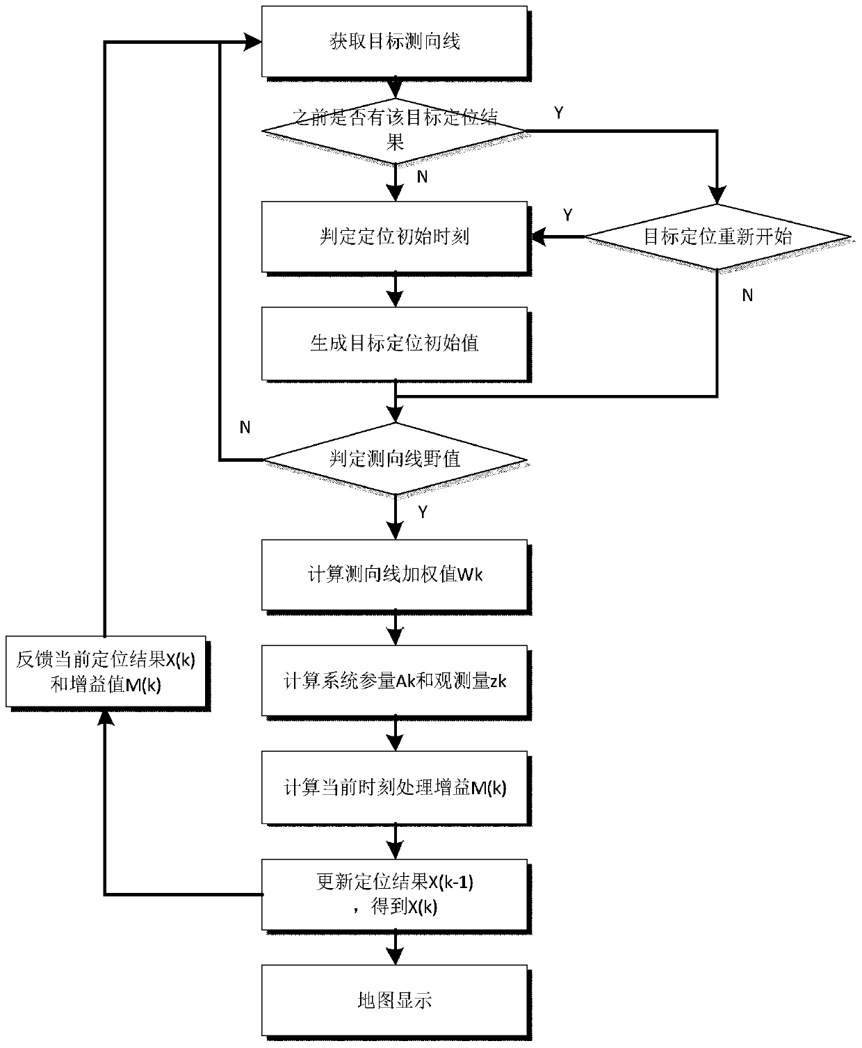
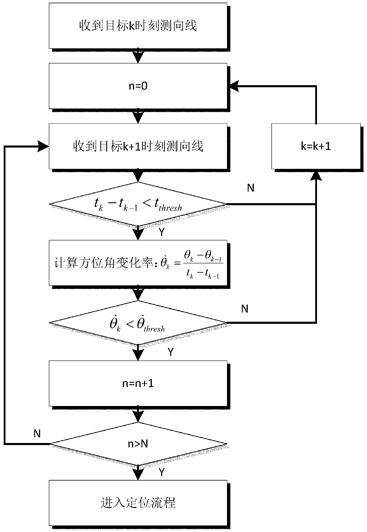
[0024] refer to figure 1 . According to the present invention, in the airborne passive direction finding system, MicrosoftVisualStudio is used as the development platform, and the hemisphere-based pseudo-linear weighted recursive least squares positioning algorithm is adopted to form the positioning processing software on the platform; the positioning processing software is based on the input DF data θ k , to obtain the positioning result at the previous moment and the gain value M(k-1), as the input quantity for positioning calculation at the current moment, and then according to the direction finding data θ of the aircraft at the current moment k and heading angle α k , based on the true north direction, calculate the angle ε between the target and the direction of the aircraft body k , and then according to the obtained angle ε between the target and the direction of the aircraft body k value, resulting in azimuth weighted value W k , and according to the latitude an...


PUM


Abstract

The present invention discloses an airborne direction finding and positioning method, and aims to provide a direction finding and positioning method for an airborne platform with small positioning error, high computational efficiency, fast convergence speed, strong anti-interference ability and strong adaptability. The method is realized by the following technical solution: in the passive airbornedirection finding system of the airborne platform, a positioning processing software based on a hemispherical pseudo-linear weighted recursive least squares localization algorithm is adopted to obtain a positioning result and a gain value of a previous moment, the result and value is used as input quantity of positioning calculation at a current time, an angle between a target and a direction ofan aircraft body is calculated, based on the north direction, to generate an azimuth weighting value, then according to latitude and longitude and a direction finding value of the aircraft platform, airborne direction finding system parameters, aircraft platform latitude and longitude, a direction finding value, an observation and measurement value are calculated; a positioning processing gain atthe current time is calculated; and the positioning result of the current moment is obtained and the positioning recursion is completed. The method solves the problem of optimal positioning solution of a large amount of direction finding data on the airborne platform.

Description

technical field [0001] The invention is an airborne direction-finding and positioning method that a passive direction-finding system of an airborne platform performs multiple times of direction-finding on the ground (sea surface) static or slow-moving target radiated wireless signals, and realizes fast positioning of the target. More specifically, the present invention relates to hemisphere-based pseudolinear weighted recursive least squares localization methods. Background technique [0002] The airborne platform is equipped with various passive systems, among which the passive direction-finding system realizes the detection and direction-finding of the wireless signal radiated by the target, and uses the high-speed maneuvering characteristics of the platform to move rapidly through the platform and detect the target radiation source at different positions. For direction finding data, the target position is obtained by the intersection of multiple direction finding lines. ...

Claims


Application Information

Patent Timeline
IPC IPC(8): G01S5/06
CPCG01S5/06
Inventor 曾斌杨春郑鲁腾
Owner 10TH RES INST OF CETC
Learn More