
Method and system for UAV visual landing based on 5G network

A drone and vision technology, applied in the field of drone visual navigation, can solve problems such as control errors, inaccurate landing positions, inaccurate positioning, etc., and achieve the effect of reducing transmission delay

Active Publication Date: 2021-07-27
JINAN UNIVERSITY
View PDF5 Cites 1 Cited by
  • Summary
  • Abstract
  • Description
  • Claims
  • Application Information

AI Technical Summary

Problems solved by technology

[0003] In order to overcome the shortcomings and deficiencies of the existing technology, the present invention provides a 5G network-based UAV visual landing method and system to solve the problem of control errors during manual landing and traditional UAVs using GPS systems for navigation and positioning. The inaccuracy leads to inaccurate landing positions. The invention cooperates with the visual algorithm and the ultrasonic sensor to complete the precise landing of the UAV. Based on the signal transmission of the 5G network, it realizes the ultra-high-definition real-time video transmission of the UAV.

Method used


Image

  • Method and system for UAV visual landing based on 5G network
  • Method and system for UAV visual landing based on 5G network
  • Method and system for UAV visual landing based on 5G network

Examples


Embodiment

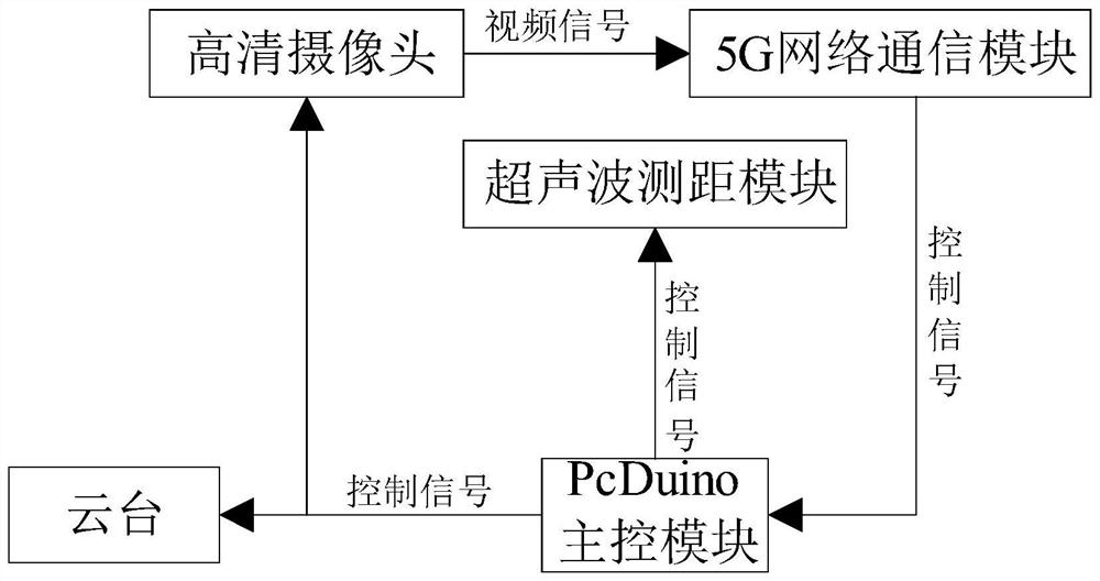
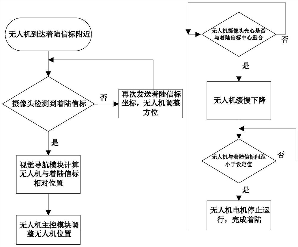
[0078] like figure 1 , figure 2 As shown, this embodiment provides a 5G network-based UAV visual landing system, including: UAV-side system and ground-side system,

[0079] The UAV-side system includes: a lithium battery, a pcduino main control module, a high-definition camera, a 5G network communication module at the UAV-side, and an ultrasonic ranging module. The lithium battery is used to supply power to the UAV; the pcduino The main control module is used to receive the control command of the ground terminal system, and control the work of the relevant modules on the drone terminal system; the high-definition camera is used to shoot high-definition images or videos; the 5G network communication module of the drone terminal is used to connect Access to the 5G network, and use the 5G network to realize ultra-high-definition real-time video transmission to the drone; the ultrasonic ranging module is used to measure the distance from the beacon when the drone lands.

[0080...


PUM


Abstract

The invention discloses a 5G network-based UAV visual landing method and system. The steps of the method are: the ground terminal system sends a landing control signal to the UAV; the UAV collects images through a high-definition camera, The terminal 5G network communication module transmits to the ground terminal system, the visual navigation module performs image recognition, and performs image grayscale processing and image edge detection on the collected images. When a landing beacon is detected, the visual navigation module calculates the UAV and landing signal The relative position of the target; the main control module of the drone adjusts the position of the drone until the optical center of the high-definition camera coincides with the center of the landing beacon; When the distance between the man-machine and the landing beacon is less than the set value, the drone will stop and complete the landing. The invention completes the precise landing of the UAV, performs signal transmission based on the 5G network, and realizes ultra-high-definition real-time video transmission of the UAV.

Description

technical field [0001] The invention relates to the technical field of UAV visual navigation, in particular to a 5G network-based UAV visual landing method and system. Background technique [0002] With the rapid development of the drone industry, the application of drones involves many industries, and there are many ways to control drones. The most common ones are manual remote control and ground station control. These two control methods are used in There are certain defects in controlling the UAV to land. When the UAV is landed manually, the UAV may be damaged due to improper operation; when the ground station controls the landing, the UAV cannot complete the precise landing due to positioning errors. On the other hand, most of the existing UAV visual landing methods use Wifi for image transmission, sometimes the image transmission is delayed due to signal reasons, and the transmission distance is also greatly limited. Contents of the invention [0003] In order to ove...

Claims


Application Information

Patent Timeline
Patent Type & Authority Patents(China)
IPC IPC(8): G06T7/13G06T5/00H04W4/40
CPCG06T7/13H04W4/40G06T5/70
Inventor 李伟华雷英佳杨皓然张敏佘佳俊梁祖懿张泽恒谭铭濠
Owner JINAN UNIVERSITY
Learn More