Eureka AIR delivers breakthrough ideas for toughest innovation challenges, trusted by R&D personnel around the world.

Goods delivery system based on GIS and GPS

A GPS positioning and cargo technology, applied in the field of logistics, can solve the problems of lack of professional talents, insufficient theoretical research, weak information infrastructure, etc., and achieve the effect of improving distribution efficiency.

Inactive Publication Date: 2019-10-11
国通北斗卫星信息化应用中心股份有限公司
View PDF3 Cites 0 Cited by
  • Summary
  • Abstract
  • Description
  • Claims
  • Application Information

AI Technical Summary

Problems solved by technology

[0004] However, the integration of geographic information system (GIS), satellite positioning system (GPS), wireless communication (WAP) and Internet technology (Web) in the field of logistics and supply chain management information technology has not yet fully matured in China.
[0005] The development of logistics under e-commerce in my country has not been long, and due to weak information infrastructure, insufficient theoretical research, and lack of professional talents, there are many problems in logistics management under e-commerce, especially for express delivery points. The delivery is chaotic, and the delivery cannot be arranged in an orderly manner when there are many goods

Method used


Image

  • Goods delivery system based on GIS and GPS

Examples


Embodiment Construction

[0017] The present invention will be described in detail below in conjunction with specific embodiments and accompanying drawings.

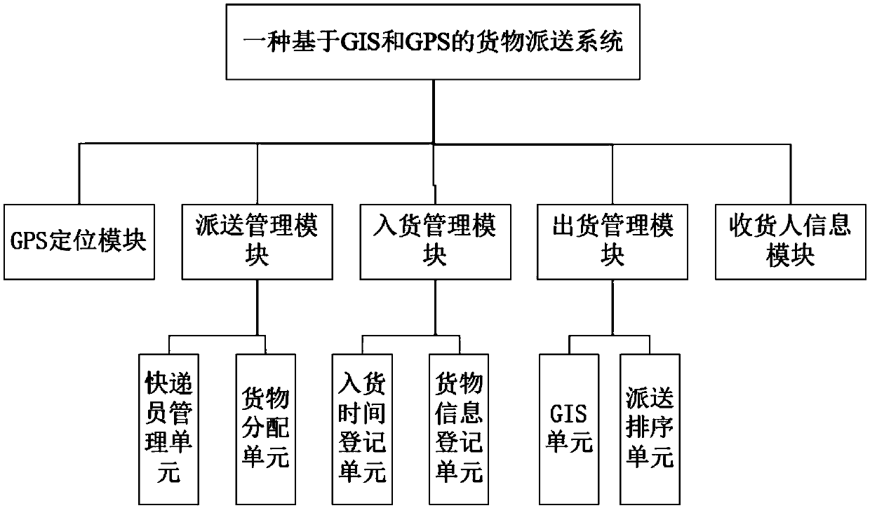
[0018] Such as figure 1 Shown is a GIS and GPS-based cargo delivery system, GPS positioning module, delivery management module, incoming goods management module, shipping management module, consignee information module, incoming goods management module records the information of the goods received, The delivery management module is responsible for sorting the delivery according to the information of the goods received; the delivery management module arranges the courier to deliver different goods according to the delivery order of the goods, and also plans the shortest delivery route of the goods based on GIS. The GPS positioning module is used for Get the real-time location of each courier.

[0019] Compared with the prior art, through the cooperation of various modules, the present invention not only registers the information of shipment and p...


PUM


Abstract

The invention particularly relates to a goods delivery system based on a GIS and a GPS. The system comprises a GPS positioning module, a delivery management module, a goods incoming management module,a goods outgoing management module, and a consignee information module. The goods incoming management module records the received goods information, and the goods outgoing management module is responsible for the delivery sorting according to the received goods information. The delivery management module arranges courier to deliver different goods according to the delivery order of the goods andplans the shortest delivery route of the goods based on the GIS, and the GPS positioning module is used for obtaining the real-time position of each courier. Compared with the prior art, through the cooperation of all the modules, the delivery and receiving information is registered, ordered delivery of goods is achieved, the courier position obtained by the GPS positioning module is beneficial for supervising the courier to conduct rapid delivery, the shortest delivery route is planned, and the delivery efficiency is greatly improved.

Description

technical field [0001] The invention relates to the field of logistics, in particular to a cargo delivery system based on GIS and GPS. Background technique [0002] With the development of modern commerce in our country, large and medium-sized cities will gradually form and build new large-scale logistics centers, and have large-scale logistics companies. The development of large-scale logistics centers and logistics enterprises has become an urgent requirement for logistics efficiency. Therefore, the application of geographic information system (GIS) is an indispensable tool for logistics centers, logistics enterprises, and distribution centers to improve efficiency. The development of the Internet and the advancement of communication technology, as well as the gradual maturity of cross-platform, componentized GIS (Geographic Information System) and GPS (Global Positioning System) technologies, enable GIS / GPS-based applications to construct competitive and transparent logis...

Claims


Application Information

Patent Timeline
Patent Type & Authority Applications(China)
IPC IPC(8): G06Q10/08
CPCG06Q10/0833G06F16/29
Inventor 余坤鸿林培川
Owner 国通北斗卫星信息化应用中心股份有限公司
Why Eureka
Eureka Blog
Learn More