Dynamic monitoring method for new plaques of spartina alterniflora
A technology of Spartina alterniflora and dynamic monitoring, which is applied in image data processing, instruments, character and pattern recognition, etc., and can solve the problems of increasing plaque recognition and monitoring errors and uncertainties
- Summary
- Abstract
- Description
- Claims
- Application Information
AI Technical Summary
Problems solved by technology
Method used
Image

Examples
Embodiment 1
[0070] see figure 1 ;
[0071] The dynamic monitoring method of the new patch of Spartina alterniflora comprises the following steps:
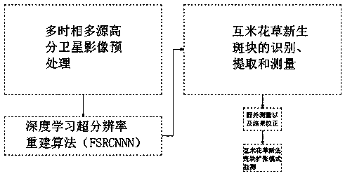
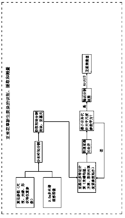
[0072] S1. Identification of potential colonization areas of new-born patches: Using medium-resolution remote sensing satellite images, according to the method of visual interpretation, and fully considering the temporal difference between Spartina alterniflora and other vegetation, identify Spartina alterniflora from sea to land The range boundary of Spartina alterniflora was combined with the tidal level data to obtain the intertidal zone range, so that the intertidal zone area where the range boundary of Spartina alterniflora was not identified was used as the potential colonization area of the new patch;
[0073] S2. Multi-source, multi-temporal and high-spatial-resolution satellite image collection: collect GF-1, GF-2, SPOT-6, or WorldView-2 images covering the above-mentioned potential colonization areas in the same peak growth season...
Embodiment 2
[0084] see figure 2 , based on Embodiment 1, the difference is that;
[0085] The image data preprocessing process mentioned in S3 is:
[0086] 1) Radiometric calibration: perform radiometric calibration on multispectral data and panchromatic data according to the Apply Gain and Offset tool provided by ENVI (Complete Remote Sensing Image Processing Platform);
[0087] 2) Atmospheric correction: use the FLAASH atmospheric correction module in the ENVI (Complete Remote Sensing Image Processing Platform) software to perform atmospheric correction on high-resolution multispectral images;
[0088] 3) Orthorectification: use DEM data to correct the image space distortion caused by the elevation fluctuation of the image, and generate a multi-center projection plane orthorectification image;
[0089] 4) Image fusion: use the Gram-Schmidt method to fuse the multi-source, multi-temporal, high-spatial-resolution satellite images to obtain the fused multi-temporal, multi-source, high-r...
Embodiment 3
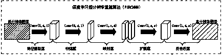
[0097] see image 3 , based on Embodiment 1 or 2, the difference is that;
[0098] The FSRCNN model mentioned in S4 is divided into five layers, which are feature extraction layer, shrinkage layer, mapping layer, expansion layer and reconstruction layer. The first four layers are convolution processing, which is used to extract low-dimensional data from high-dimensional data. ; and the last part of the reconstruction layer is deconvolution processing, which is used to map low-dimensional data into high-dimensional output, respectively use Conv(fi,ni,ci) to represent convolution processing, and DeConv(fi,ni,ci) to represent inverse Convolution processing, where the variables fi, ni, and ci represent the filter size, the number of filters, and the number of channels, respectively.
[0099] In this step, the high-score images of different resolutions (Table 1) are unified to a resolution of 0.5m through super-resolution reconstruction. The present invention uses the FSRCNN deep...
PUM
 Abstract
Description
Claims
Application Information
 - Generate Ideas
- Intellectual Property
- Life Sciences
- Materials
- Tech Scout
- Unparalleled Data Quality
- Higher Quality Content
- 60% Fewer Hallucinations
Browse by: Latest US Patents, China's latest patents, Technical Efficacy Thesaurus, Application Domain, Technology Topic, Popular Technical Reports.
© 2025 PatSnap. All rights reserved.Legal|Privacy policy|Modern Slavery Act Transparency Statement|Sitemap|About US| Contact US: help@patsnap.com