Integrated land and water self-adaptation mapping equipment for intertidal zone

A self-adaptive, intertidal zone technology, applied in the directions of surveying and navigation, measuring devices, section drawing, etc., to prevent overturning, improve adaptability, and reduce splashing

Active Publication Date: 2019-05-21
山东省国土测绘院
View PDF5 Cites 1 Cited by
  • Summary
  • Abstract
  • Description
  • Claims
  • Application Information

AI Technical Summary

Problems solved by technology

[0005] Aiming at the problems existing in the existing intertidal zone surveying and mapping devices, the present invention provides an integrated water and land adaptive surveying and mapping equipment suitable for the intertidal zone

Method used


Image

  • Integrated land and water self-adaptation mapping equipment for intertidal zone
  • Integrated land and water self-adaptation mapping equipment for intertidal zone
  • Integrated land and water self-adaptation mapping equipment for intertidal zone

Examples


Embodiment Construction

[0027] The specific embodiment of the present invention will be further described below in conjunction with accompanying drawing and specific embodiment:

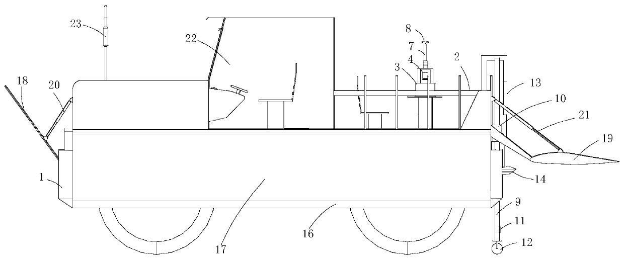
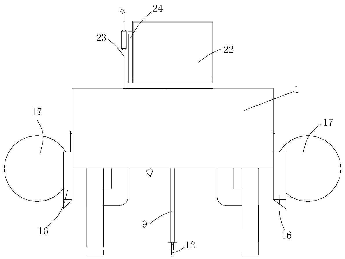
[0028] combine Figure 1 to Figure 7 An integrated water and land adaptive surveying and mapping device suitable for intertidal zones, comprising a high-ground-gap four-wheel drive vehicle, the high-ground-gap four-wheel drive vehicle includes a car body 1, and a surveying and mapping component is arranged on the upper and rear parts of the car body.

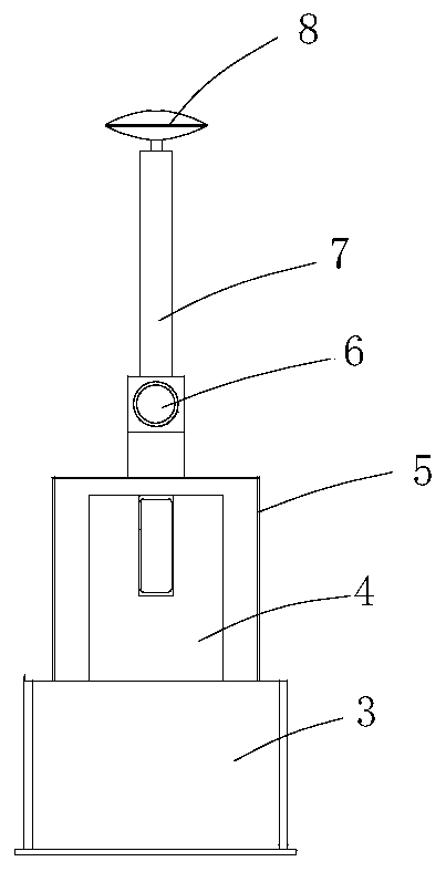
[0029] The surveying and mapping components include a supporting platform 2, a metal casing 3 is arranged on the upper surface of the supporting platform, a GNSS receiver and an inertial navigation system are packaged in the metal casing, a laser scanner 4 is connected to the metal casing, and a metal frame 5 is also arranged on the metal casing , the laser scanner is located in a metal frame, an industrial camera 6 is connected to the metal frame, a connecting rod 7 is conne...


PUM


Abstract

The invention provides integrated land and water self-adaptation mapping equipment for an intertidal zone. The integrated land and water self-adaptation mapping equipment comprises a high clearance four-wheel drive which comprises a drive body, and a mapping component is arranged on the upper rear portion of the drive body; extendable side skirts are arranged on the two sides of the drive body, and floats are fixedly connected to the side skirts. The mapping component comprises a supporting platform, a metal shell is arranged on the upper surface of the supporting platform, a GNSS receiver andan inertial navigation system are packaged in the metal shell, a laser scanner is connected to the metal shell, a metal frame is further arranged on the metal shell, the laser scanner is located in the metal frame, an industrial camera is connected to the metal frame, a connecting rod is connected to the industrial camera, and a GNSS antenna is arranged at the upper end of the connecting rod. A drag depth measuring device and a single beam depth measuring device are connected to the rear portion of the supporting platform. Through the integrated land and water self-adaptation mapping equipment for the intertidal zone, the multiple aspects of the carrier are optimized, and sufficient supports are provided when the blank region of the intertidal zone is measured.

Description

technical field [0001] The invention relates to the field of intertidal zone surveying and mapping, in particular to an integrated water and land self-adaptive surveying and mapping device suitable for the intertidal zone. Background technique [0002] The intertidal zone is the zone between the high and low tides where the estuary of the river or the coast is affected by the tides. The marine resources are extremely rich and the development potential is huge. First of all, the intertidal zone is an important zone of sea-land interaction, which contains rich environmental information and changes frequently. It is a reference for the study of modern coastal dynamic changes and environmental changes. Utilization activities are frequent and have important economic value. [0003] With the rapid development of the marine economy, human development activities in the intertidal zone are frequent and disorderly, and the situation of resource development and protection is becoming ...

Claims


Application Information

Patent Timeline
Patent Type & Authority Applications(China)
IPC IPC(8): B60F3/00G01C7/04
Inventor 魏国忠祝明然刘强赵中飞王红兵
Owner 山东省国土测绘院
Why Eureka
Try Eureka