Remote sensing estimation method for sea ice surface roughness

A technology of ice surface and roughness, applied in the application field of remote sensing geosciences, to achieve the effect of convenient data acquisition, clear operation steps and simple principle

Inactive Publication Date: 2019-03-26
NANJING UNIV
View PDF4 Cites 2 Cited by
  • Summary
  • Abstract
  • Description
  • Claims
  • Application Information

AI Technical Summary

Problems solved by technology

[0005] The technical problem to be solved by the present invention is to provide a method for inverting sea ice surface roughness based on AMSR-E brightness temperature and sea ice density data in view of the difficulty of measuring the surface roughness of sea ice on the spot, which can quickly and efficiently obtain from AMSR-E Obtaining polar sea ice surface roughness from E data products

Method used


Image

  • Remote sensing estimation method for sea ice surface roughness
  • Remote sensing estimation method for sea ice surface roughness
  • Remote sensing estimation method for sea ice surface roughness

Examples


Embodiment Construction

[0032] This example data is AMSR-E L3 level 25km resolution brightness temperature and sea ice density products, downloaded from NSIDC website (http: / / nsidc.org / ), the time is April 20, 2010, taking the Arctic region as an example .

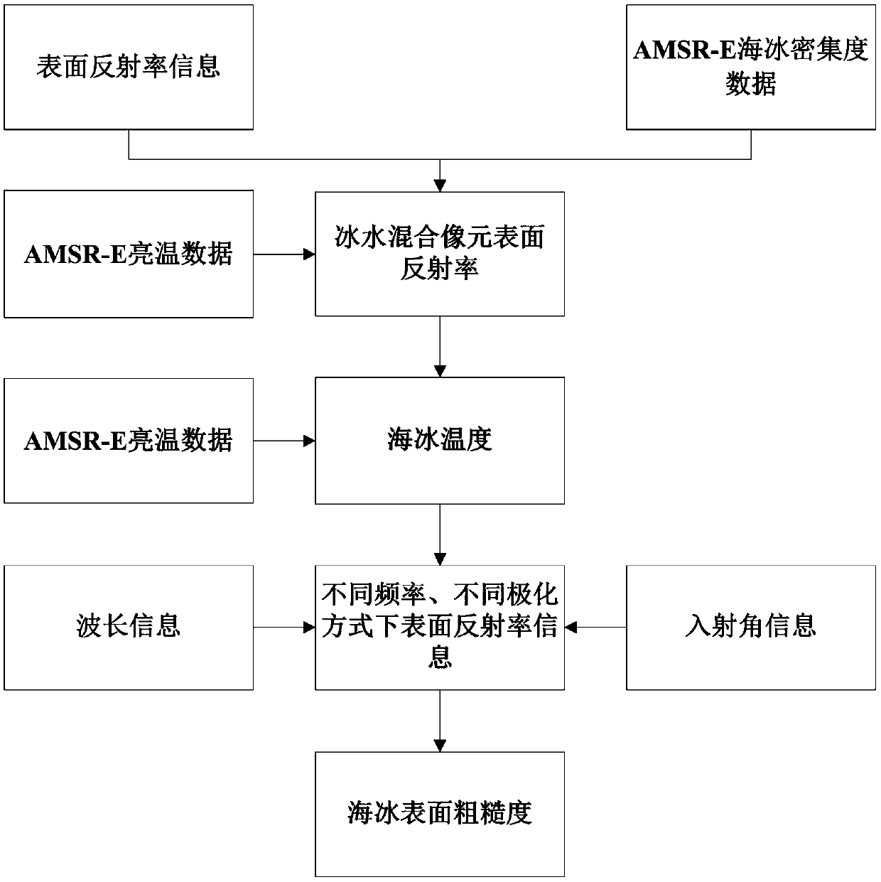
[0033] Such as figure 1 As the flow chart of this example, the specific implementation steps of the sea ice surface roughness remote sensing estimation method include the following:

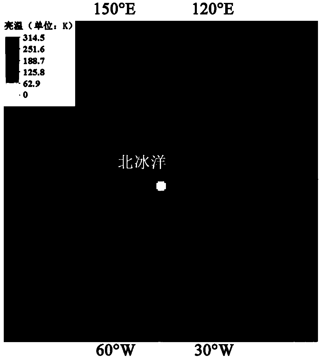
[0034] The first step is to prepare the data, extract and filter the data, and download the AMSR-E L3 level 25km resolution data product. Extract the density of sea ice and the brightness temperature of each pixel in the vertical polarization mode and horizontal polarization mode at 6.925GHz frequency, and eliminate invalid data according to the indicative parameters. The density of sea ice and the brightness temperature under vertical polarization at 6.925 GHz frequency are shown in Fig. 2(a) and Fig. 2(b), respectively.

[0035] The downloaded AMSR-E L3 level 2...


PUM


Abstract

The invention relates to a remote sensing estimation method for sea ice surface roughness, which is used for analyzing the spatial and temporal distribution and regional characteristics of polar region sea ice surface roughness based on passive microwave satellite remote sensing data. The method comprises the steps of: extracting sea ice density information and brightness temperatures of differentfrequencies and different polarization modes from AMSR-E data; obtaining the surface reflectivity of ice-water mixed pixels through the sea ice density information and known sea ice surface and sea water surface reflectivity information; obtaining sea ice temperature according to the surface reflectivity information and the brightness temperature of the mixed pixels; obtaining surface reflectivity information of different frequencies and different polarization modes through the sea ice temperature and the brightness temperatures of different frequencies and different polarization modes; and finally, obtaining the sea ice surface roughness based on a semi-empirical model of an incoherent method. According to the invention, the polar region sea ice surface roughness can be obtained from AMSR-E data products with high efficiency.

Description

technical field [0001] The invention relates to a remote sensing estimation method for sea ice surface roughness, and belongs to the technical field of remote sensing geoscience applications. Background technique [0002] Sea ice covers 5%-8% of the world's oceans and is an important part of the global climate system. Changes in sea ice are critical to the Earth's surface energy budget, atmospheric circulation, precipitation and water vapor fluxes, clouds, Earth's freshwater, and global temperature. The surface roughness of sea ice has a great influence on the microwave radiation of the sea ice / snow surface, and the research on the surface roughness of sea ice has attracted increasing attention from the scientific community. [0003] Spaceborne passive microwave sensors provide comprehensive and continuous observations of global sea ice. The Advanced Microwave Scanning Radiometer (AMSR) and Earth Observation System AMSR (EOS; AMSR-E) sensors have played an important role i...

Claims


Application Information

Patent Timeline
Patent Type & Authority Applications(China)
IPC IPC(8): G01B15/08
CPCG01B15/08
Inventor 柯长青满富康沈校熠蔡宇李萌萌
Owner NANJING UNIV
Why Eureka
Try Eureka