Construction of urban spatial characteristic index based on noctilucent remote sensing data and evaluation method of urban system
A technology of remote sensing data and spatial characteristics, applied in the field of space remote sensing, can solve the problems of outdated DMSP/OLS data, inability to reflect the detailed changes of time and space of regional urbanization development, and concentration in large areas, so as to achieve accurate and reliable data sources Effect
- Summary
- Abstract
- Description
- Claims
- Application Information
AI Technical Summary
Problems solved by technology
Method used
Image

Examples
Embodiment 1
[0036] Embodiment 1. Acquisition and extraction of urban lighting area data in the research area.
[0037] Taking Henan Province as the regional object. In view of the lack of spatial information in the statistical data of urban land area in Henan Province, it is difficult to meet the shortcomings of the research needs of urbanization spatial pattern and change process, and compare the advantages and disadvantages of each threshold extraction method in the extraction of urban spatial information in the existing research results, using statistical data The comparison method is improved on this basis to process the night light data of "Luojia No. 1" and accurately extract the urban light areas in the study area. After obtaining the “Luojia-1” luminous remote sensing image data in the evaluation area, splice and crop as needed (different areas may be completely covered by one scene to multiple scenes, so some areas need to be spliced; at the same time, the remote sensing image da...
Embodiment 2
[0040] Embodiment 2. Construct urban spatial characteristic index and urban system evaluation standard.
[0041] Based on the night light data of "Luojia No. 1", taking the extracted urban light area as the basic unit, a new light index that does not need to determine the weight but is simpler, has a certain physical meaning, and can reflect the comprehensive level of urban development is used as Index of urban spatial characteristics. At the same time, the regression model of this index and the composite index of urbanization level based on statistical data is established, and it is applied to the study of urban system for evaluation and analysis.
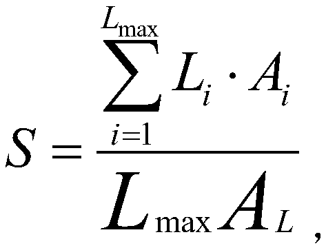
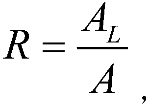
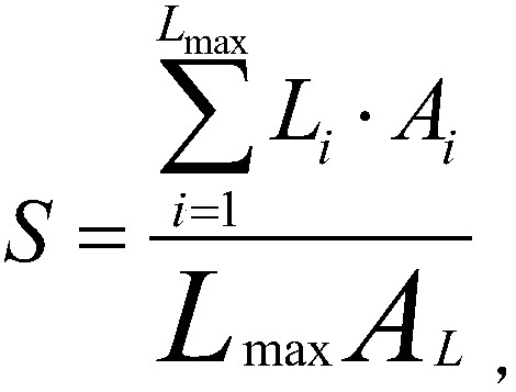
[0042] Specifically, the urban spatial characteristic index is named LuoJia-1 night light index, or LJ-1NLI for short. This index is the light index of the product of the relative light intensity of the regional light area and the area ratio of the light area. The advantage is that it does not require Determining the weight is a ...
Embodiment 3
[0050] Embodiment 3. Put forward suggestions and prospects for future urbanization development in combination with traditional urban geography theories.
[0051] The above-mentioned examples 1 and 2 take the urban system of Henan Province as the research object, take the night light data of "Luojia No. 1" as the main data, use GIS and RS as the main means of data processing and analysis, and combine various spatial data, Apply the theory of traditional urban geography to evaluate and look forward to the development of urbanization in the study area.
[0052] In this example, on the basis of accurately extracting the urban boundary based on the data of "Luojia No. 1" and constructing a new urban spatial characteristic index for the evaluation of the urban system in Henan Province, further, combined with the traditional urban geography theory, a proposal for future urbanization Suggestions and prospects for development.
[0053] Combining the road network, water system data and...
PUM
 Abstract
Description
Claims
Application Information
 - R&D
- Intellectual Property
- Life Sciences
- Materials
- Tech Scout
- Unparalleled Data Quality
- Higher Quality Content
- 60% Fewer Hallucinations
Browse by: Latest US Patents, China's latest patents, Technical Efficacy Thesaurus, Application Domain, Technology Topic, Popular Technical Reports.
© 2025 PatSnap. All rights reserved.Legal|Privacy policy|Modern Slavery Act Transparency Statement|Sitemap|About US| Contact US: help@patsnap.com